Method and system for computing road grade data

a technology of road grade and data, applied in the field of geographic databases, can solve the problems of not being used in a moving vehicle, providing inaccurate road grade measurements, and a significant task in collecting information for a geographic databas

Active Publication Date: 2005-02-15
HERE GLOBAL BV
View PDF18 Cites 55 Cited by
  • Summary
  • Abstract
  • Description
  • Claims
  • Application Information

AI Technical Summary

Problems solved by technology

Collecting information for a geographic database is a significant task.
One shortcoming of the mechanical road grade sensors is that they may provide inaccurate road grade measurements w

Method used


Image

  • Method and system for computing road grade data
  • Method and system for computing road grade data
  • Method and system for computing road grade data

Examples


Embodiment Construction

I. Geographic Database

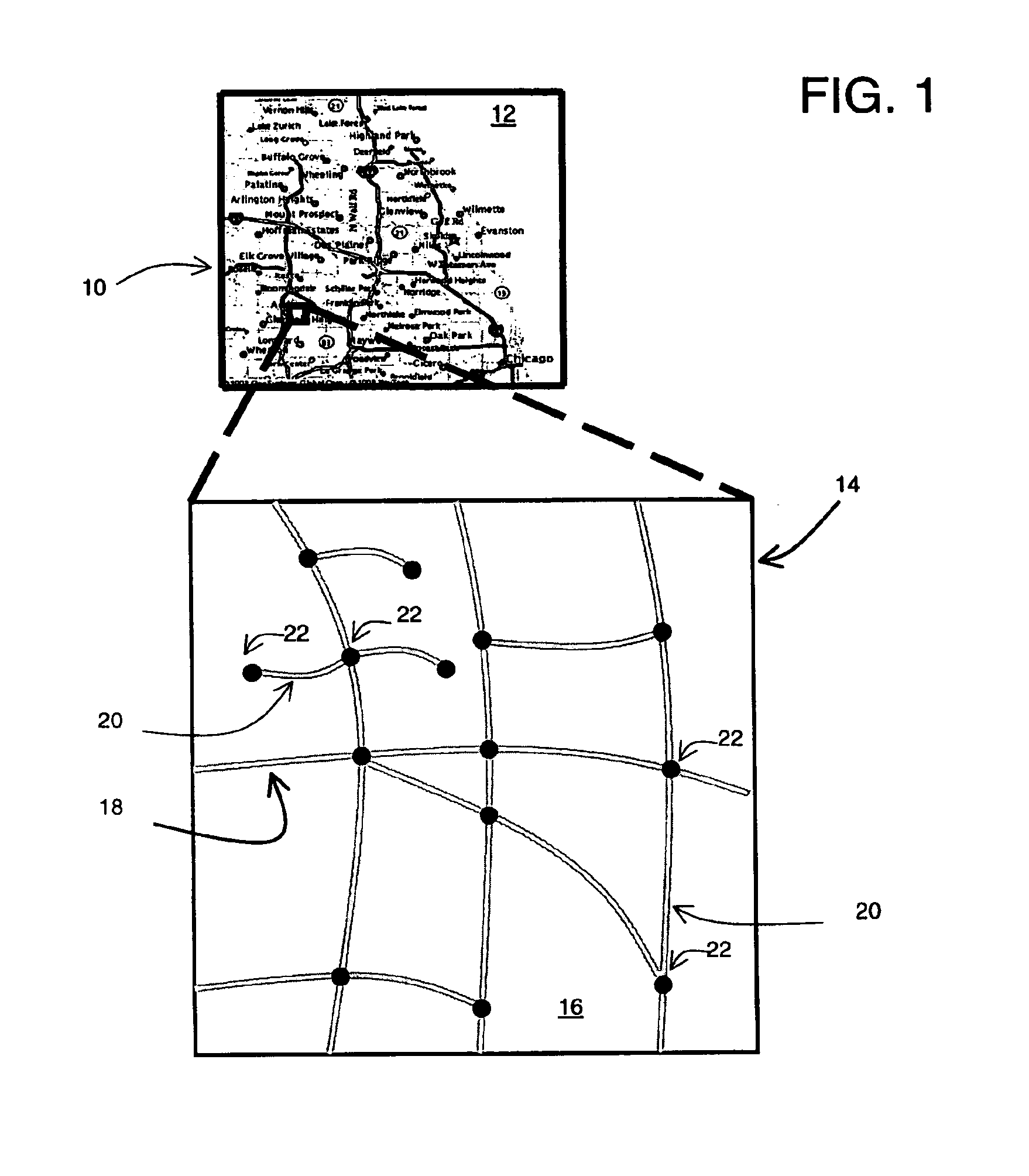
FIG. 1 shows a map 10 of a geographic region 12. The geographic region 12 may correspond to a metropolitan or rural area, a state, a country, or combinations thereof, or any other area of comparable size. Located in the geographic region 12 are physical geographic features, such as roads, points of interest (including businesses, municipal facilities, etc.), lakes, rivers, railroads, municipalities, etc.

FIG. 1 also includes an enlarged map 14 of a portion 16 of the geographic region 12. The enlarged map 14 illustrates part of the road network 18 in the geographic region 12. The road network 18 includes, among other things, roads and intersections located in the geographic region 12. As shown in the portion 16, each road in the geographic region 12 is composed of one or more road segments 20. A road segment 20 represents a portion of the road. Each road segment 20 is shown to have associated with it two nodes 22; one node represents the point at one end of the r...


PUM


Abstract

A method of obtaining data for a geographic database is disclosed. Data indicating a plurality of locations along roads including data indicating altitudes at the plurality of locations is provided. Road grade values for a plurality of subsections of the road are computed; each of the subsections is a portion of the road between two of the locations. A plurality of temporary change points are identified as joining two adjacent subsections having road grade values that differ by a value greater than a predetermined amount. Road grade values for each part of the road between adjacent temporary change points are computed. Consecutive parts of the road having road grade values that falls within a predetermined range are grouped into at least one constant road grade section. The geographic database stores data that define the constant road grade section.

Description

REFERENCE TO RELATED APPLICATIONThe present application is related to the co-pending application entitled “METHOD AND SYSTEM FOR OBTAINING ROAD GRADE DATA” filed on the same date herewith, the entire disclosure of which is incorporated by reference herein.BACKGROUND OF THE INVENTIONThe present invention relates generally to geographic databases, and more particularly, the present invention relates to a method and system for computing road grade data using collected altitude or elevation data.Geographic databases have various uses. Geographic databases are used in in-vehicle navigation systems, personal computers, networked computing environments, and various other kinds of platforms, as well as on the Internet. Geographic databases are used with various kinds of applications to provide various navigation-related and map-related functions including map display, route calculation, route guidance, truck fleet deployment, traffic control, traffic monitoring, electronic yellow pages, roa...

Claims


Application Information

Patent Timeline
IPC IPC(8): G01C21/28G01C21/26G06C21/00G06F17/30G06T17/05
CPCG06T17/05G06F17/30241G06F16/29Y10S707/99943
Inventor PHUYAL, BISHNUALWAR, NARAYANANDORUM, OLE HENRY
Owner HERE GLOBAL BV
Why Eureka
Try Eureka