Time determination in satellite positioning system receivers and methods therefor

a satellite positioning system and receiver technology, applied in the field of satellite positioning system receivers, can solve the problems of unreliable reception of 50 bps absolute time signals of navigation data messages, inability to decode tow data, and inability to reliably determine local time from gps satellite broadcast navigation data messages

Inactive Publication Date: 2005-09-13
GOOGLE TECHNOLOGY HOLDINGS LLC
View PDF46 Cites 165 Cited by
  • Summary
  • Abstract
  • Description
  • Claims
  • Application Information

AI Technical Summary

Problems solved by technology

GPS receivers cannot always reliably determine a local time from the GPS satellite broadcast navigation data message.
In these environments, reception of the 50 BPS absolute time signal of the navigation data message is unreliable.
Below a certain signal magnitude level it is possible to obtain a range measurement, but it is not possible to decode the TOW data.

Method used


Image

  • Time determination in satellite positioning system receivers and methods therefor
  • Time determination in satellite positioning system receivers and methods therefor
  • Time determination in satellite positioning system receivers and methods therefor

Examples


Embodiment Construction

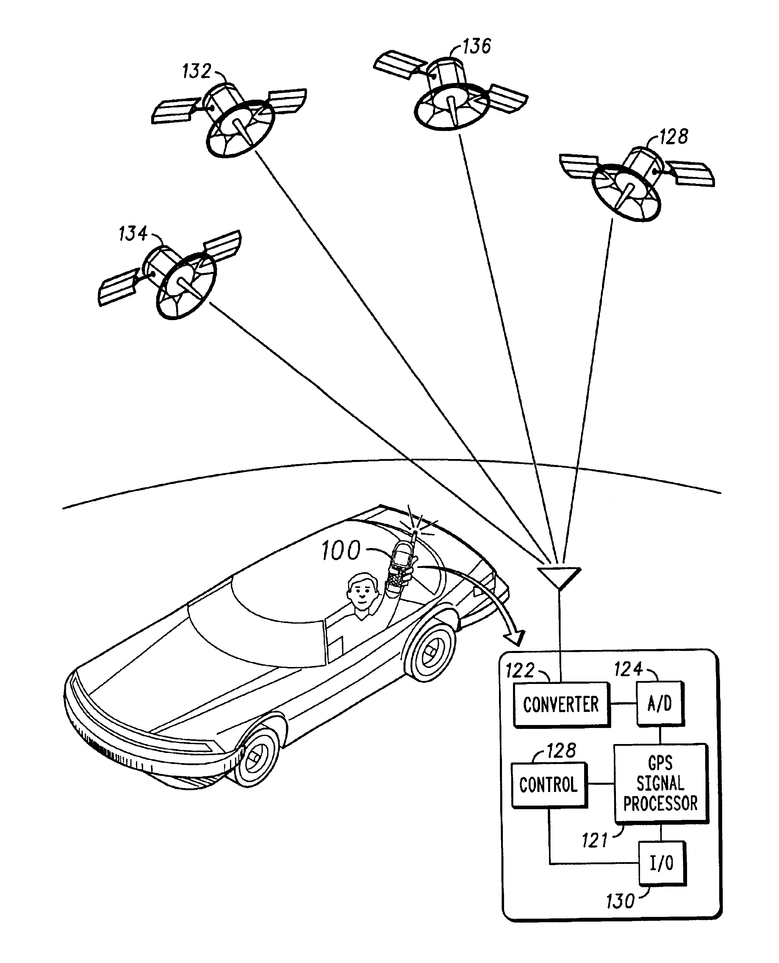
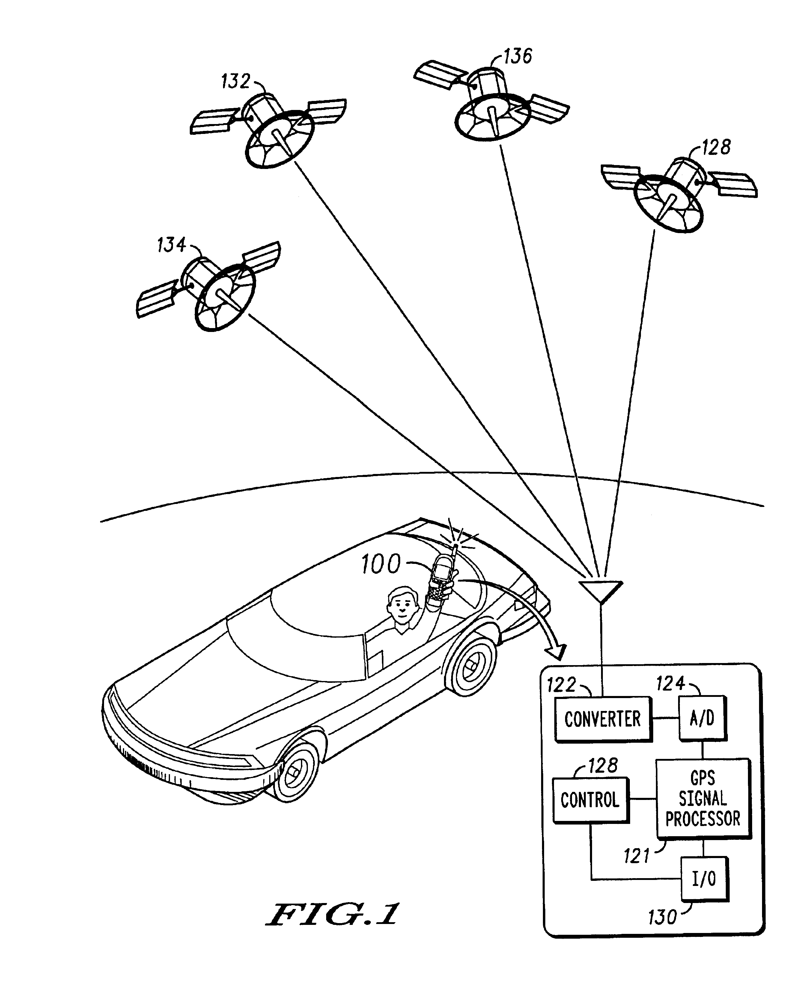
[0024]FIG. 1 illustrates a mobile satellite positioning system receiver, for example a GPS receiver integrated with a wireless cellular communications handset 100. FIG. 1 also illustrates a schematic block diagram of the exemplary GPS receiver portion 120 of the handset for receiving satellite signals from satellites 132, 134, 136 and 138 in a constellation of earth orbiting satellites.

[0025]In FIG. 1, the GPS receiver comprises generally a down converter 122 coupled to a GPS antenna, an analog to digital converter 124, a GPS signal processor 126 having a pseudorandom (PN) code phase and Doppler search space architecture, a controller 128 and an input / output (I / O) block 130 representative of a user interface, wireless communications circuitry interface, and other input and input / output ports. In other embodiments, the GPS receiver may be a stand-alone device, or it may be integrated with some other equipment.

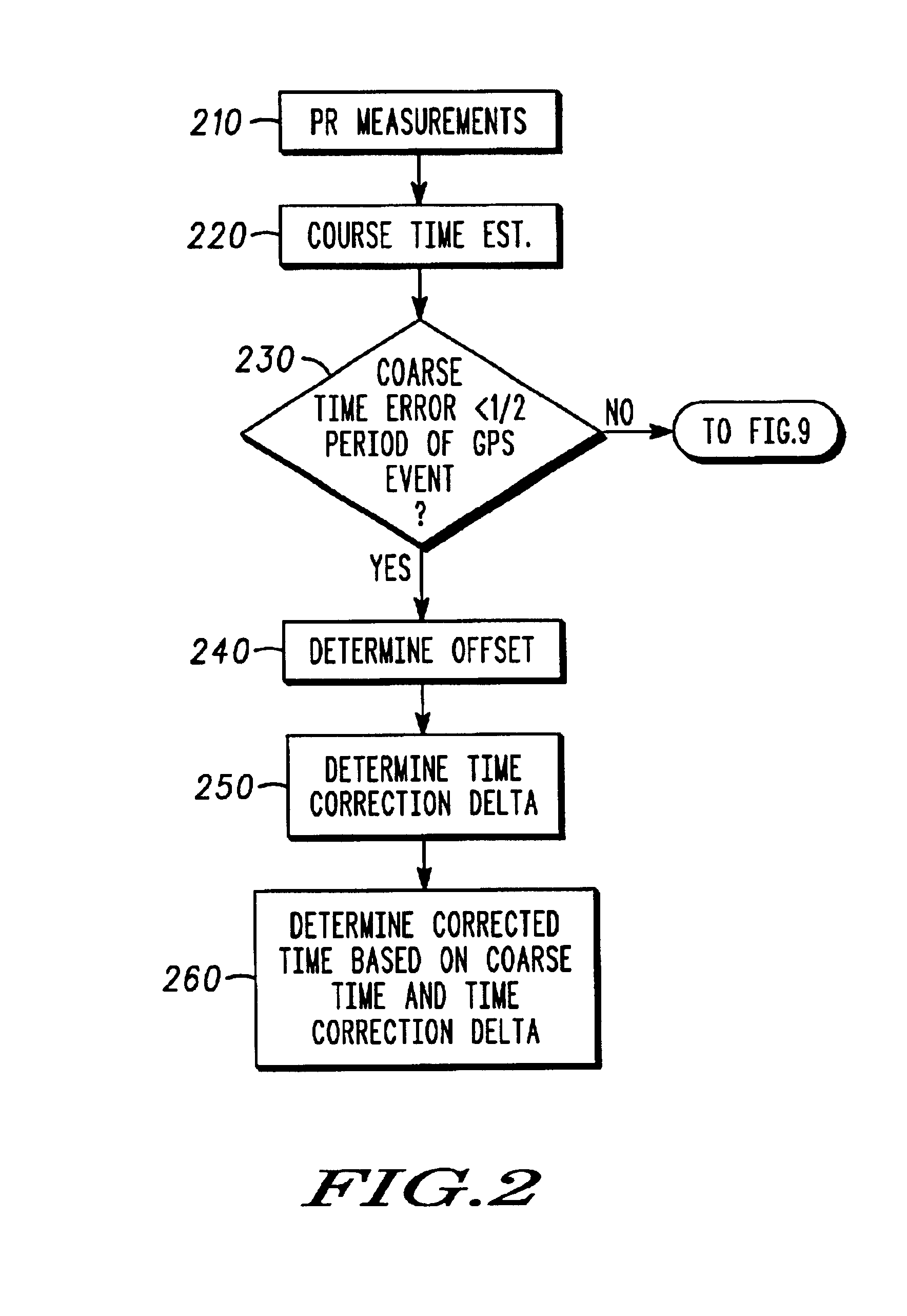
[0026]In the present invention, time is determined generally by synchronizi...


PUM


Abstract

Method in a Global Positioning System (GPS) receivers, including determining pseudorange (PNR) measurements for at least four satellites (210), determining a coarse time (220) corresponding to the pseudorange measurement, determining an offset time (240) between a periodic GPS event of one of the four satellites and the coarse time, determining a time correction delta (250) based upon the period of the Periodic GPS event, the offset time and the coarse time if an error of the coarse time is less than ½ the period of the periodic GPS event, and determining corrected time (260) based upon the coarse time and the time correction delta if the error of the coarse time is less than ½ the period of the periodic GPS event.

Description

FIELD OF THE INVENTIONS[0001]The present inventions relate generally to satellite positioning system receivers, and more particularly to time determination in satellite positioning system receivers, for example in Global Positioning System (GPS) enabled cellular radio communication handsets, and methods therefor.BACKGROUND OF THE INVENTIONS[0002]The Global Positioning System (GPS) is a satellite-based system developed by the United States Department of Defense to provide accurate positional information to a GPS receiver anywhere on earth, including its altitude. The GPS system comprises a constellation of 24 or more earth orbiting satellites in 12-hour orbits. The satellites are arranged in six orbital planes, each containing four satellites, spaced sixty degrees apart and inclined approximately fifty-five degrees from the equatorial plane. The constellation configuration ensures that between four and twelve satellites are visible at any time at any location on earth with a clear vi...

Claims


Application Information

Patent Timeline
Patent Type & Authority Patents(United States)
IPC IPC(8): G01S1/00G04G7/02G04G7/00G01S19/48
CPCG01S5/0221G01S19/235G01S19/256G04G7/02G04R20/06G01S2205/008G01S5/02216G01C21/26
Inventor KING, THOMAS MICHAELGEIER, GEORGE JEFFREYLANDERS, RODNEY PATRICKSLADE, MICHAEL JOSEPHDECLERCK, PAUL
Owner GOOGLE TECHNOLOGY HOLDINGS LLC
Why Eureka
Try Eureka