Determining A Dilution of Precision Metric Using Two or Three GPS Satellites

a technology of precision metric and satellite, applied in the field of hybrid positioning system, can solve the problems of not being useful in location determination, satellite positioning geometry bad, and set of satellites cannot be used for positioning, so as to improve the position estimate and improve the position estimate

Inactive Publication Date: 2011-04-07
SKYHOOK WIRELESS
View PDF100 Cites 111 Cited by
  • Summary
  • Abstract
  • Description
  • Claims
  • Application Information

AI Technical Summary

Problems solved by technology

For example, if all the satellites are exactly above the location of the receiver or very close to one another that set of satellites cannot be used for positioning.
Such cases provide bad geometry for satellite positioning.
Satellites in the proximity of other satellites and / or satellites aligned on the same plane (i.e. forming a coplanar problem) are normally not useful in location determination as they provide redundant information about receiver.
Similarly, when satellites are aligned in such a way that the plane which passes through them also passes through the receiver location (or close by locations) the range estimation from the satellites to the receiver are not independent and become redundant.
In both cases, the algorithm which solves the range estimation equations to find the receiver location will fail (or converge very slowly) as its input includes redundant data.
With fewer satellites, it is mathematically impossible to obtain a DOP0 value when traditional methods are used.
This fact poses a problem for hybrid positioning schemes with fewer than four visible satellites.

Method used


Image

  • Determining A Dilution of Precision Metric Using Two or Three GPS Satellites
  • Determining A Dilution of Precision Metric Using Two or Three GPS Satellites
  • Determining A Dilution of Precision Metric Using Two or Three GPS Satellites

Examples


case i

tellites

[0058]First, the embodiment using two satellites will be described. In this embodiment, it is assumed (1) the hybrid positioning system, for example as WLAN Positioning System (WLAN-PS), has an estimate of the receiver location which is referred to as initial estimated location (IEL), (2) there exist two visible satellites in the range of receiver's location device and (3) SPS is able to obtain range estimates and satellite information from these two satellites. The following method is used to determine whether or not the hybrid positioning system will use the satellite measurements for the final location determination. If, through the following method, it is determined that the satellites will provide accurate position measurements, then the satellites can be used in conjunction with the WLAN positioning system to determine the position of a device. However, if it is determined that the detected satellites are in such a configuration that they would provide inaccurate measu...

case ii

atellites

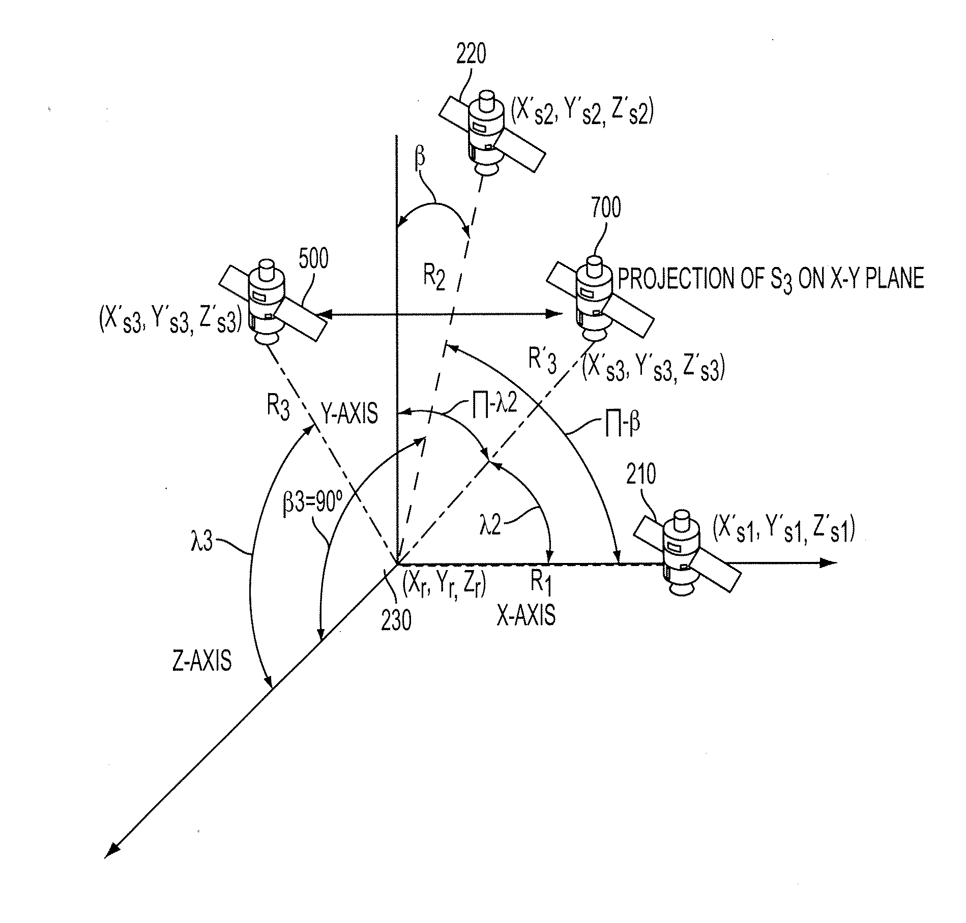
[0082]Another aspect of the present disclosure relates to evaluating the quality of satellite geometry where three satellites are in view. The case with three satellites is very similar to the two satellites embodiment. It is assumed that a positioning system has an IEL and is able to acquire signal from three satellites including pseudorange estimates and satellite information from these three satellites. To illustrate the concept of the present embodiment, FIG. 5 depicts a three satellite constellation; including a first satellite 210, a second satellite 220, and a third satellite 500 all located above the receiver location 230. DOP(S1,S2) 530 refers to the angle between first satellite and second satellite, DOP(S1,S3) 520 is the angle between the first satellite and third satellite, and DOP(S2,S3) 510 is the angle between the second satellite and third satellite.

[0083]The three satellite embodiment proposes three different approaches to obtain the relationship geometry b...


PUM


Abstract

The disclosed subject matter relates to a method for determining a Dilution of Precision Metric (DOP) with less than four satellites in a hybrid positioning system. In some embodiments, the method includes determining an initial position estimate of a device using a non-satellite positioning system, obtaining satellite measurements from less than four satellites, wherein the measurements include each satellite's position with respect to the initial position estimate, constructing a geometry matrix corresponding to the measurements from the less than four satellites using each satellite's position and the initial position estimate, multiplying the geometry matrix by its transpose to construct an H matrix, determining an inverse of the H matrix, and determining the DOP based on a sum of the diagonal elements of the inverse H matrix. In some embodiments, the non-satellite positioning system is a WLAN positioning system.

Description

CROSS-REFERENCE TO RELATED APPLICATIONS[0001]This application is related to the following references:[0002]U.S. patent application Ser. No. 12 / 479,721, filed Jun. 5, 2009 and entitled “Systems and methods for Using Environmental Information in a Hybrid Positioning System;”[0003]U.S. patent application Ser. No. 12 / 479,722, filed Jun. 5, 2009 and entitled “Systems and Methods for Maintaining Clock Bias Accuracy in a Hybrid Positioning System;”[0004]U.S. patent application Ser. No. 12 / 479,723, filed Jun. 5, 2009 and entitled “System and Method for Refining a WLAN-PS Estimated Location Using Satellite Measurements in a Hybrid Positioning System;”[0005]U.S. patent application Ser. No. 12 / 479,724, filed Jun. 5, 2009 and entitled “Systems and Methods for Determining Position Using a WLAN-PS Estimated Position as an Initial Position in a Hybrid Positioning System;”[0006]U.S. patent application Ser. No. 12 / 479,727, filed Jun. 5, 2009 and entitled “Methods and Systems for Improving the Accura...

Claims


Application Information

Patent Timeline
Patent Type & Authority Applications(United States)
IPC IPC(8): G01S19/48
CPCG01S19/48G01S19/28G01S19/426
Inventor ALIZADEH-SHABDIZ, FARSHIDHEIDARI, MOHAMMAD
Owner SKYHOOK WIRELESS
Why Eureka
Try Eureka