Method for depicting electronic navigation map and server

An electronic map and server technology, applied in the field of satellite navigation, can solve the problems of large processing burden, low response speed, poor map display smoothness, etc.

Active Publication Date: 2011-08-03
NAVINFO
View PDF0 Cites 19 Cited by
  • Summary
  • Abstract
  • Description
  • Claims
  • Application Information

AI Technical Summary

Problems solved by technology

[0007] Aiming at the problems in the related art that the data ranking of points of interest is carried out on the navigator end, the processing burden of the navigator is heavy, the response speed is reduced, and the smoothness of the map display is poor, the present invention proposes a method for drawing a navigation electronic map, It can reduce the processing burden of the navigator, improve the response speed of the navigator, and improve the

Method used


Image

  • Method for depicting electronic navigation map and server
  • Method for depicting electronic navigation map and server
  • Method for depicting electronic navigation map and server

Examples


Embodiment Construction

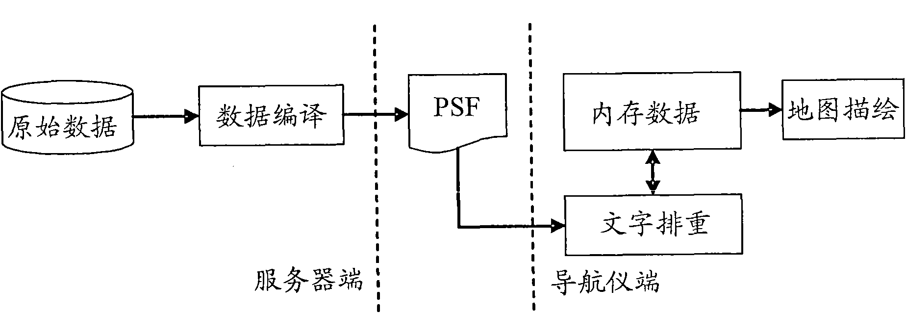
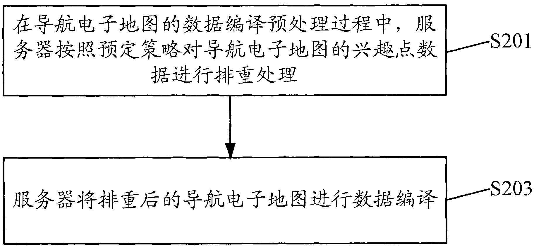
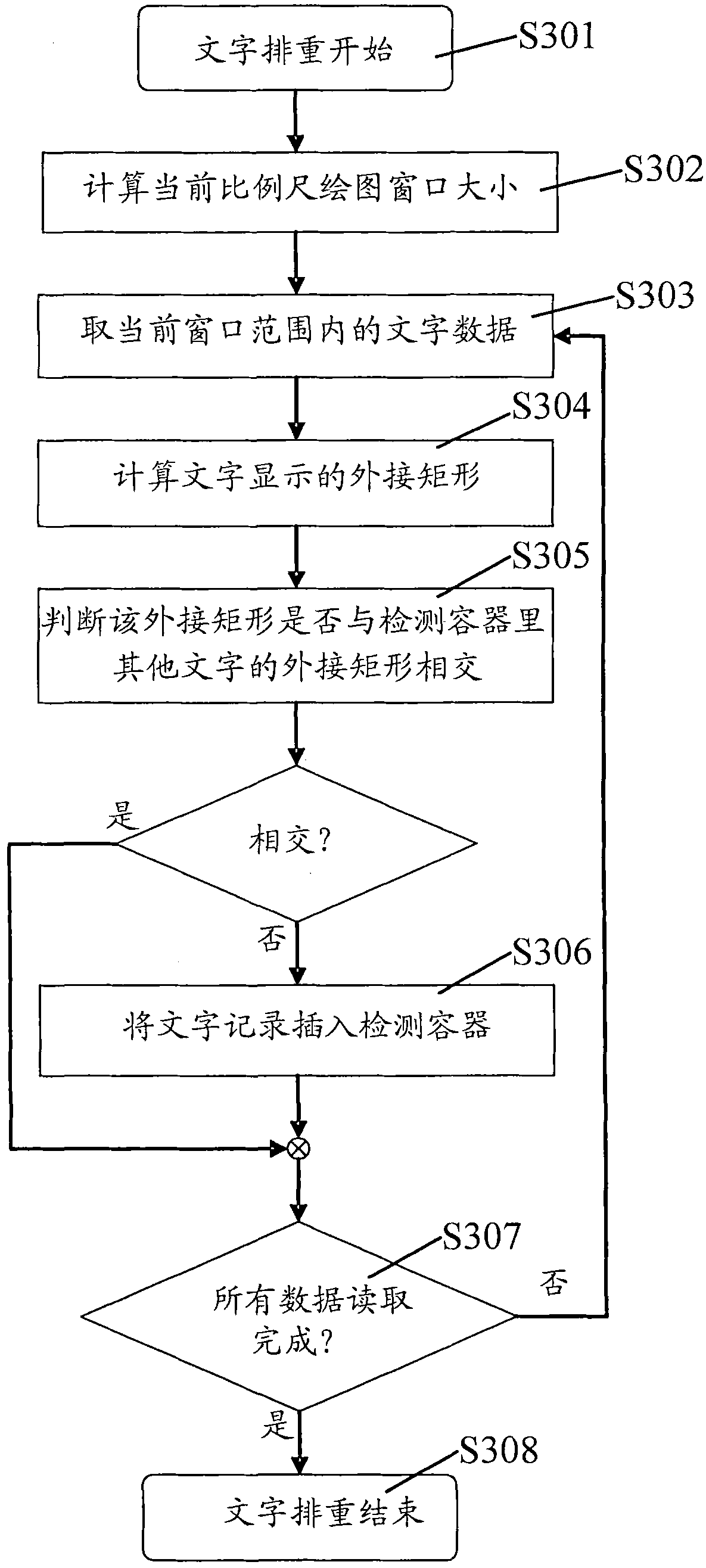
[0064] Considering that the current aviation software mainly refers to the traditional practice of geographic information system software in the electronic map rendering end, but geographic information system software often runs on high-performance personal computers (Personal Computer, referred to as PC) or servers, so , the impact of text deduplication on rendering performance is small; in comparison, most navigation software is run on embedded devices with low central processing unit (CPU) computing power and very scarce memory resources. Therefore, text deduplication is very important for navigation The drawing efficiency of the software has a great influence.

[0065] Although many navigation software manufacturers have made great improvements in the weight-removal algorithm, this improvement cannot fundamentally make up for the lack of processing capabilities of embedded devices such as navigators. At present, the continuous enrichment of POI and other text data is an un...


PUM


Abstract

The invention discloses a method for depicting an electronic navigation map and a server, wherein the method comprises: in the processing process of data compilation of the electronic navigation map, the server carries out repetition removal processing on the interest point data of the electronic navigation map according to a preset strategy; and the server carries out data compilation on the electronic navigation map subjected to repetition removal processing. By using the method disclosed by the invention, the operation of transferring the repetition removal processing on the interest pointdata to the high-performance server can be performed before data compilation, i.e., before the data is compiled into PSF (physical storage format) data, the repetition removal processing on the interest point data is completely finished, so that a navigator can directly carry out map depicting after the PSF data is loaded, therefore, a large amount of repetition removal processing carried out on the interest point data by the navigator can be avoided, the problem that the repetition removal processing on the interest point data occupies numerous processing resources in the navigator is solved, and the smoothness of map depicting and display on the navigator can be effectively improved.

Description

technical field [0001] The invention relates to the field of satellite navigation, in particular to a method for drawing a navigation electronic map and a server. Background technique [0002] With the rich content of navigation electronic maps, the richness of POI data has received more and more attention. In this way, it is necessary to continuously collect and update POI data, which will lead to more and more dense POI points contained in a unit area. If the POI data is not processed, POI text, road names and various annotations will be generated when the electronic map is drawn. Remember the phenomenon that words overlap each other. In order to eliminate this kind of overlapping, it is necessary to deduplicate the text. At present, the deduplication of the text is mainly performed by using the rendering end of the navigation software. [0003] Attached below figure 1 The text deduplication mechanism in the prior art is described. [0004] figure 1 It is a structural...

Claims


Application Information

Patent Timeline
IPC IPC(8): G01C21/32
Inventor 高剑王乐乐
Owner NAVINFO
Why Eureka
Try Eureka