Remote sensing image airplane detection method based on fusion of angle points and edge information

A remote sensing image and edge information technology, applied in the field of image recognition, can solve the problems of extracting the edge outline of aircraft targets, unsatisfactory detection results, weak anti-interference ability, etc., and achieve shortened processing time, low missed detection rate, and applicable wide range of effects

Inactive Publication Date: 2013-04-10
HOHAI UNIV
View PDF3 Cites 2 Cited by
  • Summary
  • Abstract
  • Description
  • Claims
  • Application Information

AI Technical Summary

Problems solved by technology

However, due to the influence of remote sensing image quality and aircraft shadows, usually the aircraft target will be broken into several areas after segmentation, and it is difficult to completely extract the edge contour of the aircraft target, so the usual method is to merge areas or connect edges
This method is not only very complicated to implement but also has weak anti-interference ability. At the same time, because there are many types of aircraft, it is difficult to use a unified template to detect all aircraft targets, so the detection results are often unsatisfactory.
A document ([Cai Hongping, Geng Zhenwei, Li Yi. A New Method for Aircraft Detection in Remote Sensing Images—Circumferential Frequency Filtering [J]. Signal Processing, Vol. 23, No. 4, 2007, 8:539-543]) proposed An aircraft detection method that adopts a top-down knowledge-driven strategy, but this method has a strong dependence on the gray value of the image, so for images with camouflaged aircraft targets or aircraft with weak distinction from the background, Many missed cases

Method used


Image

  • Remote sensing image airplane detection method based on fusion of angle points and edge information
  • Remote sensing image airplane detection method based on fusion of angle points and edge information
  • Remote sensing image airplane detection method based on fusion of angle points and edge information

Examples


Embodiment Construction

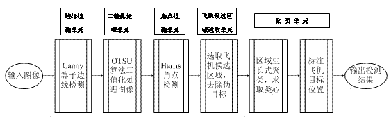
[0033] The technical scheme of the present invention is described in detail below in conjunction with accompanying drawing:

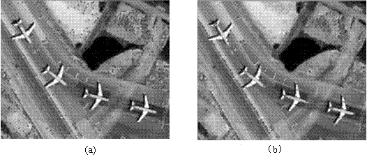
[0034] In real remote sensing images, the method of distinguishing aircraft targets from other interfering ground objects is mainly to use the gray scale, shape, size, shadow and other characteristics of aircraft targets in remote sensing images. The edge characteristics of the aircraft determine that there are abundant corner information at the aircraft target, which is different from the corner information in other areas. Simple consideration, the number of corner information at the aircraft target is limited, such as figure 2As shown, the picture (a) is the original image, and the picture (b) is the schematic diagram of the corner information of the aircraft. The aircraft detection method and detection system of the present invention are proposed according to the characteristics of the aircraft. Through experiments, it is found that if the corner ...


PUM


Abstract

The invention discloses a remote sensing image airplane detection method based on fusion of angle points and edge information. The method comprises the following steps of: executing edge detection on a remote sensing image; performing binarization on the detected remote sensing image; executing Harris angle point detection on the binarized remote sensing image; selecting regions in which the number of the angle points is in a predetermined range as candidate airplane regions; removing false target regions according to the number of bright pixels in each candidate airplane region; clustering the obtained image and marking a target airplane position, thus finally obtaining the number of obtained clusters and a central position of each cluster, wherein the number of the obtained clusters is the number of detected airplanes, and the central position of each cluster is the central position of a target airplane. The invention further discloses a remote sensing image airplane detection system comprising an edge connection unit, a binarization processing unit, an angle point detection unit, a candidate airplane region selection unit and a clustering unit which are orderly connected. Compared with the prior art, the method has the advantages of better detection effect and higher detection efficiency.

Description

technical field [0001] The invention relates to an image detection method, in particular to a method for using remote sensing images for aircraft detection, and belongs to the technical field of image recognition. Background technique [0002] With the rapid development of remote sensing technology, locating and identifying objects of interest in remote sensing images has become an important research direction. Using remote sensing images to detect targets has broad application prospects in both military and civilian fields. Especially in the military field, the use of remote sensing images to detect important military targets has been applied in national defense construction. As an important military target, the detection and identification of aircraft has always been a research hotspot. [0003] Object detection strategies are generally divided into two categories: one is called bottom-up data-driven strategy, and the other is called top-down knowledge-driven strategy. ...

Claims


Application Information

Patent Timeline
Patent Type & Authority Patents(China)
IPC IPC(8): G06K9/46G06T7/00
Inventor 李士进仇建斌王玮朱跃龙万定生冯钧
Owner HOHAI UNIV
Why Eureka
Try Eureka