Estimation method for unknown position based on internet initiative iteration detection

An Internet and active technology, applied in computing, instrumentation, electrical digital data processing, etc., can solve problems such as update difficulties, limited and missing location databases, etc.

Inactive Publication Date: 2013-05-01
WUHAN UNIV
View PDF2 Cites 7 Cited by
  • Summary
  • Abstract
  • Description
  • Claims
  • Application Information

AI Technical Summary

Problems solved by technology

[0004] The location database is limited in scale and difficult to update. The geographic location information query based on the location database (especially the fuzzy location query) may cause the location name to be difficult to identify or the coverage area to be missing, which is not enough to meet user needs.

Method used


Image

  • Estimation method for unknown position based on internet initiative iteration detection
  • Estimation method for unknown position based on internet initiative iteration detection
  • Estimation method for unknown position based on internet initiative iteration detection

Examples


Embodiment

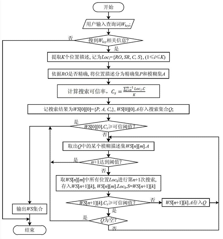
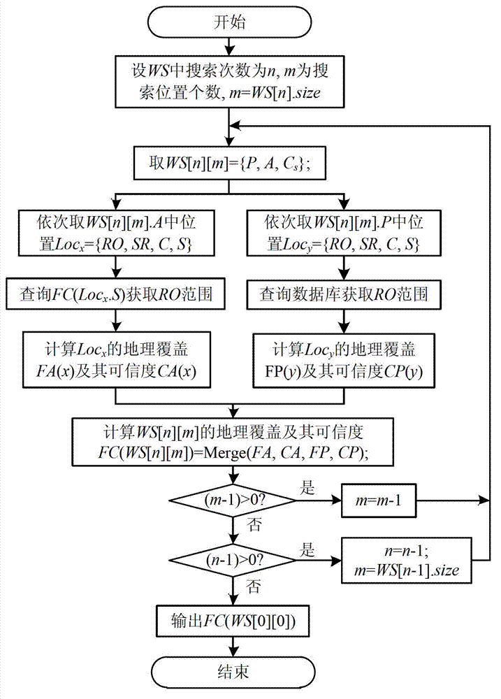
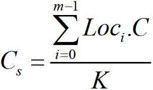
[0050] 1. Theoretical basis.

[0051] 1.1. Geographic Information Retrieval (GIR).

[0052] Geographic information retrieval is to return documents related to geographic information query according to the limitation of geographic query scope. The basic idea is to use web crawlers to search webpage collections from the Internet, identify place names in webpages through named entity recognition and classification, and grammatical analysis, so as to determine the geographical range of query words and documents, and finally calculate the correlation between documents and query words ( Including text association and spatial association) to return and sort the search results. At present, most geographic information retrieval mainly adopts keyword matching algorithm. Both search words and place names in network documents need to have a clear geographical coverage for association technology. This method is difficult to adapt to the situation of vague place names (such as the middle a...


PUM


Abstract

The invention relates to an estimation method for an unknown position based on internet initiative iteration detection. The estimation method comprises the following steps: 1, checking a user input position, and if the database query fails, utilizing a network engine to obtain a webpage set related to the position; 2, extracting a position description in the webpage and classifying; 3, calculating a credible rate Cs of a searching result, if the Cs meets a threshold Cmin, skipping to the step 5; 4, repeating the step 1 to step 3 for a fuzzy position in the searching result, till the credible rate meets the threshold or achieves a times limit; and 5, calculating a geographical range of the position description, fusing and obtaining an approximate geographical range of a target position. According to the estimation method provided by the invention, the rich and dynamically changing geographic knowledge resources in the internet are fully utilized and the approximate range of the unknown position is estimated. Specific to the text position description in various forms in the internet, a semantics based multi-scale position extracting method is adopted and a Point-Radius algorithm is utilized to estimate the approximate geographical range of the position.

Description

technical field [0001] The invention relates to an unknown location estimation method, in particular to an unknown location estimation method based on Internet active iterative detection. Background technique [0002] With the continuous development and improvement of GPS and other positioning technologies, the application fields of LBS (Location-Based Service) continue to expand, such as various electronic map service platforms (Baidu Map, Google Map, Bing Map, etc.), travel information Query system, daily life point of interest query system, traffic query system, social network, etc. There are two main methods for these location service platforms or systems to provide location information query: one is to use GPS positioning, map operations, etc. to obtain more accurate location coordinates for query; the other is to use natural language location description for query. There are many uncertainties in qualitative or semi-quantitative location descriptions, but they are mor...

Claims


Application Information

Patent Timeline
Patent Type & Authority Applications(China)
IPC IPC(8): G06F17/30
Inventor 呙维黄亮朱欣焰陈旭
Owner WUHAN UNIV
Why Eureka
Try Eureka