Navigation system, navigation method and device

A navigation method and a technology of a navigation device, applied in the field of navigation, can solve problems such as different degrees of information attention, the influence of scales, and different levels of content richness, and achieve the effects of ensuring driving safety, improving navigation efficiency, and enhancing navigation experience

Active Publication Date: 2017-11-28
SHANGHAI PATEO ELECTRONIC EQUIPMENT MANUFACTURING CO LTD
View PDF5 Cites 0 Cited by
  • Summary
  • Abstract
  • Description
  • Claims
  • Application Information

AI Technical Summary

Problems solved by technology

[0004] Since the navigation system can only display the partial electronic map and the guidance path obtained after the navigation calculus with a fixed scale (display scale), and the richness of content displayed under different scales is not the same, and in the navigation process, different places (For example, the distance from the intersection is different) the degree of attention to information is different, especially when the vehicle is driving to a road intersection such as a turn, a branch, and a high-speed entrance, it is necessary to provide an intuitive reminder of the follow-up direction, although usually the navigation system will Before arriving at the above-mentioned road intersections, voice navigation prompts are given, but the characteristics of the above-mentioned road intersections and surrounding information may not be displayed intuitively and clearly to the user with a suitable scale on the electronic map. For example, when the scale is small, it is difficult to reflect Details of road junctions
In the traditional navigation system, the scale does not change during the navigation process. If the user wants to change the scale, he needs to manually operate it. Undoubtedly, it will have adverse effects on driving safety
[0005] Related technologies can also refer to the Chinese patent application with publication number CN 101387521A, which discloses a method for adjusting the scale of the navigation map according to the driving speed of the vehicle. Although it can automatically adjust the scale of the navigation map, the size of the scale is affected by the driving speed. influence, and cannot intuitively show the navigation map that users want to see

Method used


Image

  • Navigation system, navigation method and device
  • Navigation system, navigation method and device
  • Navigation system, navigation method and device

Examples


Embodiment Construction

[0031] In order to make the above objects, features and advantages of the present invention more comprehensible, specific implementations of the present invention will be described in detail below in conjunction with the accompanying drawings. In the following description, specific details are set forth in order to provide a thorough understanding of the present invention. However, the present invention can be implemented in many other ways than those described here, and those skilled in the art can make similar extensions without departing from the connotation of the present invention. Accordingly, the present invention is not limited to the specific embodiments disclosed below.

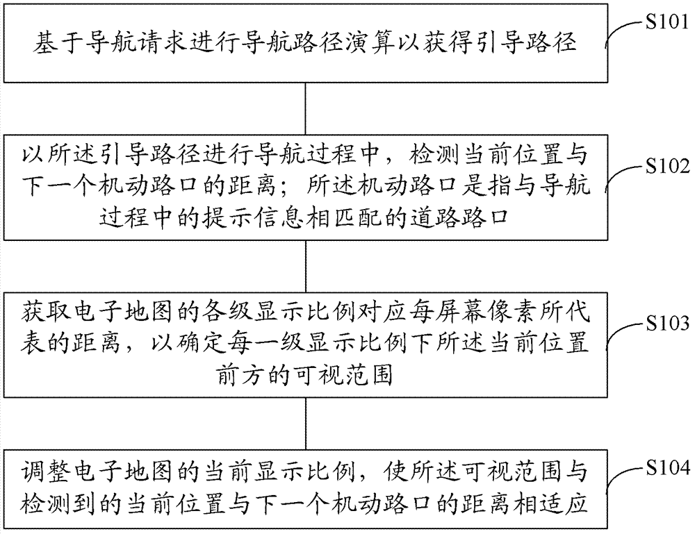
[0032] figure 1 It is a schematic flowchart of the navigation method provided by the embodiment of the present invention. like figure 1 As shown, the navigation method includes:

[0033] Step S101, performing navigation path calculation based on the navigation request to obtain a guidance path; ...


PUM


Abstract

A navigation system, navigation method and device, wherein the navigation method includes: performing navigation path calculation based on a navigation request to obtain a guidance path; during the navigation process using the guidance path, detecting the distance between the current position and the next maneuvering intersection; The motorized intersection refers to a road intersection that matches the prompt information in the navigation process; obtain the distance represented by each screen pixel corresponding to the display scale of each level of the electronic map, so as to determine the possible distance ahead of the current position under each level of display scale Visual range: adjust the current display scale of the electronic map, so that the visible range adapts to the detected distance between the current position and the next maneuvering intersection. The technical solution of the invention can automatically adjust the display scale of the electronic map during the guidance process, so as to ensure that the next motor crossing can always be properly displayed within the visible range ahead of the current position.

Description

technical field [0001] The invention relates to the technical field of navigation, in particular to a navigation system, a navigation method and a device. Background technique [0002] With the development of the automobile industry, people pay more and more attention to the user experience when using a car while owning a car. Existing in-vehicle devices can already provide users with many services, including services for multimedia needs such as music, video, and pictures, as well as driving navigation services such as real-time traffic information and destination maps. In particular, the use of vehicle navigation systems is becoming more and more popular. The voice prompts of the navigation system can guide the user to drive, especially when driving in an unfamiliar city, the navigation system can help the user to reach the destination conveniently and quickly. [0003] Navigation electronic map (which can be referred to as electronic map or navigation map for short), als...

Claims


Application Information

Patent Timeline
Patent Type & Authority Patents(China)
IPC IPC(8): G01C21/36G09B29/00
Inventor 鹿培信
Owner SHANGHAI PATEO ELECTRONIC EQUIPMENT MANUFACTURING CO LTD
Why Eureka
Try Eureka