Small watershed region-oriented landslide hazard risk division method based on mechanism analysis

A mechanism analysis, small watershed technology, applied in the direction of electrical digital data processing, special data processing applications, instruments, etc., can solve problems such as difficult practical application, spatial accuracy cannot meet the needs of disaster prevention and mitigation, and evaluation results cannot meet the accuracy requirements, etc. To achieve the effect of broad application prospects

Active Publication Date: 2013-12-18
GUANGZHOU INST OF GEOGRAPHY GUANGDONG ACAD OF SCI
View PDF4 Cites 33 Cited by
  • Summary
  • Abstract
  • Description
  • Claims
  • Application Information

AI Technical Summary

Problems solved by technology

In terms of spatial scale, there are currently two commonly used risk zoning scales. One is the regional scale with the administrative unit as the basic unit. The scale of landslide disasters is often only a few square meters to a few hectares. The spatial accuracy of the existing risk zoning It cannot meet the needs of disaster prevention and mitigation; the other is the zoning method based on the geographic grid as the basic unit. This traditional GIS-based unit grid calculation method evaluates the landslide risk at the small watershed scale, because it reflects the basis of the evaluation index. The mismatch between the data accuracy and the evaluation method, no matter how fine the cell grid is divided, the evaluation results are still difficult to meet the accuracy requirements
In short, the current risk analysis results are difficult to apply to practical applications for the grassroots frontline disaster prevention and mitigation managers in rural areas

Method used


Image

  • Small watershed region-oriented landslide hazard risk division method based on mechanism analysis
  • Small watershed region-oriented landslide hazard risk division method based on mechanism analysis
  • Small watershed region-oriented landslide hazard risk division method based on mechanism analysis

Examples


Embodiment

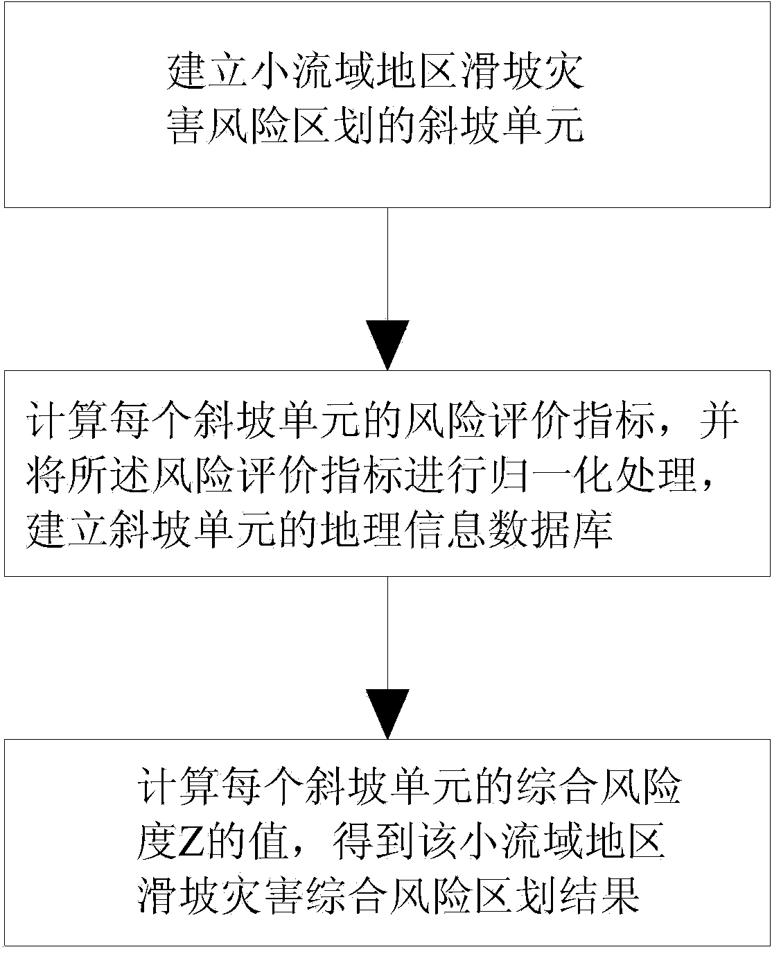
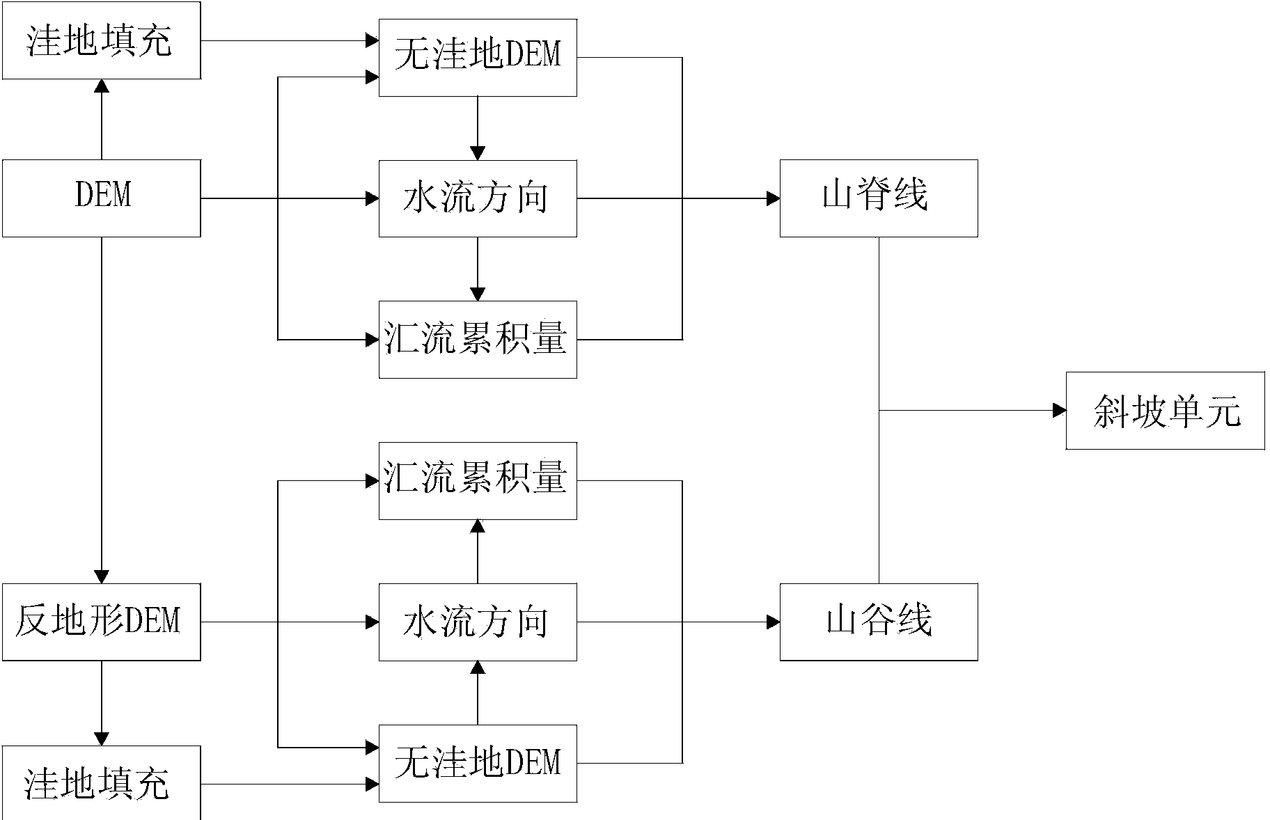
[0064] Please refer to figure 1 As shown, a landslide disaster risk zoning method in small watershed areas based on mechanism analysis includes three steps: Step 1, establish slope units for landslide disaster risk zoning in small watershed areas; Step 2, calculate risk evaluation indicators for each slope unit , and carry out normalization process to described risk evaluation index, set up the geographical information database of slope unit; Step 3, calculate the value of the comprehensive risk degree Z of each slope unit, obtain the integrated risk zoning result of landslide disaster in this small watershed area. The specific content is:

[0065] 1. According to the formation mechanism of landslide disasters in small watershed areas, establish slope units.

[0066] The present invention aims at the characteristics of landslide disasters in small watershed areas, based on the spatial distribution and geological environment characteristics of more than a thousand landslide di...


PUM


Abstract

The invention discloses a small watershed region-oriented landslide hazard risk division method based on mechanism analysis. The small watershed region-oriented landslide hazard risk division method based on the mechanism analysis comprises the following steps of: I. establishing slope units of small watershed region-oriented landslide hazard risk division; II. calculating a risk evaluation index of each slope unit, performing normalization processing on the risk evaluation indexes, and establishing a geographic information database based on the slope units; III. calculating a value of the integrated risk degree Z of each slope unit to obtain a small watershed region-oriented landslide hazard integrated risk division result. According to the small watershed region-oriented landslide hazard risk division method disclosed by the invention, on one hand, an index system and a space unit are started from a hazard formation mechanism, and therefore, the division result is more objective and scientific, and on the other hand, suitable spatial precision is provided for hazard prevention, so that the risk division result is more directive.

Description

technical field [0001] The invention relates to landslide disaster risk assessment technology, in particular to a method for landslide disaster risk zoning in small watershed areas based on slope units. Background technique [0002] A landslide is a process in which the slope rock and soil mass is deformed, destroyed and unstable under the action of triggering factors such as rainfall and human activities, and is affected by internal factors such as slope topography and geology. Among the geological disasters that have occurred, landslide disasters belong to the most serious category of sudden geological disasters. The number of such geological disasters in the world is large, the damage is great, and the loss is heavy, which has aroused people's extreme concern. big concern. Landslide risk zoning has gradually become a research hotspot in the field of disaster prevention and control in recent years. Disaster risk refers to the degree of disaster that may be reached in a n...

Claims


Application Information

Patent Timeline
Patent Type & Authority Applications(China)
IPC IPC(8): G06F19/00G06F17/30
Inventor 宫清华黄光庆袁少雄陈波张冬良熊海仙
Owner GUANGZHOU INST OF GEOGRAPHY GUANGDONG ACAD OF SCI
Why Eureka
Try Eureka