A platform for civil engineering geographic design based on soa architecture

A civil engineering, SOA technology, applied in computing, electrical digital data processing, special data processing applications, etc., can solve the problems of complex automatic calculation vertex importance algorithm, large memory data buffer space, large server request, etc., to achieve expansion Convenience, reduced model distortion, simple and easy functions

Inactive Publication Date: 2017-02-01
广西界围信息科技有限公司
View PDF2 Cites 0 Cited by
  • Summary
  • Abstract
  • Description
  • Claims
  • Application Information

AI Technical Summary

Problems solved by technology

The advantage is that it solves the problem of large server requests; the disadvantage is that a large memory data buffer space is required to save the used data
The third is the model simplification method. According to the importance of the points in the model, it is usually sorted according to the degree of influence on the volume, and a progressive data flow is established, and then dynamically loaded through the network. The disadvantage is that the algorithm for automatic calculation of vertex importance is complicated. It is easy to cause model distortion

Method used


Image

  • A platform for civil engineering geographic design based on soa architecture

Examples


Embodiment Construction

[0022] The present invention will be further described in detail below in conjunction with the accompanying drawings, so that those skilled in the art can implement it with reference to the description.

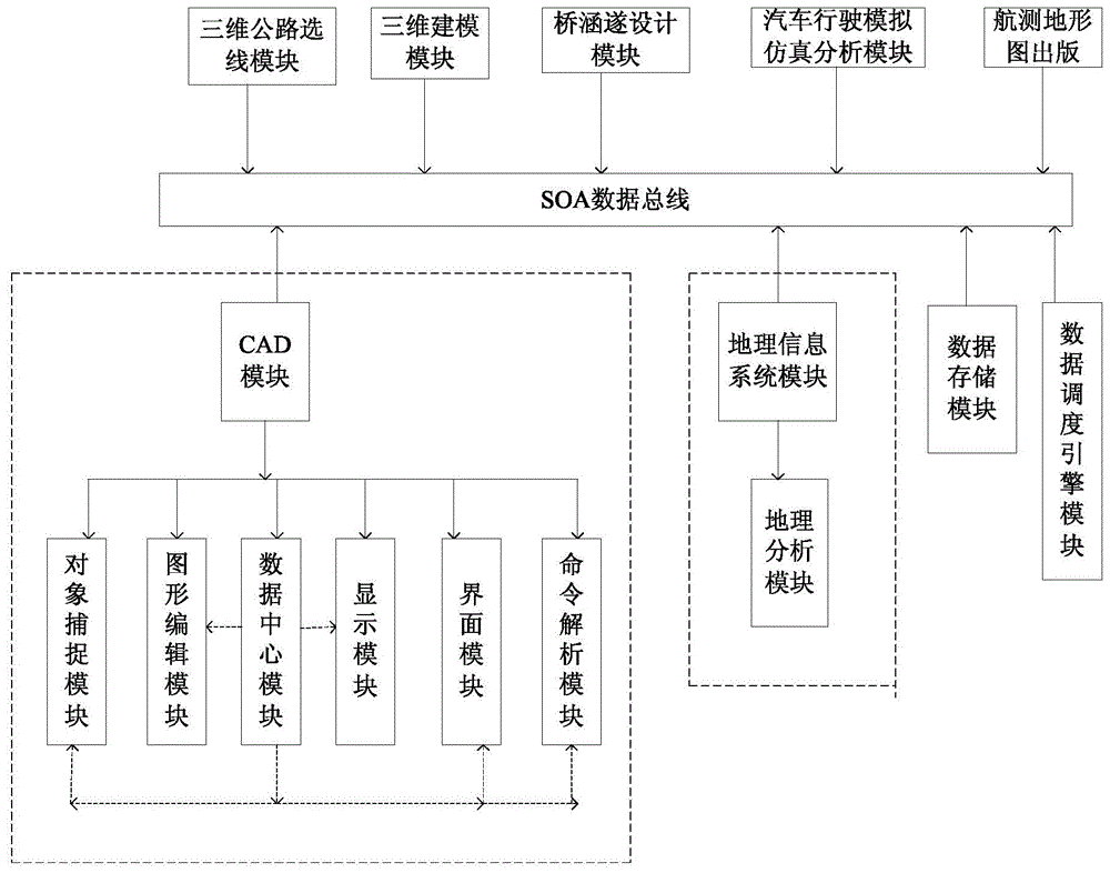
[0023] Such as figure 1 As shown, the present invention provides a kind of civil engineering geographic design platform based on SOA architecture, comprising:

[0024] SOA data bus, SOA is a service-oriented architecture, it is a component model, it can connect different functional units (called services) of the application through well-defined interfaces and contracts between these services, so it is connected to Different application modules on the SOA data bus can share each other, so the CAD module and the geographic information system module can be integrated together through the SOA data bus;

[0025]CAD module, which is connected to the SOA data bus, the CAD module is an embedded CAD core, which provides more than 20 kinds of basic primitive drawing, geometric attribu...


PUM


Abstract

The invention discloses a civil engineering geography design platform based on SOA architecture. The civil engineering geography design platform comprises an SOA data bus, a CAD module, a geographic information system module, a data storage module and a data scheduling engine module. The CAD module and the geographic information system module are connected to the SOA data bus. Geographic information system space model data and CAD space model data are stored in the data storage module and disintegrated into geometric primitive data namely point, line or surface data. Each point datum, each line datum or each surface datum after disintegration is associated with the space model data before disintegration through data structures. The data storage module is communicated with the SOA data bus through a point data interfaces, a line data interface and a surface data interface. The data scheduling engine module is connected to the SOA data bus. The platform has the advantages that geographic environment factors are combined with a design process, geometric primitive is used as intermediate data bridge, seamless integration of CAD data and GIS data is achieved, and fast scheduling and visualization of massive data is researched on the basis of the integration.

Description

technical field [0001] The invention belongs to the field of civil engineering design, in particular to a civil engineering geographic design platform based on SOA framework. Background technique [0002] The data used by the two disciplines of CAD (Computer Aided Cartography) and GIS (Geographic Information System) can be summarized as flat or three-dimensional spatial data from a mathematical perspective. However, the focus of the research of these two disciplines is different. The content of CAD research mainly lies in refined mapping, and the content of GIS research mainly lies in the management, analysis and application of spatial data. In some fields, especially in the field of civil engineering, it is often necessary to use the knowledge of these two disciplines together; in order to solve these interdisciplinary engineering problems, people invented a new discipline "geographical design", which has become the current GIS and The hottest research topic in the field o...

Claims


Application Information

Patent Timeline
Patent Type & Authority Patents(China)
IPC IPC(8): G06F17/50
Inventor 潘树青韦喆叶家发梅树红韦心意
Owner 广西界围信息科技有限公司
Why Eureka
Try Eureka