Intelligent drawing method and system of sedimentary facies map for oilfield exploration and development

A sedimentary facies map and intelligent technology, applied in the field of petroleum exploration, can solve problems such as difficult editing operations, poor shape of facies belt area, and inability to guarantee the width of river channels, etc., to achieve simple operation, optimized mapping effect, and convenient editing

Active Publication Date: 2017-05-31
BEIJING GOLDENSUN PETROLEUM TECH
View PDF4 Cites 0 Cited by
  • Summary
  • Abstract
  • Description
  • Claims
  • Application Information

AI Technical Summary

Problems solved by technology

However, there are still some disadvantages as follows: using indicator kriging interpolation will result in bad shape of the facies zone, this method cannot guarantee the width of the channel, and there will be isolated facies zones in areas without well point control; Phase sequence constraints in the junction area; this method is basically difficult to edit because it is a one-time mapping

Method used


Image

  • Intelligent drawing method and system of sedimentary facies map for oilfield exploration and development
  • Intelligent drawing method and system of sedimentary facies map for oilfield exploration and development
  • Intelligent drawing method and system of sedimentary facies map for oilfield exploration and development

Examples


specific Embodiment

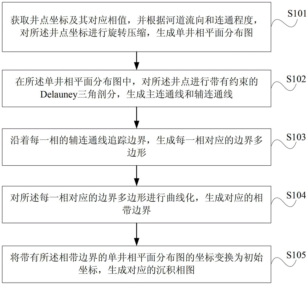
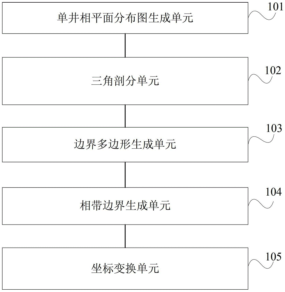
[0059] Step 1. Preprocessing to generate plane distribution map of single well facies

[0060] (1) Obtain the position coordinates of the well point and the corresponding phase value, and input the phase sequence label information; among them, the phase sequence label information is set as follows: the channel phase sequence label is the largest, the smallest outside the table, marked as phase 0, and the rest are in the middle Arranged in order.

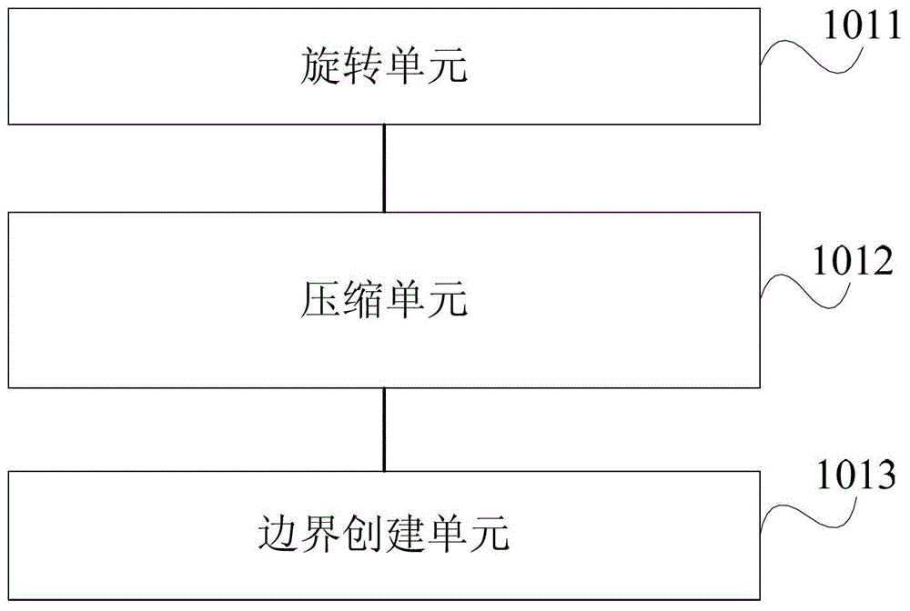
[0061] (2) Carry out coordinate transformation on the well points according to the requirements of the flow direction and degree of connectivity of the river course. The method is to first rotate the coordinates of the well point so that the flow direction of the river is the positive direction of the y-axis. Compression is then carried out along the flow direction of the river, and the compression ratio is determined by the degree of connectivity.

[0062] (3) If there is no outer boundary, a boundary is automatically created.

...


PUM


Abstract

The embodiment of the present invention discloses a method of intelligently drawing a sedimentary face map facing the oilfield exploration and development, and a system of intelligently drawing the sedimentary face map facing the oilfield exploration and development. The method comprises the steps of obtaining the coordinate of a well point and a face value corresponding to the coordinate, and rotating and compressing the coordinate of the well point according to the flow direction of a riverway and the communication degree to generate a single well face plane distribution map; in the single well face plane distribution map, carrying out a Delauney triangulation with constraint on the well point to generate a main communication line and an auxiliary communication line; tracking a boundary along the auxiliary communication line of each face to generate a boundary polygon corresponding to each face; curving the boundary polygon corresponding to each face to generate a corresponding phase spread boundary; transforming the coordinate of the single well face plane distribution map with the phase spread boundary into an initial coordinate, and generating the corresponding sedimentary face map.

Description

technical field [0001] The invention relates to the field of petroleum exploration, in particular to an intelligent drawing method and system for sedimentary facies diagrams oriented to oilfield exploration and development. Background technique [0002] In the process of oilfield geological modeling, modeling sedimentary facies is a very important step. In practice, modeling of sedimentary facies is carried out as follows: [0003] 1. Analyze the logging curves, determine the paleo-sedimentary environment of the entire block, and divide the strata; [0004] 2. Determination of sedimentary facies on the log curve after layering; [0005] 3. Combining the analysis data of all well logs, for each formation, draw a sedimentary facies map according to the sedimentary facies of all logging positions in the formation. [0006] In oilfield field work, the existing method of drawing sedimentary facies maps is often carried out by manual hand drawing, so the efficiency is low, edit...

Claims


Application Information

Patent Timeline
Patent Type & Authority Patents(China)
IPC IPC(8): G06T11/00
Inventor 袁钢辉齐建军于艳矫树春
Owner BEIJING GOLDENSUN PETROLEUM TECH
Why Eureka
Try Eureka