Method for fusing and integrating multi-source spatial data

A technology of data fusion and source space, applied in the field of computer information, can solve problems such as low access efficiency of shared data, incomplete information of element objects, etc., and achieve the effect of solving low access efficiency of shared data and improving access efficiency

Active Publication Date: 2015-02-18
XIAN FUTURE INT INFORMATION CO LTD +1
View PDF2 Cites 14 Cited by
  • Summary
  • Abstract
  • Description
  • Claims
  • Application Information

AI Technical Summary

Problems solved by technology

[0004] The purpose of the present invention is to provide a method for multi-source spatial data fusion and integration, which solves the problems of incomplete element object information and low access efficiency of shared data under the Web service mode when the existing multi-source spatial data format is processed

Method used


Image

  • Method for fusing and integrating multi-source spatial data
  • Method for fusing and integrating multi-source spatial data
  • Method for fusing and integrating multi-source spatial data

Examples


Embodiment Construction

[0024] The present invention will be described in detail below in conjunction with the accompanying drawings and specific embodiments.

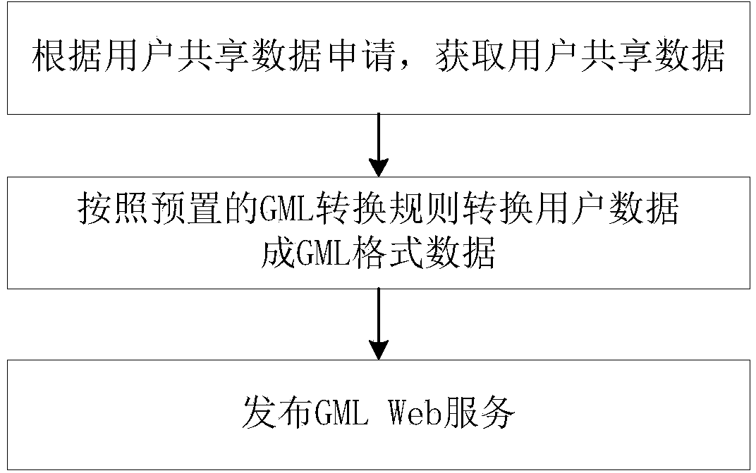
[0025] A method for fusion and integration of multi-source spatial data in the present invention, such as figure 1 As shown, the specific steps are as follows:

[0026] Step 1, the user sends a data sharing request to the administrator, wherein the data sharing request includes a data sharing application and a data sharing description;

[0027] Step 2. The administrator receives the data sharing request and approves whether the user is allowed to share the data. If the approval is passed, the user sorts and uploads the data to be shared to the server according to the complete element object, and performs step 3; if the approval is not If passed, the administrator will return the message that the approval fails to pass to the user;

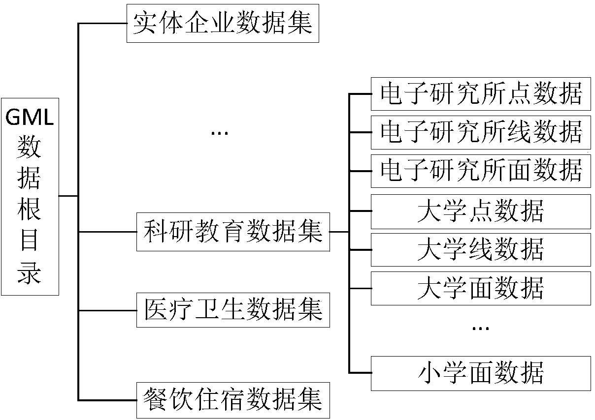
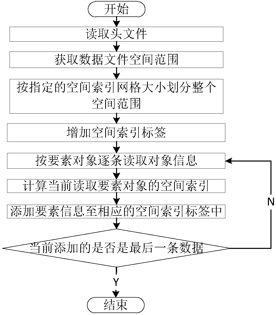
[0028] Step 3, the administrator invokes the data conversion function of the platform, and converts the data ...


PUM


Abstract

The invention relates to a method for fusing and integrating multi-source spatial data. The method specifically comprises the following steps that: a user sends a shared data request to an administrator; the administrator receives the shared data request and examines and approves whether the user is allowed to share data or not; if the examination and the approval are passed, the user organizes and uploads the data required to be shared to a server according to a complete element object and implements the step III; if the examination and the approval are not passed, the administrator returns the message which implies that the examination and the approval are not passed to the user; the administrator invokes a platform data conversion function, and an object-oriented approach is adopted in the platform data conversion to convert the data shared by the user to data adopting a GML (Geography Markup Language) format; the administrator distributes the data required by the user in the GML format according to the user demands. The method for fusing and integrating the multi-source spatial data has the benefits that the problems that element object information is incomplete when existing multi-source spatial data is subjected to format processing, and the access efficiency of the shared data in a Web service mode is low are solved.

Description

technical field [0001] The invention belongs to the technical field of computer information and relates to a method for fusion and integration of multi-source spatial data. Background technique [0002] With the rapid development of urban digitalization, the gradual construction of digital city sharing platforms and enterprise-level shared service platforms, spatial information services will promote the development of industry applications in the direction of vertical penetration and horizontal integration, and multi-source spatial data fusion based on heterogeneous GIS platforms And integration is bound to become a new demand for industry users. The diversification of data sources and the difference in format make how to deal with the format of spatial data the key to determine the fusion and integration of multi-source spatial data. [0003] At present, there are mainly two known methods for processing multi-source spatial data formats: format conversion of data and shari...

Claims


Application Information

Patent Timeline
Patent Type & Authority Applications(China)
IPC IPC(8): G06F17/30
CPCG06F16/258G06F16/29
Inventor 王茜朱志祥葛新李安颖刘盛辉王佩
Owner XIAN FUTURE INT INFORMATION CO LTD
Why Eureka
Try Eureka