Supercharge Your Innovation With Domain-Expert AI Agents!

System and method for realizing wireless beacon location positioning

A geographic location positioning and wireless beacon technology, applied in the field of wireless beacon geographic location positioning systems, can solve problems such as low efficiency, time-consuming and engineering efforts, and lack of effective positioning means for beacon positioning to achieve rapid positioning and wide-ranging The effect of application range

Active Publication Date: 2018-04-06
南通数融科技有限公司
View PDF4 Cites 0 Cited by
  • Summary
  • Abstract
  • Description
  • Claims
  • Application Information

AI Technical Summary

Problems solved by technology

Wide deployment efficiency is expensive, time-consuming and engineering effort
There is a lack of effective positioning means for beacon positioning for outdoor sports;
[0005] (2) The calibration data (feature vector / label pair) that needs to establish the relationship between signal strength and distance for the environment where the beacon is located is used as a training set for machine learning to establish RSSI location fingerprint data related to the scene. The work is complicated and inefficient, reducing the System deployment flexibility;
[0006] (3) There is no effective prediction of the possible geographical location of the beacon in motion;
[0007] (4) The existing triangulation algorithm based on beacon signal strength does not effectively combine the time factor, and the calculation accuracy tends to be related to the strength of RSSI (Received Signal Strength Indication, received signal strength indication), ignoring that in most cases, based on the signal arrival time (TOA) application validity is much greater than beacon signal strength validity

Method used


Image

  • System and method for realizing wireless beacon location positioning
  • System and method for realizing wireless beacon location positioning
  • System and method for realizing wireless beacon location positioning

Examples


Embodiment Construction

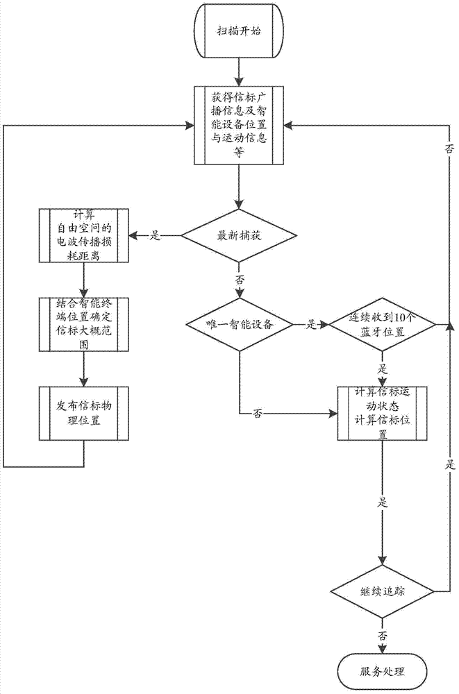
[0039] In order to describe the technical content of the present invention more clearly, further description will be given below in conjunction with specific embodiments.

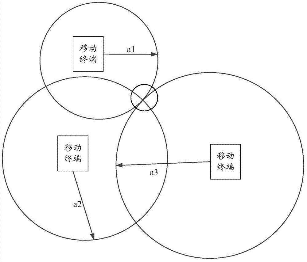
[0040] The present invention scans wireless beacons through the wireless receiving device of the smart handheld device that can obtain its own geographic location. Wireless beacons include but are not limited to: iBeacon, Bluetooth tags, WIFI APs, RFID tags, UWB tags, etc. The wireless beacon is near the smart handheld device and obtains the beacon RSSI strength;

[0041] All wireless beacons are identified by a unified UUID (Universally Unique Identifier, Universally Unique Identifier), and broadcast information at a certain frequency;

[0042] After any handheld device discovers the same wireless beacon, it will immediately and automatically send the handheld device's real-time geographic location coordinates, motion inertia and the found beacon RSSI strength to the background server

[0043] The server ...


PUM


Abstract

The invention relates to a system and a method for realizing positioning a wireless beacon geographic position, wherein the system comprises mobile equipment and a positioning server; the mobile equipment is used for acquiring wireless beacon signal strength changes and reporting the captured wireless bacon information as well as movement information and the geographic position information of the mobile equipment; the positioning server is used for calculating the geographic position and the movement attributes of the wireless bacon according to the wireless bacon information reported b the mobile equipment as well as the movement information and the geographic position of the mobile equipment. According to the system and the method for realizing positioning the wireless beacon geographic position disclosed by the invention, the relative geographic positions, movement inertia and the like of the wireless bacon are comprehensively calculated by adopting a triangular positioning algorithm and a movement inertia algorithm, and the business is timely reported through the platform of an intelligent terminal, so that the services of quick positioning, searching, tracking and the like of the mobile wireless bacon can be realized. The system is simple and convenient to apply, free of an extra base station and wide in scope of application.

Description

technical field [0001] The present invention relates to the technical field of wireless positioning, in particular to the technical field of wireless beacon positioning, and specifically refers to a system and method for realizing geographical location positioning of wireless beacons. Background technique [0002] There are many wireless signal tags (referred to as wireless beacons) in daily life, such as UWB (Ultra Wideband, ultra-wideband) tags, active RFID (Radio Frequency Identification, radio frequency identification) tags, iBeacon tags, ordinary BLE Bluetooth 4.0 tags, etc., These tags are generally very simple and compact, easy to carry, can work for a long time with low power consumption, and are suitable for short-distance broadcast signals. However, since beacons are often resource-constrained devices, they cannot obtain their own geographical location, upload their locations online, or report their location. At the same time, the positioning of traditional beacons...

Claims


Application Information

Patent Timeline
Patent Type & Authority Patents(China)
IPC IPC(8): G01S5/02
CPCG01S5/02
Inventor 林清洪宋世军陈俊宁连举敏
Owner 南通数融科技有限公司
Features
  • R&D
  • Intellectual Property
  • Life Sciences
  • Materials
  • Tech Scout
  • Unparalleled Data Quality
  • Higher Quality Content
  • 60% Fewer Hallucinations
Learn More