A Contour-Based Algorithm for Basemap Registration of Building Point Cloud Models

A point cloud model and building technology, applied in the field of computer vision, can solve problems such as weak spatial description ability, unfavorable practical application, and low degree of automation

Inactive Publication Date: 2018-03-30
BEIJING INST OF TECH SHENZHEN RES INST +1
View PDF4 Cites 2 Cited by
  • Summary
  • Abstract
  • Description
  • Claims
  • Application Information

AI Technical Summary

Problems solved by technology

The traditional point cloud model display form is that each building model is displayed independently, and the entire large scene is not combined, the spatial description ability is weak, and the characteristics of 3D display cannot be well utilized
Some geographic information systems (GIS) can also place 3D models on geographic platforms such as virtual earth for display, but the placement process requires a lot of manual interaction to achieve spatial alignment, and the entire process is very low in automation, which is not conducive to practical applications
Especially in the face of a large number of models that need to be registered, the huge interactive workload requires a lot of time and energy

Method used


Image

  • A Contour-Based Algorithm for Basemap Registration of Building Point Cloud Models
  • A Contour-Based Algorithm for Basemap Registration of Building Point Cloud Models
  • A Contour-Based Algorithm for Basemap Registration of Building Point Cloud Models

Examples


Embodiment 1

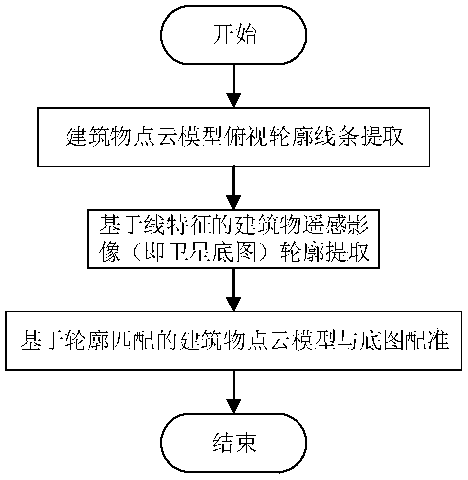
[0047] A method for registration of a building point cloud model base map based on contours, comprising the following steps:

[0048] Step 1. Boundary line extraction of building point cloud model

[0049] Step 1.1 Pose Estimation of Building Point Cloud Model

[0050] In this embodiment, the normal of the point cloud model is estimated using the open source point cloud data processing library PCL (Point Cloud Library), and the specific steps are as follows:

[0051] a) Use pcl's StatisticalOutlierRemoval filter to remove remote points;

[0052] b) Use the NormalEstimation method of pcl to estimate the normal vector of the point by fitting the cut plane through the point cloud information near the point;

[0053] Then the normals of all points are clustered at an angle θ, because the adjacent outer surfaces of conventional modern buildings have a mutually perpendicular spatial structure relationship, so there are three types of vectors that are approximately perpendicular to...

Embodiment 2

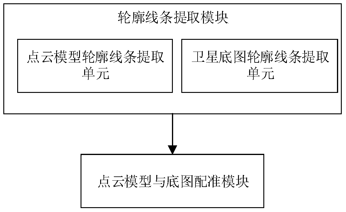
[0122] Such as image 3 Shown is a schematic structural diagram of a building point cloud model base map registration device based on contours. It can be seen from the figure that the device includes a contour line extraction module, a point cloud model and a base map registration module;

[0123] The contour line extraction module is used to extract the point cloud model and the contour lines of buildings in the satellite basemap;

[0124] The point cloud model and base map registration module is used to correctly place the point cloud model of the building on the satellite base map according to the point cloud model and the building outline lines in the satellite base map;

[0125] As preferably, the contour line extraction module includes a point cloud model contour line extraction unit and a satellite basemap contour line extraction unit; the point cloud model contour line extraction unit is used to extract the contour lines of buildings in the point cloud model, and the s...


PUM


Abstract

The invention relates to a building point cloud model and base map aligned method based on an outline, which belongs to the technical field of computer vision. The method comprises the steps of: performing structural analysis on the building point cloud model obtained by three-dimensional reconstruction, automatically detecting the posture of the current model, ultimately realizing normalization of coordinates of the point cloud model, and obtaining a point cloud overlooking outline drawing of a current building on the basis; performing outline analysis on a remote sensing image of an area in which a reconstructed building is positioned, and automatically detecting to obtain a base map outline; estimating structure turning points of the current building according to the outline of the reconstructed building, and then realizing space alignment of the point cloud model and a satellite base map by virtue of outline matching information, so as to obtain a mapping matrix from the point cloud model to the satellite base map and automatically realize the placement of the building point cloud model on the satellite base map. Compared with the prior art, the method has the advantages that the point cloud model and the base map can be accurately and automatically aligned, manual workload required by alignment is effectively reduced, and the alignment cost is reduced.

Description

Technical field: [0001] The invention belongs to the technical field of computer vision, and relates to a contour-based method for registering a point cloud model base map of a building, in particular to a point cloud model structure analysis, image contour extraction and matching of a building point cloud model and base map registration method. standard method. Background technique: [0002] In 3D reconstruction, a sequence of multi-angle images around buildings can be reconstructed to obtain a better point cloud model. However, these point cloud models are in independent coordinate systems and cannot directly form building complexes. However, the independent building model scene display ability is weak, and it cannot effectively express the spatial position relationship of the entire building group. Therefore, it is necessary to organically integrate the point cloud models of independent buildings in the building complex into a whole, so as to realize the intuitive displ...

Claims


Application Information

Patent Timeline
Patent Type & Authority Patents(China)
IPC IPC(8): G06T3/00
CPCG06T3/0075
Inventor 黄华刘洪张磊
Owner BEIJING INST OF TECH SHENZHEN RES INST
Why Eureka
Try Eureka