GPS auxiliary positioning method and system operating in intelligent hand-held data acquisition terminal

A technology of data acquisition terminal and auxiliary positioning system, which is applied in the field of GPS auxiliary positioning method and system, and can solve the problems of poor positioning accuracy, large positioning accuracy error of GPS equipment and high precision requirements, and difficulty in achieving accurate positioning, etc.

Inactive Publication Date: 2015-11-25
ELECTRIC POWER RESEARCH INSTITUTE OF STATE GRID SHANDONG ELECTRIC POWER COMPANY +1
View PDF5 Cites 9 Cited by
  • Summary
  • Abstract
  • Description
  • Claims
  • Application Information

AI Technical Summary

Problems solved by technology

Difficult to achieve more precise positioning
And because the anti-interference is not strong, the positioning accuracy of civilian GPS is even worse in cities full of tall buildings
[0004] In order to solve the contradiction between the large positioning accuracy error of GPS equipment and the high precision requirements of GPS system coordinates in some industries

Method used


Image

  • GPS auxiliary positioning method and system operating in intelligent hand-held data acquisition terminal
  • GPS auxiliary positioning method and system operating in intelligent hand-held data acquisition terminal
  • GPS auxiliary positioning method and system operating in intelligent hand-held data acquisition terminal

Examples


Embodiment Construction

[0042] The present invention is described in detail below in conjunction with accompanying drawing:

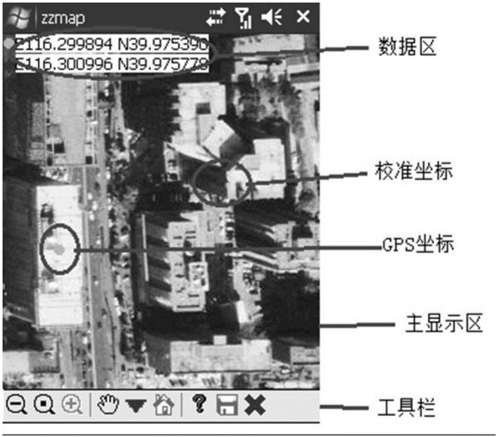
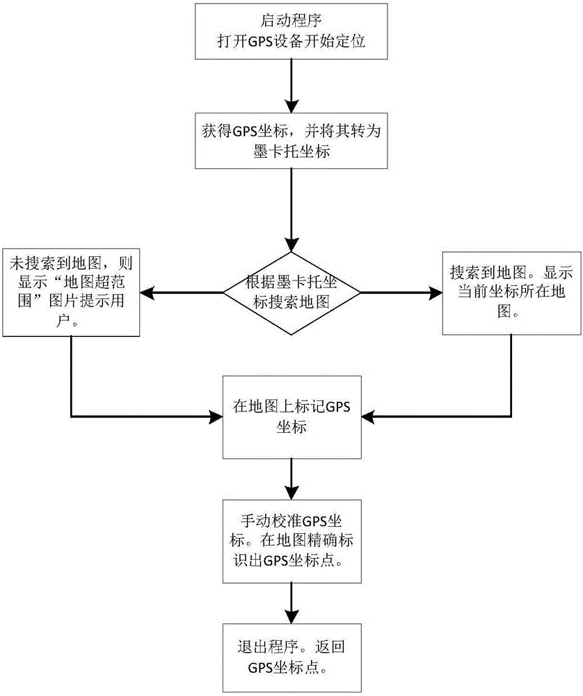
[0043] This development aims at accurately locating the actual coordinates of faulty electric meters in the electric power industry, because there are errors in the coordinates returned directly by GPS, an assisted GPS positioning system has been developed. The way to use this system is to first obtain the GPS system coordinates through the GPS satellite positioning system, and mark the GPS system coordinates on the map on the screen of the handheld device, such as figure 1 As shown, it is the user interface of the device auxiliary positioning program zzmap.exe. The map in the handheld device is downloaded in advance and stored in the TF card. The GPS system coordinate point in the figure is the position on the map after the coordinates returned by the GPS to the device after conversion. It can be seen that there is a difference from the actual position. At this point, the ap...


PUM


Abstract

The invention discloses a GPS auxiliary positioning method and system operating in an intelligent hand-held data acquisition terminal. The method comprises the following steps: obtaining GPS system coordinates through the intelligent hand-held data acquisition terminal; converting the obtained GPS system coordinates into Baidu map coordinates; positioning coordinate points on a map and marking the current GPS system coordinate points on the map; and correcting the coordinates positioned on the map in the step 3 through a man-machine interaction manner, and keeping and displaying the corrected coordinate values. The research and development of the GPS auxiliary positioning system effectively solve the problem of ticket mis-giving. Accurate positioning and geographical identification effect of a satellite map can allow law enforcement personnel to find fault meters conveniently, and thus law enforcement efficiency is improved.

Description

technical field [0001] The invention relates to the field of geographic coordinate positioning, in particular to a GPS-assisted positioning method and system running on an intelligent handheld data collection terminal. Background technique [0002] In the field of GPS positioning, the use of GPS is divided into military signals and civilian signals. At present, the GPS devices used by ordinary people are civilian signals. Due to the influence of the U.S. defense policy, the civilian GPS system is deliberately interfered by the U.S., and there are certain errors. [0003] As the civilian GPS market continues to grow, it has directly created huge economic benefits for the United States. The United States' support for civilian GPS is also gradually increasing - from the lifting of the selective availability restriction (SA: Selective Availability) that reduces the positioning accuracy of C / A codes, to the launch of new satellites to increase GPS civilian signals. But despite...

Claims


Application Information

Patent Timeline
IPC IPC(8): G01S19/42G01S19/40
CPCG01S19/42G01S19/40
Inventor 郭红霞王者龙荆臻任大为王兆军
Owner ELECTRIC POWER RESEARCH INSTITUTE OF STATE GRID SHANDONG ELECTRIC POWER COMPANY
Why Eureka
Try Eureka