Automatic cruise algorithm for tailing pond dry beach length and beach crest elevation

An automatic cruise, tailings pond technology, applied in surveying and navigation, altitude/level measurement, measurement devices and other directions, can solve the problem of low accuracy of manual measurement

Inactive Publication Date: 2017-04-26
XIAN TECHNOLOGICAL UNIV
View PDF4 Cites 0 Cited by
  • Summary
  • Abstract
  • Description
  • Claims
  • Application Information

AI Technical Summary

Problems solved by technology

[0005] The purpose of the present invention is to provide an automatic cruising algorithm for tailings reservoir dry beach length and beach top elevation, which solves the problem of low accuracy of manual measurement under environmental constraints in the prior art

Method used


Image

  • Automatic cruise algorithm for tailing pond dry beach length and beach crest elevation
  • Automatic cruise algorithm for tailing pond dry beach length and beach crest elevation
  • Automatic cruise algorithm for tailing pond dry beach length and beach crest elevation

Examples


Embodiment Construction

[0075] The present invention will be described in detail below in conjunction with the accompanying drawings and specific embodiments.

[0076] The automatic cruise algorithm for tailings reservoir dry beach length and beach top elevation includes the following steps:

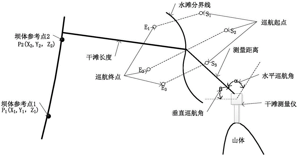
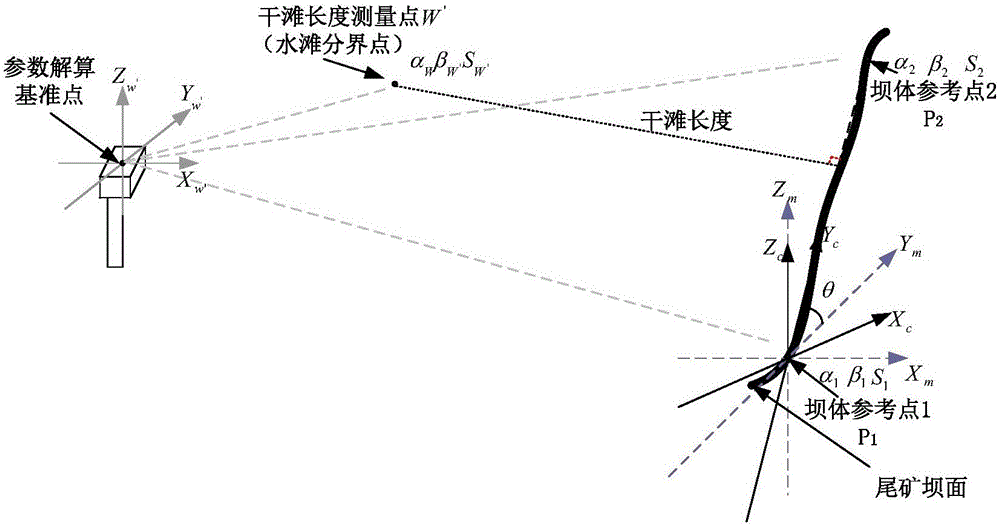
[0077] Step 1. Place the dry beach measuring instrument at a high point near the tailings pond, measure and record the elevation of the dry beach measuring instrument;

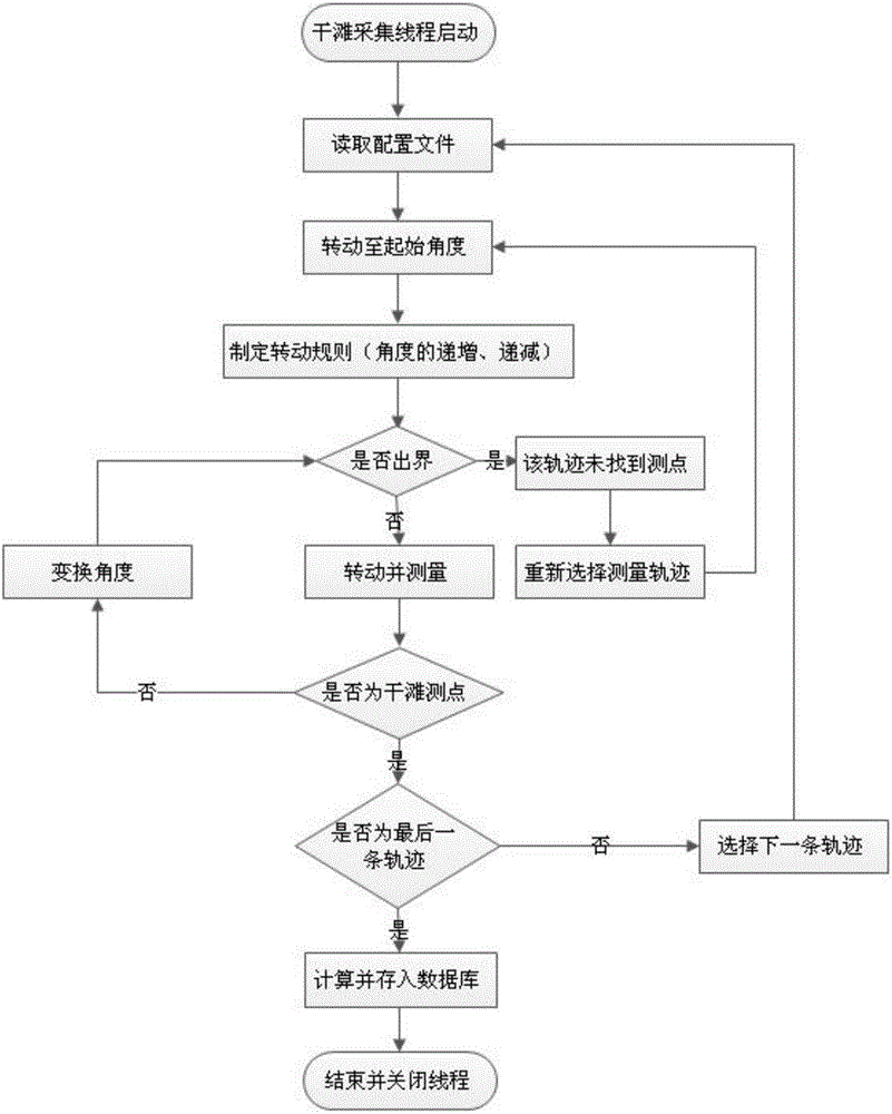
[0078] Step 2. Preset the dry beach length cruise track and the beach top elevation cruise track, find the dry beach length measurement point according to the dry beach length cruise track, and find the beach top elevation measurement point according to the beach top elevation cruise track;

[0079] Step 3. Record the distance from the dry beach measuring instrument to the dry beach length measuring point, as well as the horizontal cruising angle and vertical cruising angle between the dry beach measuring instrument and the dry beach length mea...


PUM


Abstract

The invention relates to an automatic cruise algorithm for tailing pond dry beach length and beach crest elevation. The method includes the steps of: 1. placing a dry beach measuring instrument at a high spot near a tailing pond, measuring and recording the elevation of the dry beach measuring instrument; 2. presetting a dry beach length cruise track and a beach crest elevation cruise track, seeking a dry beach length measurement point according to the dry beach length cruise track, and seeking a beach crest elevation measurement point according to the beach crest elevation cruise track; 3. recording the distance between the dry beach measuring instrument and the dry beach length measurement point, a horizontal cruise angle and a vertical cruise angle; selecting two reference points on a dam body, recording the distances from the dry beach measuring instrument to the two dam body reference points, horizontal cruise angles and vertical cruise angles, and calculating the dry beach length; and 4. recording the distance between the dry beach measuring instrument and the beach crest elevation measurement point, a horizontal cruise angle and a vertical cruise angle, and calculating the beach crest elevation. The method solves the problems of low accuracy of manual measurement because of environmental constraints in the prior art.

Description

technical field [0001] The invention belongs to the technical field of mining and metallurgy safety monitoring methods, and relates to an automatic cruising algorithm for tailings reservoir dry beach length and beach top elevation. Background technique [0002] Tailings dry discharge is a tailings disposal process that has gradually emerged in China in recent years. It means that the tailings slurry output from the beneficiation process is concentrated in multiple stages, and then dehydrated by high-efficiency dehydration equipment such as dehydration vibrating screens to form a low-water content, Slag that is easy to precipitate and solidify, easy to transport and easy to store. Dry discharge of tailings can improve the utilization rate of tailings and reduce environmental pollution. Now the country has expressly required that dry discharge of tailings must be carried out on the slurry. [0003] The tailings pond refers to the place where the tailings dam intercepts the mo...

Claims


Application Information

Patent Timeline
Patent Type & Authority Applications(China)
IPC IPC(8): G01C11/00G01C5/00G01C3/00
CPCG01C11/00G01C3/00G01C5/00
Inventor 王建国张诚李磊高美娟
Owner XIAN TECHNOLOGICAL UNIV
Why Eureka
Try Eureka