System and method for map construction aiming at communication failure area of earthquake area

A map construction and area technology, applied in control/adjustment systems, maps/plans/charts, 3D modeling, etc., can solve problems such as inability to detect disaster-affected area information in time, poor search and rescue timeliness, and shortening of detection time.

Active Publication Date: 2017-06-27
青岛未来说教育科技有限公司
View PDF4 Cites 12 Cited by
  • Summary
  • Abstract
  • Description
  • Claims
  • Application Information

AI Technical Summary

Problems solved by technology

[0004] In order to solve the problem that the existing technology cannot timely detect the information of the disaster-affected area and the timeliness of search and rescue is poor, the present invention interconnects the aerial detection device and the land detection device through independent communication, and provides a map construction system for the communication failure area of ​​the earthquake-stricken area. Can quickly obtain post-disaster maps and rescue information, effectively save manpower, shorten detection time, and significantly improve rescue efficiency

Method used


Image

  • System and method for map construction aiming at communication failure area of earthquake area
  • System and method for map construction aiming at communication failure area of earthquake area
  • System and method for map construction aiming at communication failure area of earthquake area

Examples


Embodiment

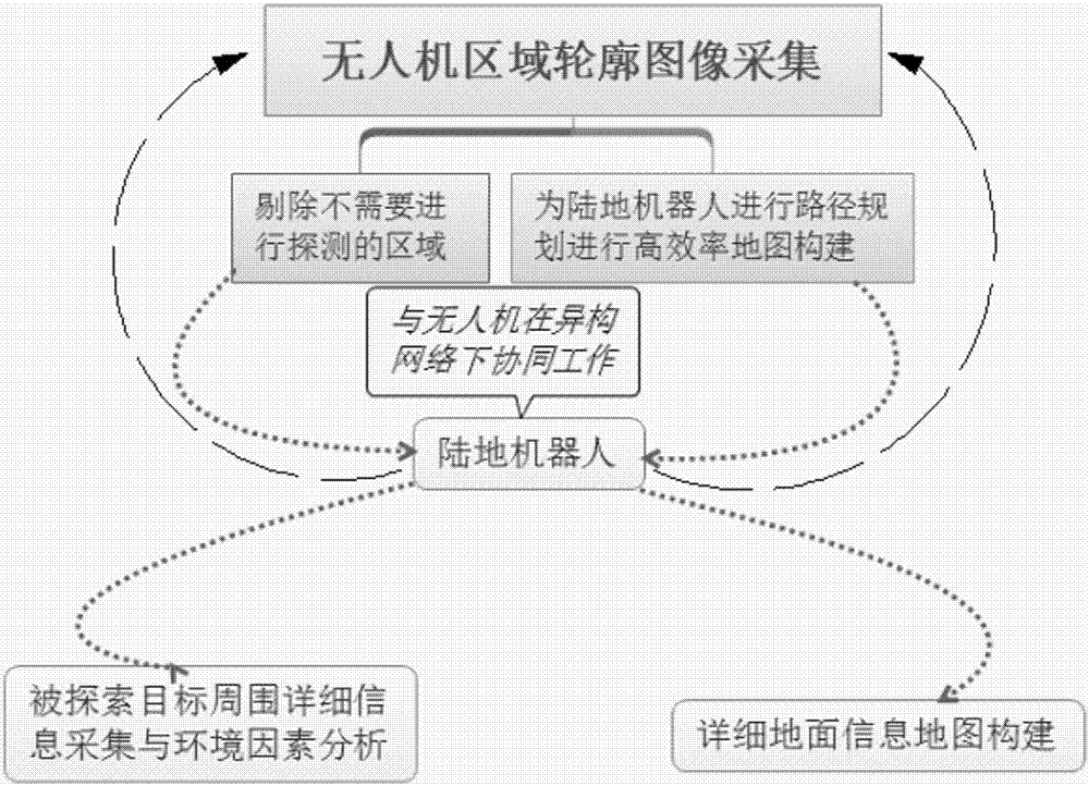
[0028] This embodiment is mainly aimed at the rapid real-time map intelligent construction of the lost contact area after the disaster, helping rescuers to navigate and rescue, and invented a map construction system and its construction method for the communication failure area in the earthquake disaster area. The device and operation flow chart are as follows figure 1 as shown,

[0029] A map construction system for communication failure areas in earthquake-stricken areas, including an air detection device and a land detection device; the air detection device includes an aircraft, a binocular vision module, a map revision module and an air navigation module; the land detection device It includes a carrier, a land sensing module, a map building module and a ground navigation module; wherein, the aerial detection device and the land detection device are connected through the Zigbee communication module.

[0030] In the aerial detection device, the aircraft is equipped with a bi...


PUM


Abstract

The present invention discloses a system for map construction aiming at a communication failure area of an earthquake area, belonging to the post-disaster reconstruction device field. The device comprises an air detection device and a land detection device; the air detection device comprises an aircraft, a binocular visual sense module, a map revision module and an air navigation module; the land detection device comprises a carrier, a land sensing module, a map construction module and a ground navigation module, wherein the air detection device is in communication connection with the land detection device through a zig bee communication module. The air detection device and the land detection device are interconnected through autonomous communication to rapidly obtain a post-disaster map and information required rescuing so as to effectively save manpower, shorten the detection time and substantially improve the rescue efficiency.

Description

technical field [0001] The invention belongs to the field of post-disaster reconstruction devices, and in particular relates to a map construction system and a construction method for communication failure areas in earthquake-stricken areas. Background technique [0002] In recent years, frequent earthquake disasters at home and abroad have brought serious casualties and economic losses to the society. When a disaster occurs, the communication base station is destroyed, which interrupts the communication in the disaster area and becomes an isolated "information island". Under such conditions, it is difficult to carry out rescue work. According to statistics, the repair work of all emergency communications in the Lushan earthquake in Sichuan lasted 56 hours. Not only that, but also 60 hours have passed since the Chengdu headquarters in the Wenchuan earthquake from the occurrence of the earthquake to the first news of the epicenter. This period of time when surveying and resc...

Claims


Application Information

Patent Timeline
Patent Type & Authority Applications(China)
IPC IPC(8): G09B29/00G05D1/10G06T17/05
CPCG05D1/101G06T17/05G09B29/005
Inventor 王兴伟潘雨昂刘欣凯
Owner 青岛未来说教育科技有限公司
Why Eureka
Try Eureka