Tight combination method for calculating pseudo range/pseudo range rate by using Doppler velocimeter

A Doppler velocimeter and pseudorange rate technology, applied in the field of navigation, can solve problems such as loss of navigation ability, and achieve the effect of high-precision navigation

Active Publication Date: 2017-08-04
中联天通科技(北京)有限公司
View PDF8 Cites 12 Cited by
  • Summary
  • Abstract
  • Description
  • Claims
  • Application Information

AI Technical Summary

Benefits of technology

This technology allows for precise measurement on movement carriers based upon their pseudo distance from an orbiting reference point called LOS (Line Of Sight). By combining this data with both GNSS signals or other navigational systems like GLONASS, it becomes possible to achieve very accurate location tracking over large areas without any external references such as ground markers.

Problems solved by technology

This patented technology allows for accurate measurements on vehicles at different speeds while avoiding any issues that may affect their navigational capabilities during interruptions or collisions between them.

Method used


Image

  • Tight combination method for calculating pseudo range/pseudo range rate by using Doppler velocimeter
  • Tight combination method for calculating pseudo range/pseudo range rate by using Doppler velocimeter
  • Tight combination method for calculating pseudo range/pseudo range rate by using Doppler velocimeter

Examples


Embodiment Construction

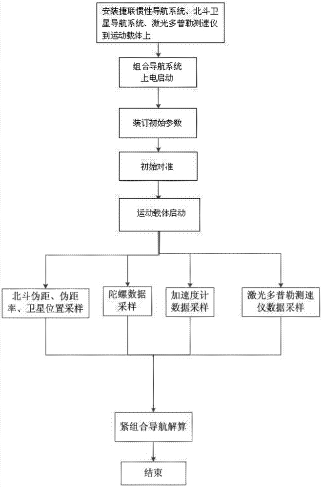
[0056] Such as figure 1 Shown, the present invention is divided into the following steps:

[0057] Step 1. Install the strapdown inertial navigation system, laser Doppler velocimeter, and Beidou satellite navigation system on the moving carrier to form an integrated navigation system for the moving carrier. The integrated navigation system is powered on and started;

[0058] Step 2. After the integrated navigation system is powered on and started, the longitude, latitude, and height of the initial position of the moving carrier received by the Beidou satellite navigation system are used as the initial position parameters of the strapdown inertial navigation system, and the initial position parameters are bound to the strapdown inertial navigation system. in the system's navigation computer;

[0059] Step 3. The moving carrier remains stationary for 5 minutes, and the initial alignment is performed according to the initial position parameters of the binding; the specific metho...


PUM


Abstract

The invention discloses a tight combination method for calculating a pseudo range/pseudo range rate by using a Doppler velocimeter. The method comprises: step 1, installing a strapdown inertial navigation system, a laser Doppler velocimeter, and a Beidou satellite navigation system at a moving carrier, and electrifying the combined navigation system for starting up; step two, carrying out initial position parameter binding; step three, keeping the moving carrier to be still for five minutes, carrying out initial alignment to obtain an initial attitude angle; step four, starting a tight combination mode and starting the moving carrier; and step five, carrying out calculation to obtain a pseudo range value and a pseudo range rate value, and carrying out tight combination navigation by using differences between the pseudo range value and pseudo range rate value and pseudo range and pseudo range rate values outputted by a Beidou satellite navigation system as observation values of the combined navigation system. According to the invention, tight combination with the Beidou satellite navigation system is carried out by using the pseudo range value and pseudo range rate value calcualtd by the laser Doppler velocimeter and function complementation is realized; and the pseudo range value and pseudo range rate value of the moving carrier are deduced based on the location of the moving carrier and the Beidou satellite, so that high-precision navigation is realized.

Description


Claims


Application Information

Patent Timeline
Owner 中联天通科技(北京)有限公司
Why Eureka
Try Eureka