A road construction level meter and measurement method based on agps positioning

A GPS positioning and measurement method technology, applied in the direction of measuring devices, measuring inclination, instruments, etc., can solve problems such as settlement, error, difficult long-distance accurate measurement, etc.

Active Publication Date: 2020-07-17
彭哲 +1
View PDF8 Cites 0 Cited by
  • Summary
  • Abstract
  • Description
  • Claims
  • Application Information

AI Technical Summary

Problems solved by technology

[0003] In the process of road construction, it is necessary to consider the requirements of different vehicle traffic properties on the road slope. For example, in the process of high-standard expressway construction, it is necessary to keep the slope of the road surface from three degrees. In plain construction, it is necessary to maintain the level of the road as much as possible. , the traditional way is to monitor the angle of the road surface through the observation of the level meter. In practical application, this method is only suitable for observation within the distance range with clear vision. The cold and warm currents lead to inconsistent air density and light refraction, which will also lead to errors. Not only that , due to the heavy weight of the observation equipment, it is difficult to perform long-distance accurate measurement. After placement, it is easy to cause settlement due to subsidence of the foundation, which will even cause measurement deviation. Therefore, a method is needed to measure the slope between the two ends of a long road section and avoid settlement errors. Tool of

Method used


Image

  • A road construction level meter and measurement method based on agps positioning
  • A road construction level meter and measurement method based on agps positioning
  • A road construction level meter and measurement method based on agps positioning

Examples


Embodiment Construction

[0039] The following will clearly and completely describe the technical solutions in the embodiments of the present invention with reference to the accompanying drawings in the embodiments of the present invention. Obviously, the described embodiments are only some, not all, embodiments of the present invention. Based on the embodiments of the present invention, all other embodiments obtained by persons of ordinary skill in the art without making creative efforts belong to the protection scope of the present invention.

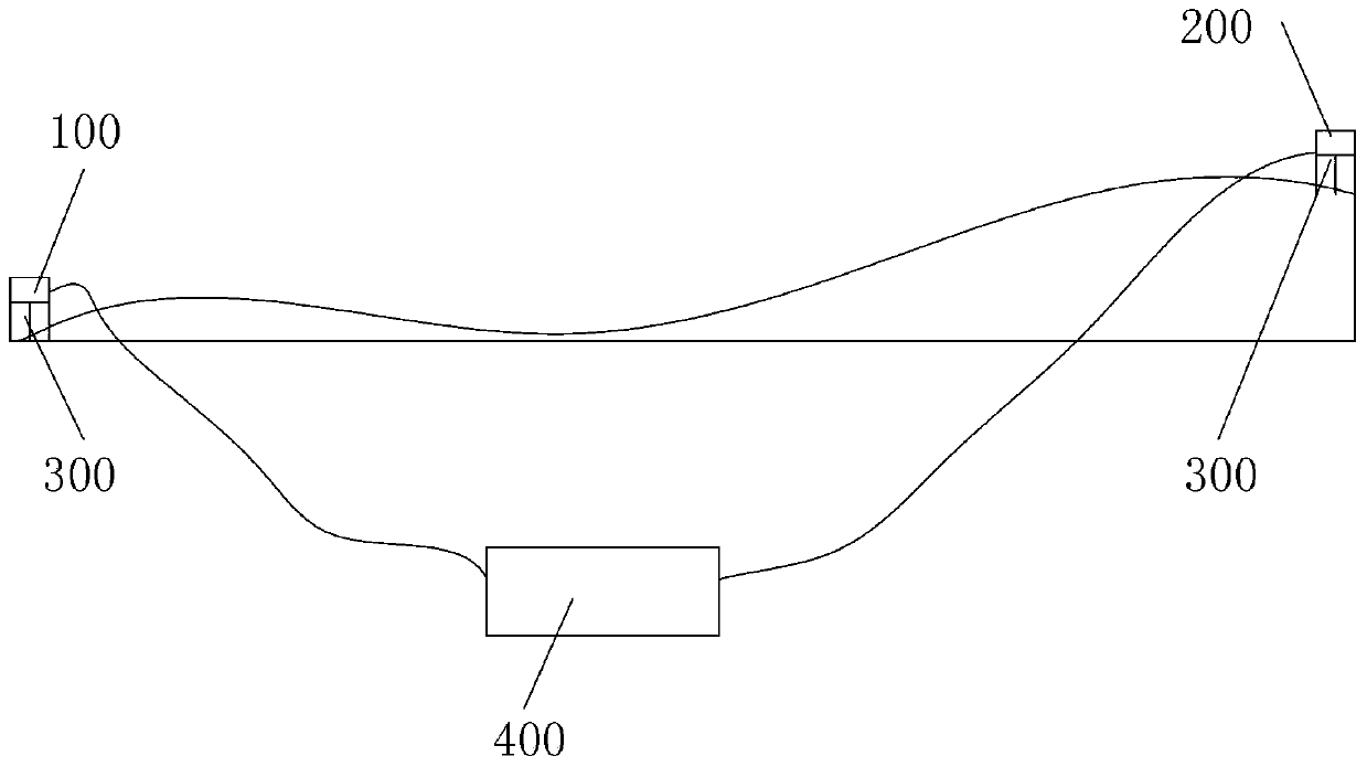
[0040] like Figure 1-6 As shown, the present invention is a road construction level based on AGPS positioning, including a first receiver 100 and a second receiver 200 respectively located at both ends of the measuring road section, and the first receiver 100 and the second receiver 200 communicate through equidistant communication. an optical cable connected to the resolver 300;

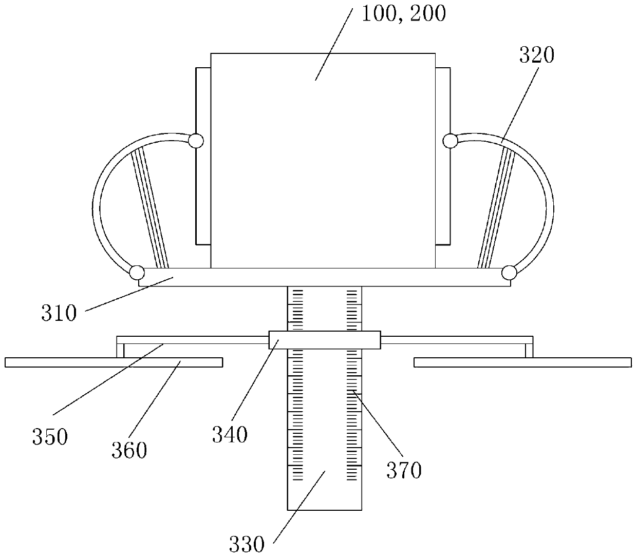
[0041] Both the first receiver 100 and the second receiver 200 are placed on ...


PUM


Abstract

The invention discloses a road construction level device on the basis of AGPS positioning and a measurement method. The level device includes a first receiver and a second receiver, which are connected to a resolver via optical cables in order to acquire a series of positioning time-GPS positioning height information and positioning time-cellular mobile positioning height information in unit time;then a fixing frame settlement curve is acquired; the initial point of the fixing frame settlement curve is set as a height position of a road measurement point. By means of GPS, two ends of a road are positioned; before the GPS positioning, a cellular mobile network is used for crude positioning in order to acquire an approximate position; then according to positioning satellite map, selecting aproper positioning satellite for localization; during the process, the cellular mobile network synchronously works, so that height values obtained through the two positioning process are fitted withthe correspondence of positioning to obtain a function curve; furthermore, comparison is carried out to obtain a precise height value of the measurement point. The slope of the road is acquired by theheights of the two end points without limitation by visibility range.

Description

technical field [0001] The invention relates to the field of road construction surveying and mapping, in particular to an AGPS positioning-based road construction level and a measuring method. Background technique [0002] The road accompanies human activities and promotes social progress and development. It is a symbol of historical civilization and a sign of scientific progress. Primitive roads are footpaths trampled by man. In the future, better roads will be required, soil will be taken to fill the pits, and trees will be erected to cross the stream to facilitate traffic. [0003] In the process of road construction, it is necessary to consider the requirements of different vehicle traffic properties on the road slope. For example, in the process of high-standard expressway construction, it is necessary to keep the slope of the road surface from three degrees. In plain construction, it is necessary to maintain the level of the road as much as possible. , the traditiona...

Claims


Application Information

Patent Timeline
Patent Type & Authority Patents(China)
IPC IPC(8): G01C9/00
CPCG01C9/00
Inventor 刘柯颖杨蕾璟司涛彭哲陈白露蒋悦张文烜
Owner 彭哲
Why Eureka
Try Eureka