Clustering map creating method and repositioning method based on matching of clustering map and position descriptor

A clustering and map technology, applied in character and pattern recognition, instruments, computing, etc., can solve the problems of large scene changes, many dynamic objects, and difficulties in autonomous relocation of unmanned vehicles created by maps

Active Publication Date: 2019-08-02
HARBIN INST OF TECH SHENZHEN GRADUATE SCHOOL
View PDF9 Cites 27 Cited by
  • Summary
  • Abstract
  • Description
  • Claims
  • Application Information

AI Technical Summary

Problems solved by technology

[0006] In order to solve the above technical problems, one of the purposes of the present invention is to provide a method for creating a cluster map, which solves the problem that the cur

Method used


Image

  • Clustering map creating method and repositioning method based on matching of clustering map and position descriptor
  • Clustering map creating method and repositioning method based on matching of clustering map and position descriptor
  • Clustering map creating method and repositioning method based on matching of clustering map and position descriptor

Examples


Embodiment Construction

[0064] In order to make the object, technical solution and advantages of the present invention more clear, the present invention will be further described in detail below in conjunction with the examples, but the protection scope of the present invention is not limited to the following specific examples.

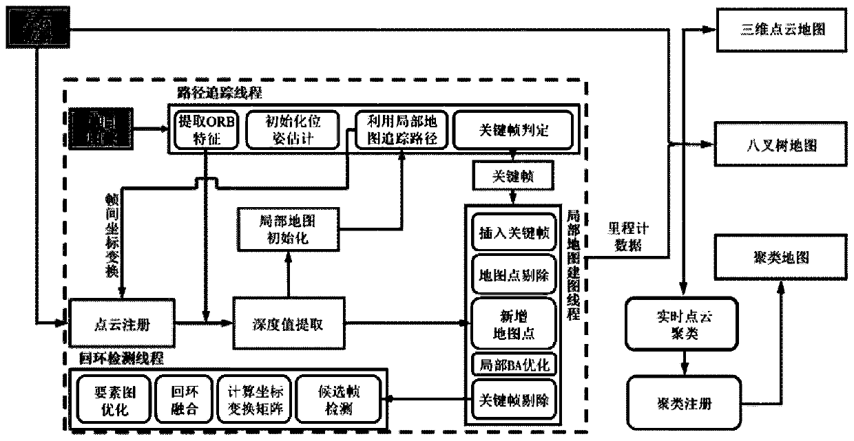
[0065] like figure 1 As shown, a method for creating a cluster map includes the following steps:

[0066] Step 1. Create the cluster map and provide positioning information through the three-dimensional vision-laser SLAM system framework, the three-dimensional vision-laser SLAM system framework includes a path tracking thread, a local map construction thread, and a loop detection thread; in the path In the tracking thread, the pose of the corresponding lidar is obtained through the point cloud registration module, and the monocular vision image and the 3D laser point cloud data are fused, and then the depth of the corresponding visual feature point is extracted from the 3D l...


PUM


Abstract

The invention discloses a clustering map creating method and a repositioning method based on matching of a clustering map and a position descriptor. The invention provides a three-dimensional visual laser SLAM system with a complete system structure and a cluster map creating method. The repositioning method of the unmanned vehicle is designed based on the clustering map and the position descriptor. A clustering map consistent with the scale of a real scene is created for an urban dynamic environment. A position descriptor used for describing point cloud clustering position characteristics isdesigned, and reliable repositioning of the unmanned vehicle in the urban environment is achieved through matching and screening of the position descriptor. By ignoring the change of the shape of a single object and focusing on the mutual position relation between different objects, the repositioning method provided by the invention can effectively cope with the adverse change of various scene conditions, realizes higher repositioning success rate, and has wider application prospect and higher research value.

Description

technical field [0001] The invention relates to the field of positioning of unmanned equipment, in particular to a clustering map creation method and a relocation method based on clustering maps and position descriptor matching. Background technique [0002] In the field of drones and unmanned vehicles, SLAM technology (that is, "simultaneous positioning and map construction") can provide position and map information for unmanned vehicles in unknown environments, just like the human perception system. Therefore, in many research fields of autonomous driving, SLAM technology will be used to provide technical support for the active pathfinding and dynamic obstacle avoidance of unmanned vehicles. In the relevant application scenarios of automatic driving, a problem that often needs to be solved is called the "kidnapping problem". This problem requires that the self-driving car still be able to pass the current environmental information and For the existing environmental map, r...

Claims


Application Information

Patent Timeline
IPC IPC(8): G06K9/62G06K9/00
CPCG06V20/39G06F18/23
Inventor 陈浩耀潘志琛姜欣刘云辉
Owner HARBIN INST OF TECH SHENZHEN GRADUATE SCHOOL
Why Eureka
Try Eureka