Airborne SAR (Synthetic Aperture Radar) high-resolution tomography method

A tomography, high-resolution technology, used in the reflection/re-radiation of radio waves, the use of re-radiation, measurement devices, etc.

Active Publication Date: 2019-11-22
XIDIAN UNIV
View PDF7 Cites 10 Cited by
  • Summary
  • Abstract
  • Description
  • Claims
  • Application Information

AI Technical Summary

Problems solved by technology

[0004] However, the above method can only obtain high-resolution tomographic imaging results when the baselines of different passes are not significantly different, and the coherent speckle noise in the SAR image is not obvious. , and when there is coherent speckle noise in the SAR image, the resolution of the tomography is reduced

Method used


Image

  • Airborne SAR (Synthetic Aperture Radar) high-resolution tomography method
  • Airborne SAR (Synthetic Aperture Radar) high-resolution tomography method
  • Airborne SAR (Synthetic Aperture Radar) high-resolution tomography method

Examples


Embodiment 1

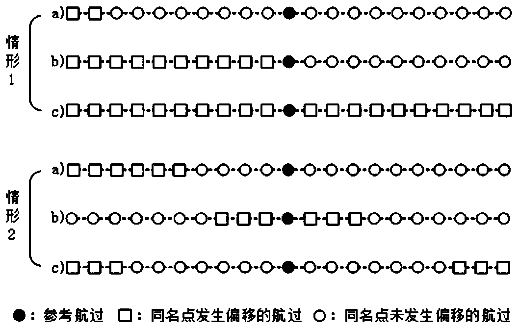
[0076] At present, the existing SAR tomography method is under the scenario of multiple voyages of the baseline, large differences in observation angles, and large influence of coherent speckle noise, because there is a serious deterioration of the elevation to the side lobe, and all homologous points in the SAR image cannot Inaccurate deflection of deflection when accurate registration and elevation focus are performed simultaneously at the same pixel (pixel of the same name), resulting in a decrease in tomographic resolution.

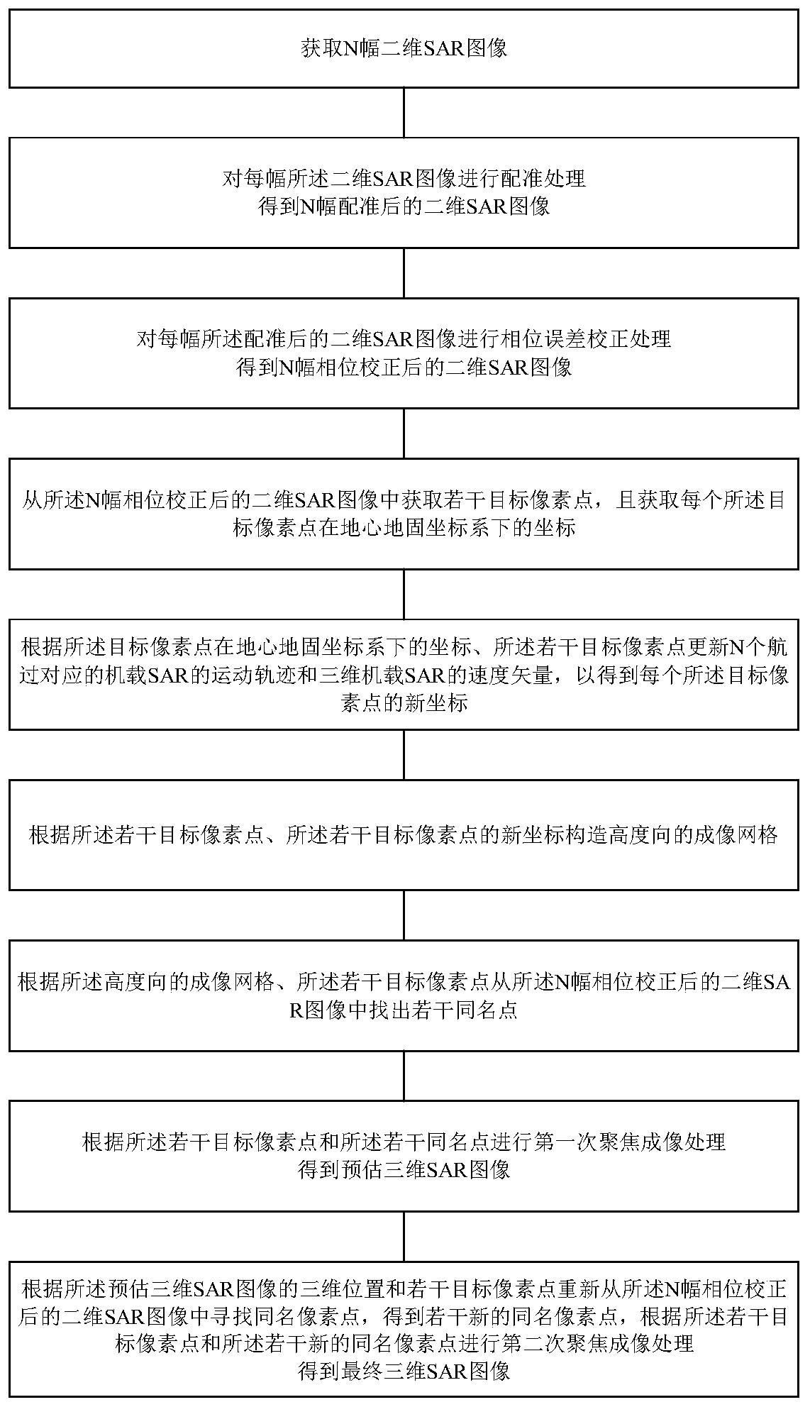
[0077] Based on the above problems, please refer to figure 1 , figure 1 It is a schematic flowchart of an airborne SAR high-resolution tomography method provided by an embodiment of the present invention. This embodiment provides an airborne SAR high-resolution tomography method, the method comprising:

[0078] Step 1. Obtain N pieces of two-dimensional SAR images, where N is an integer greater than 1;

[0079] Step 2, performing registration proce...


PUM


Abstract

The invention discloses an airborne SAR high-resolution tomography method. The method comprises the following steps: acquiring a two-dimensional SAR image; registering the two-dimensional SAR image toobtain a registered two-dimensional SAR image; performing phase error correction on the registered two-dimensional SAR image to obtain a two-dimensional SAR image after phase correction; obtaining atarget pixel point and a coordinate of the target pixel point in a geocentric earth-fixed coordinate system from the two-dimensional SAR image after phase correction; constructing an imaging grid in the elevation direction according to the target pixel points and the coordinates; finding out homonymous pixel points from the two-dimensional SAR image after phase correction according to the imaginggrid in the elevation direction and the target pixel points; and performing focusing imaging according to the target pixel points and the homonymous pixel points to obtain a three-dimensional SAR image. According to the invention, tomography is carried out on different navigations, so that the problem of serious deterioration of elevation direction sidelobes when vertical effective baselines are distributed unevenly is solved, and the defect of inaccurate declination during elevation direction focusing is also avoided, so that high-resolution tomography is realized.

Description

technical field [0001] The invention belongs to the technical field of radar signal processing, and in particular relates to an airborne SAR high-resolution tomographic imaging method. Background technique [0002] Tomosynthetic aperture radar imaging technology is a cutting-edge technology in modern radar remote sensing measurement. The essence of this imaging technology is to make multiple observations of the same scene or ground object from different perspectives in the elevation direction. A single observation forms a two-dimensional synthetic aperture radar image, and multiple observations form a synthetic aperture in the elevation direction, focusing along the elevation direction to achieve elevation upward scatterer resolution, thereby realizing high-resolution three-dimensional imaging of the target. Compared with two-dimensional SAR images, tomosynthetic aperture radar imaging technology can accurately estimate the height position and scattering intensity of differ...

Claims


Application Information

Patent Timeline
Patent Type & Authority Applications(China)
IPC IPC(8): G01S13/90
CPCG01S13/9005G01S13/9004
Inventor 李真芳唐繁乙解金卫王志斌
Owner XIDIAN UNIV
Why Eureka
Try Eureka