Spatial Information Spatiotemporal Big Data Constraint Expression Method

A technology of spatial information and expression method, applied in geographic information database, structured data retrieval, special data processing applications, etc., can solve the problems affecting the accuracy of spatiotemporal big data fusion model, complex spatiotemporal data structure, etc.

Active Publication Date: 2020-11-03
EAST CHINA NORMAL UNIV
View PDF10 Cites 0 Cited by
  • Summary
  • Abstract
  • Description
  • Claims
  • Application Information

AI Technical Summary

Problems solved by technology

[0003] In recent years, spatio-temporal data has a complex structure and diverse sources. Integration, cleaning and conversion of spatio-temporal data from different sources is crucial for spatio-temporal big data technology processing and application research. Existing spatio-temporal data mainly come from GPS, remote sensing and sensors, etc. Devices, the data format and data form generated by each device are different, and spatio-temporal data is no longer limited to the traditional data form, especially the vigorous development of the Internet, which also contains rich multimedia data such as text, audio and video. Spatio-temporal data, and spatio-temporal data always produce and function in a certain time and space, and often only become prominent when combined with the visual expression of environmental (geographical) elements, and only the data obtained at the same time can be collected and unified. Spatiotemporal big data has research and application value. At the same time, there are distortions or losses in the process of spatiotemporal data observation. After the spatiotemporal benchmark is unified, additional errors will still be brought in time series analysis, which will affect the accuracy of spatiotemporal big data fusion models. , therefore, the present invention proposes a spatial information space-time big data constraint expression method to solve the problems existing in the prior art

Method used


Image

  • Spatial Information Spatiotemporal Big Data Constraint Expression Method
  • Spatial Information Spatiotemporal Big Data Constraint Expression Method
  • Spatial Information Spatiotemporal Big Data Constraint Expression Method

Examples


Embodiment Construction

[0031] In order to make the technical means, objectives, and effects of the invention easy to understand, the present invention will be further described below in conjunction with specific embodiments.

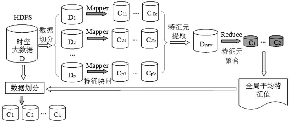
[0032] according to figure 1 , 2 , 3, and 4, this embodiment provides a method for expressing spatial information spatiotemporal big data constraints, and the specific steps are as follows:

[0033] Step 1: Data Collection

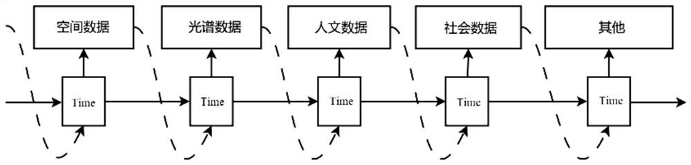
[0034] Collect measurable and non-measurable data with temporal and spatial relationships from the global navigation satellite system GNSS, space-ground integrated remote sensing RS, 3D geographic information system 3DGIS, Internet of Things, and computers to form spatiotemporal big data, including temporal data, spatial Data, spectral data, human data and social data, GNSS is instantaneous spatio-temporal data, directly obtains geographic information, has high-precision important indicators, and remote sensing RS data interprets the size, shape, spatial...


PUM


Abstract

The invention discloses a spatial information space-time big data constraint expression method. The method comprises the following steps of data acquisition, construction of a vector and grid compatible data structure, data comprehensive expression, data correction, space-time benchmark unification, space-time big data constraint and space-time big data cleaning and updating. According to the method, a multi-dimensional heterogeneous basic data organization unit and an organization system taking a topological relation between parent and child regions as a relation are established through normalization fusion of data structures; the organization modes of the layered spatiotemporal data and the framing spatiotemporal data are conveniently and comprehensively expressed; the space-time big data modeling method has the advantages that data can be highlighted conveniently, time synchronization and space benchmark unification in the space-time big data are achieved, space-space-ground integrated fusion of GNSS and the Internet of Things is achieved, theoretical support is provided for high time resolution and high space resolution. Meanwhile, a data constraint mechanism is formed before space-time big data modeling, deviation is removed conveniently, and precision is improved.

Description

technical field [0001] The invention relates to the field of data constraint expression methods, in particular to a method for expressing spatial information spatiotemporal big data constraints. Background technique [0002] In recent years, technologies and applications such as the Internet of Things, cloud computing, smart cities, big data, and artificial intelligence have emerged continuously, and the generated data urgently needs accurate analysis and processing. At the same time, the global navigation satellite system, remote sensing satellites, etc. The spatio-temporal big data needs to improve the universality and application quality of its fusion model, and then integrate the spatio-temporal data generated by earth observation with public media data (such as city cameras, social media, personal activities, etc.) Credible modeling, big data refinement, and domain-oriented large-scale applications have become common hotspots in the field of spatial information technolo...

Claims


Application Information

Patent Timeline
Patent Type & Authority Patents(China)
IPC IPC(8): G06F16/29G01N21/25G01S19/42G01C5/00
CPCG01C5/00G01N21/25G01N2021/1793G01S19/42G06F16/29
Inventor 张雷张春霞杜德慧刘彪田波袁庆
Owner EAST CHINA NORMAL UNIV
Why Eureka
Try Eureka