Path planning method based on non-display topology vector map

A technology of vector map and path planning, which can be applied to measuring devices, road network navigators, instruments, etc., and can solve problems such as application difficulties

Active Publication Date: 2019-12-31
THE 28TH RES INST OF CHINA ELECTRONICS TECH GROUP CORP
View PDF5 Cites 7 Cited by
  • Summary
  • Abstract
  • Description
  • Claims
  • Application Information

AI Technical Summary

Problems solved by technology

However, due to the huge differences in data sources, information level protection, and charging standards, only vector map data information of non-display topological relationship types can be obtained, which brings difficulties to some applications

Method used


Image

  • Path planning method based on non-display topology vector map
  • Path planning method based on non-display topology vector map
  • Path planning method based on non-display topology vector map

Examples


Embodiment Construction

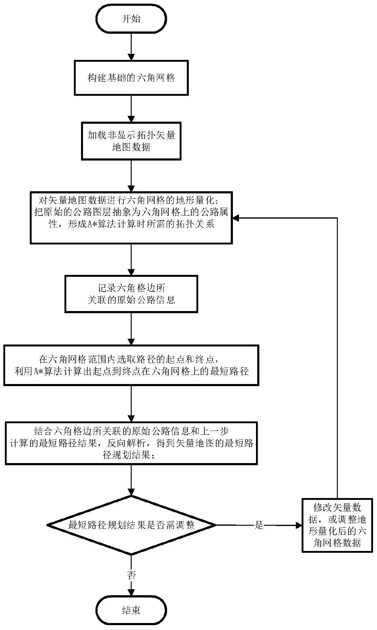
[0044] The technical solutions of the present invention will be further described below in conjunction with the accompanying drawings and embodiments.

[0045] See figure 1 , which shows a flow chart of a path planning method based on a non-display topology vector map according to the present invention, the method includes the following steps:

[0046] Step 1: Build the base hex grid:

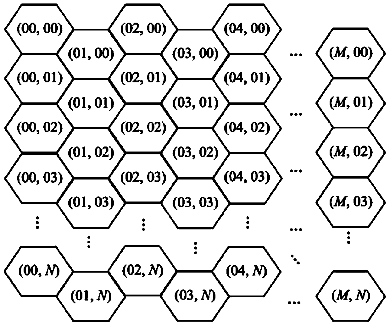
[0047] Define a hexagonal grid numbering scheme, such as figure 2 As shown, the abscissa M and the ordinate N represent the column index and the row index in the hexagonal grid respectively;

[0048] According to actual data, such as: path planning range, original vector road layer data (such as Figure 6 As shown), the speed of the vehicle under different terrain and different grades of roads, set the size of the hexagonal grid, and establish a hexagonal grid model (such as Figure 7 shown), and build a data structure, wherein the unit of the hexagonal grid is an adjacent spliced ​​hexago...


PUM


Abstract

The invention discloses a path planning method based on a non-display topology vector map. The method comprises the steps of: (1) constructing a basic hexagonal grid; (2) performing terrain quantification by using DEM data and the vector map, abstracting an original highway map layer as a road attribute on the hexagonal grid, and forming a topological relationship required during A * algorithm calculation; (3) recording original road information associated with an edge; (4) selecting a starting point and an end point of a path, and calculating the shortest path from the starting point to the end point on the hexagonal grid by using an A * algorithm; (5) combining the recorded original highway information with the calculated shortest path result to reversely analyze a shortest path planningresult of the vector map; and (6) judging whether the shortest path needs to be adjusted. When the shortest path is unreasonable due to the terrain quantification and irregular data and other reasons, related data can be manually adjusted, and recalculation is performed to obtain the shortest path. By adopting the path planning method disclosed by the invention, the shortest path planning problemwhen a user has only the non-display topology vector map is solved.

Description

technical field [0001] The present invention relates to a method for planning a route based on map data; in particular, it relates to a method for planning a route based on a non-display topological vector map. Background technique [0002] The ISO GDF4.0 model defines three topological relationships for road connectivity topology, namely Full Topology, Connectivity Topology and Non-explicit Topology. Both complete topology and connected topology establish the topological relationship between elements in the spatial data structure, and the corresponding elements are called topological elements. Topological elements are composed of basic geometric primitives such as nodes, arcs, and surfaces, which not only represent the geometric shape and position of related elements, but also express the topological information between elements. In the non-display topological relationship, the topological relationship between elements needs to be calculated or inferred by the coordinate v...

Claims


Application Information

Patent Timeline
Patent Type & Authority Applications(China)
IPC IPC(8): G01C21/34
CPCG01C21/3446
Inventor 刘雅杨荣陈超陶章志李云龙吕庆乔晓王森
Owner THE 28TH RES INST OF CHINA ELECTRONICS TECH GROUP CORP
Why Eureka
Try Eureka