Space-ground combined orbit calculation method for navigation constellation measurement and control management

A technology of orbit calculation and constellation, which is applied in the field of space-earth joint orbit calculation oriented to navigation constellation measurement and control management, can solve the problems of lack of absolute space position reference, lack of rank of normal equations, and inability to use single-satellite orbit calculation methods, etc.

Active Publication Date: 2021-03-30
CHINA XIAN SATELLITE CONTROL CENT
View PDF3 Cites 0 Cited by
  • Summary
  • Abstract
  • Description
  • Claims
  • Application Information

AI Technical Summary

Benefits of technology

This patented technology helps improve health by providing an effective treatment for certain medical conditions or diseases that are associated with these symptoms.

Problems solved by technology

This patented technology describes a new type of communication systems called GNSS that allows different types of objects like vehicles or people to communicate without being limited within their own borders. These devices use radio waves from gamma ray sources instead of sound signals to measure distances accurately over large areas at high speeds. They also have radar capabilities to help identify nearby targets while navigating around obstacles such as buildings or trees. Overall, this innovative solution simplifies the process of measuring and controlling terrestrial networks and provides more accurate measurements compared to previous methods.

Method used


Image

  • Space-ground combined orbit calculation method for navigation constellation measurement and control management
  • Space-ground combined orbit calculation method for navigation constellation measurement and control management
  • Space-ground combined orbit calculation method for navigation constellation measurement and control management

Examples


Embodiment

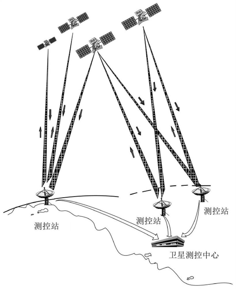
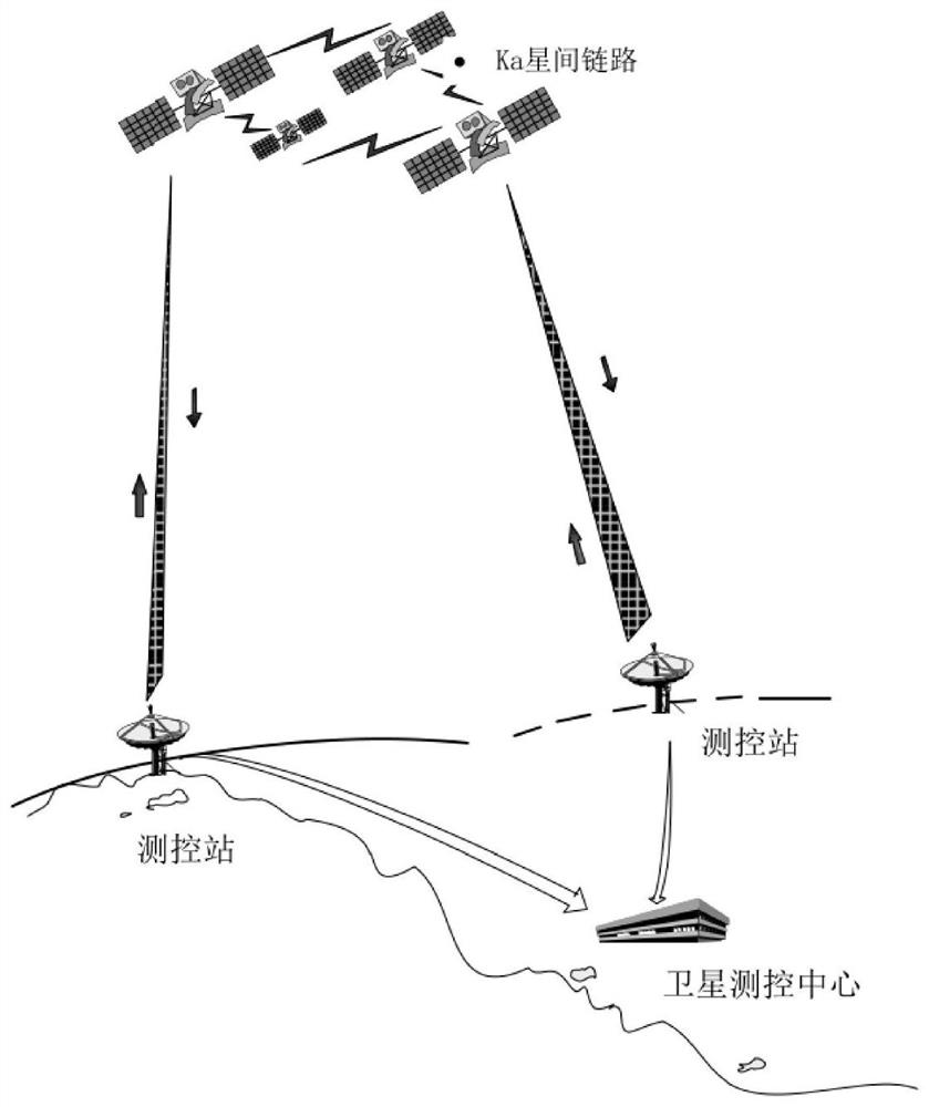
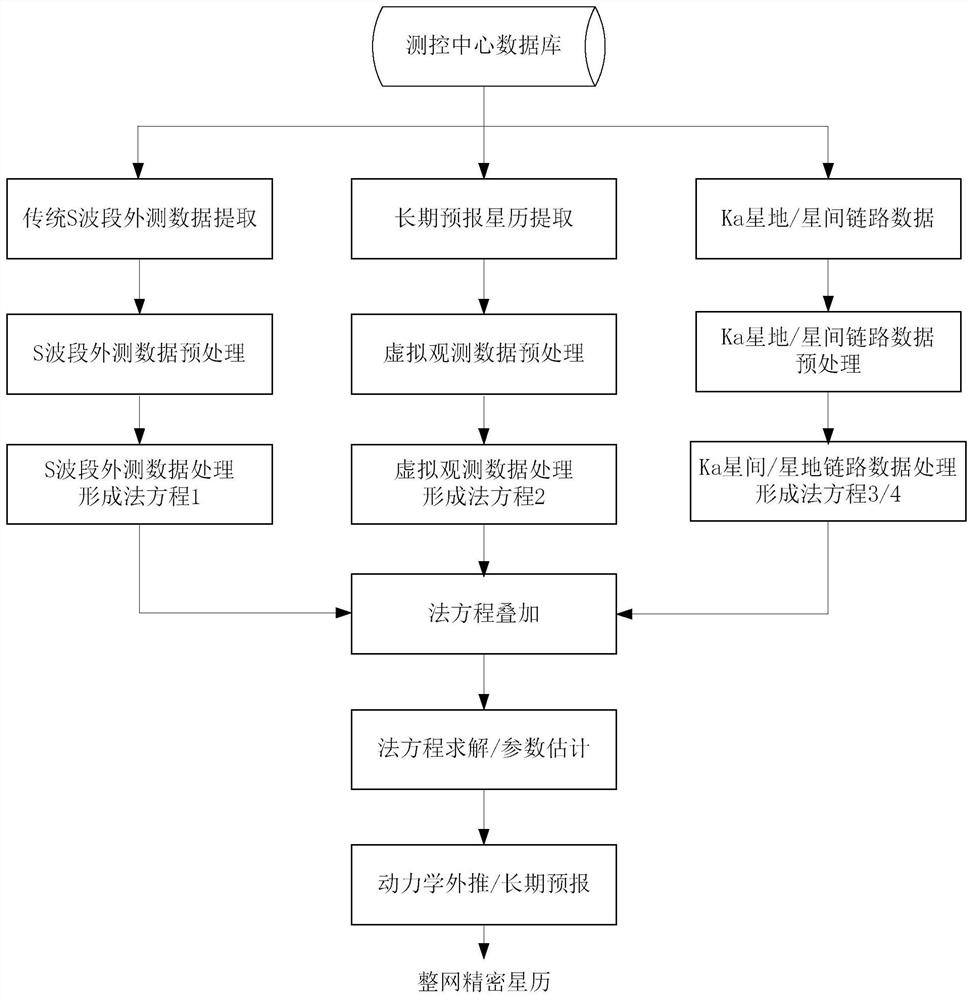
[0093] The method proposed by the invention has been applied in engineering in the measurement and control process of the Beidou satellite, and the orbit determination accuracy is significantly higher than the traditional S-band measurement and control orbit determination method, effectively utilizing the high-precision characteristics of the inter-satellite link. Using the joint orbit determination method proposed by the present invention, the data residual rms of the inter-satellite link is about 0.3m, such as Figure 5 As shown, the radial accuracy of the Beidou satellite orbit is better than 0.2 meters, and the three-dimensional position accuracy is better than 3 meters, such as Image 6 As shown, it provides an effective means for Beidou satellite to realize fine measurement and control.

[0094] Through the above method, the present invention is a space-earth joint orbit calculation method oriented to navigation constellation measurement and control management, which des...


PUM


Abstract

The invention discloses a space-ground combined orbit calculation method for navigation constellation measurement and control management. The method comprises: designing a space foundation whole network orbit calculation process for avoiding normal equation rank depletion, using a long-term forecast ephemeris as virtual observation for constraint, and combining traditional foundation S-band measurement data and a Ka inter-satellite link weighted fusion algorithm to calculate the space-ground combined orbit of the navigation constellation measurement and control management; and comprehensivelyprocessing traditional ground-based S-band tracking data and inter-satellite link bidirectional distance measurement to obtain a precise ephemeris product for supporting navigation satellite measurement and control management and inter-satellite link management.

Description


Claims


Application Information

Patent Timeline
Owner CHINA XIAN SATELLITE CONTROL CENT
Why Eureka
Try Eureka