Inverted fold three-dimensional geological modeling method based on section line and keel line control

A technology for inverting folds and modeling methods, which is applied in the field of 3D geological modeling of inverting folds, which can solve the problems of increasing the difficulty of modeling and being unusable, and achieve the effect of overcoming the confusion of spatial scattered points.

Active Publication Date: 2021-06-15
武汉地大坤迪科技有限公司
View PDF5 Cites 0 Cited by
  • Summary
  • Abstract
  • Description
  • Claims
  • Application Information

AI Technical Summary

Problems solved by technology

Inverted folds, a multi-valued geological structure formed by complex structural deformation, greatly increase the difficulty of modeling, and cannot use conventional surface modeling methods to construct its shape

Method used


Image

  • Inverted fold three-dimensional geological modeling method based on section line and keel line control
  • Inverted fold three-dimensional geological modeling method based on section line and keel line control
  • Inverted fold three-dimensional geological modeling method based on section line and keel line control

Examples


Embodiment Construction

[0032] The present invention will be described in detail below in conjunction with the accompanying drawings and embodiments, and the content of the present invention is not limited to the following embodiments.

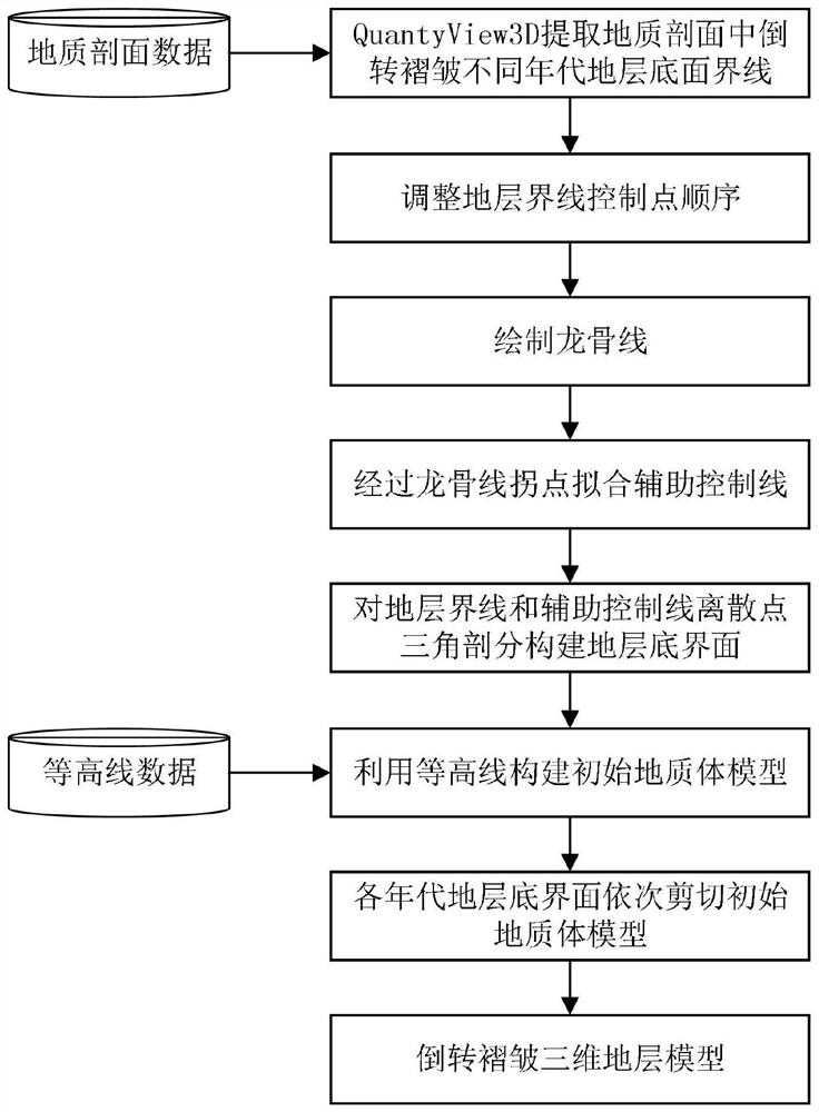
[0033] refer to figure 1 , a three-dimensional geological modeling method for inverted folds based on section lines and keel lines, which specifically includes the following steps:

[0034] Obtain the bottom boundaries of each chronostratigraphy corresponding to the inverted folds in the series of geological sections, and assign age attributes to the bottom boundaries of the strata according to the chronostratigraphy to which the bottom boundaries of the strata belong; To the six levels of Xiaofenyu, Boundary, System, System, Order, and Generation, the unit in this embodiment is order, which refers to the formation formed within a "period".

[0035] According to the natural relationship between strata or the method of isotope age, etc., it can be judged which order ...


PUM


Abstract

The invention discloses an inverted fold three-dimensional geological modeling method based on section line and keel line control. The method comprises the following steps: firstly, endowing a stratum bottom boundary with age attributes according to age stratums to which the stratum bottom boundary belongs; changing a boundary control point sequence of the stratum bottom boundary, drawing a keel line intersecting with the stratum bottom boundary, and constructing a bottom interface of the stratum in the age by utilizing triangulation; constructing an initial three-dimensional geologic body model; and finally, sequentially shearing the initial three-dimensional geologic body model by utilizing bottom interfaces of strata in all years to obtain a three-dimensional geometric structure model with fine inverted folds. According to the method, a series of scattered point sets which are orderly and uniformly distributed in space are obtained by utilizing profile stratigraphic lines and keel lines, the problems that spatial scattered points are disordered and a stratigraphic bottom interface cannot be constructed in a conventional interpolation method are solved, and meanwhile, due to the addition of the keel lines, geological cognition can be integrated into the form of a control ground interface; and the interface is more in line with actual geological significance.

Description

technical field [0001] The invention relates to a three-dimensional geological modeling method for inverted folds based on the control of section lines and keel lines, and belongs to the field of three-dimensional geological structure modeling. Background technique [0002] Manganese occupies a very important strategic position in the national economy. With the gradual reduction of surface mines, shallow mines, and easily identifiable mines, the direction of ore prospecting is gradually shifting from surface mines to deep concealed ore bodies, and the demand for mineral resource prediction is increasing day by day. 3D geological modeling technology can intuitively and accurately reconstruct the structure of geological objects based on the model, and vividly express the spatial shape and distribution of geological bodies. Therefore, establishing a fine three-dimensional geological model for manganese deposits allows geological and mining technicians to understand the geologic...

Claims


Application Information

Patent Timeline
IPC IPC(8): G06T17/05G06T17/20
CPCG06T17/05G06T17/205
Inventor 张夏林吴冲龙田宜平吴雪超张志庭翁正平李岩李俊杰江志鹏曾祥武张楠
Owner 武汉地大坤迪科技有限公司
Why Eureka
Try Eureka