Ridge line extraction method combining morphological characteristics and runoff simulation

A technology of morphological features and extraction methods, applied in character and pattern recognition, computing, computer parts and other directions, can solve problems such as poor comparability of ridge lines

Active Publication Date: 2022-05-10
SOUTHWEST PETROLEUM UNIV +1
View PDF10 Cites 0 Cited by
  • Summary
  • Abstract
  • Description
  • Claims
  • Application Information

AI Technical Summary

Problems solved by technology

[0004] The purpose of the present invention is to provide a ridgeline extraction method that combines morphological features and runoff simulation to solve the problem of poor comparability of the extracted ridgelines in the prior art due to the lack of clear threshold selection instructions, and to improve the extraction of ridgelines. Comparability, the purpose of improving the accuracy of ridgeline extraction

Method used


Image

  • Ridge line extraction method combining morphological characteristics and runoff simulation
  • Ridge line extraction method combining morphological characteristics and runoff simulation
  • Ridge line extraction method combining morphological characteristics and runoff simulation

Examples


Embodiment 1

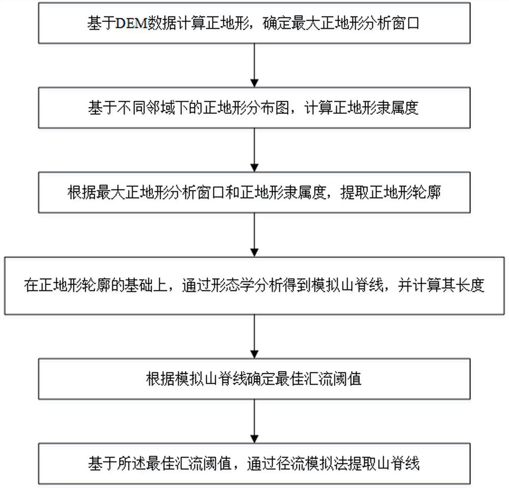
[0052] A ridgeline extraction method combining morphological features and runoff simulation, such as figure 1 shown, including:

[0053] Step S1, calculating the positive terrain based on the DEM data, and determining the maximum positive terrain analysis window;

[0054] Step S2. Based on the positive terrain distribution maps in different neighborhoods, calculate the positive terrain membership degree;

[0055] Step S3, according to the maximum positive terrain analysis window and positive terrain membership degree, extract the positive terrain contour;

[0056] Step S4, on the basis of the positive terrain profile, obtain the simulated ridge line through morphological analysis, and calculate its length;

[0057] Step S5, determining the optimal confluence threshold according to the simulated ridgeline;

[0058] Step S6 , based on the optimal confluence threshold, extract the ridgeline by runoff simulation.

[0059] Preferably, the method for determining the maximum pos...

Embodiment 2

[0073] A ridgeline extraction method combining morphological features and runoff simulation, the main process includes:

[0074] (1) Positive terrain calculation.

[0075] The positive topography is a relatively high part within a certain range, which can be measured by the macroscopic shape factor P To be districted

[0076] point. when P When >0, it is positive terrain, and its calculation formula is as follows:

[0077]

[0078] in H i,j is the elevation value of the center grid of the window, is the sum of the elevation values ​​of the valid raster in the window, n is the number of active grids in the window.

[0079] (2) Determine the maximum positive terrain analysis window.

[0080] In the process of positive terrain analysis, the size of the local neighborhood plays a crucial role in whether it is positive terrain. This embodiment is based on the multiple neighborhood analysis of DEM, and determines the regularity of the area of ​​the positive terrain wit...

Embodiment 3

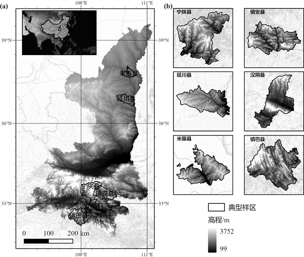
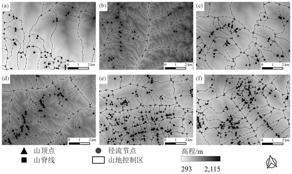
[0100] In order to verify the accuracy of the application method, this embodiment is based on the extraction method described in Example 2, as in figure 2 The six typical plots shown were tested.

[0101] figure 2The study area shown is Shaanxi Province (105°29′E~111°15′E, 31°42′N~39°35′N), which is located in the hinterland of northwest China, with a land area of ​​205,700 km2. The general feature of Shaanxi Province's topography is that it is high in the north and south and low in the middle. At the same time, the feature of terrain sloping from west to east is also obvious. Beishan and Qinling divide Shaanxi into three natural regions: the northern part is the Northern Shaanxi Plateau, which includes aeolian landforms, loess plateau (including plateaus, beams, hills, hills and gullies, etc.) landforms, and the precipitation is scarce and unevenly distributed, which is an ecologically fragile area. The frequency of drought is high and the soil erosion is serious; the ce...


PUM


Abstract

The invention discloses a ridge line extraction method combining morphological characteristics and runoff simulation, and the method comprises the steps: calculating a positive terrain based on DEM data, and determining a maximum positive terrain analysis window; calculating positive terrain membership degrees based on the positive terrain distribution diagrams in different neighborhoods; extracting a positive terrain contour according to the maximum positive terrain analysis window and the positive terrain membership degree; on the basis of the positive terrain contour, a simulated ridge line is obtained through morphological analysis, and the length of the simulated ridge line is calculated; determining an optimal confluence threshold according to the simulated ridge line; and based on the optimal confluence threshold, extracting a ridge line through a runoff simulation method. The invention aims to provide the ridge line extraction method combining morphological characteristics and runoff simulation, so as to solve the problem of poor comparability of the extracted ridge line caused by lack of clear threshold selection instructions in the prior art, and achieve the purposes of improving the comparability of the extracted ridge line and improving the extraction accuracy of the ridge line.

Description

technical field [0001] The invention relates to the field of digital terrain analysis, in particular to a ridgeline extraction method combining morphological features and runoff simulation. Background technique [0002] Ridgeline, as one of the typical topographical structure lines, is a clear and objective topographic feature object, which has an obvious guiding role for geological work. The traditional terrain structure line extraction is mainly through the contour line and topographic section extreme value judgment method, skeletonization method and runoff simulation method. Among them, the use of runoff simulation methods to extract ridgelines has been widely used in the prior art. [0003] However, in the existing process of extracting ridgelines using runoff simulation methods, there is a lack of clear threshold selection instructions, and the uncertainty of the threshold in this process makes the comparability of the extracted ridgelines poor. Contents of the inven...

Claims


Application Information

Patent Timeline
IPC IPC(8): G06V10/48
Inventor 胡金龙罗明良
Owner SOUTHWEST PETROLEUM UNIV
Why Eureka
Try Eureka