Automatically and accurately conflating road vector data, street maps, and orthoimagery

a technology of orthoimagery and vector data, applied in image analysis, scene recognition, instruments, etc., can solve the problems of laborious manual conflation techniques, inability to provide automatic conflation, and difficulty in accurately integrating different types of geospatial data

Inactive Publication Date: 2007-01-18
UNIV OF SOUTHERN CALIFORNIA
View PDF1 Cites 201 Cited by
  • Summary
  • Abstract
  • Description
  • Claims
  • Application Information

AI Technical Summary

Benefits of technology

[0010] Various conflation systems and techniques are presented herein, including vector-imagery conflation and map-imagery conflation. Vector-imagery conflation is an efficient approach that exploits knowledge from multiple data sources to identify a set of accurate control points. Vector-imagery conflation provides automatic and accurate alignment of various vector datasets and imagery. Map-imagery conflation utilizes common vector datasets as “glue” to automatically integrate street maps with imagery. This approach provides automatic, accurate, and intelligent images that combine the visual appeal and accuracy of imagery with the detailed attribution information often contained in such diverse maps. Both conflation approaches are applicable for GIS applications requiring, for example, alignment of vector data, raster maps, and imagery. If desired, the conflated data generated by such systems may be retrieved on-demand.

Problems solved by technology

However, accurately integrating different types of geospatial data remains a challenging task because diverse geospatial data have different projections and different accuracy levels, for example.
However, this approach requires human intervention to perform an initial affine transformation between datasets.
However, these products do not provide automatic conflation, so users are required to manually select control points for conflation.
In general, manual conflation techniques are labor intensive, and are subject to undesirable user errors.

Method used


Image

  • Automatically and accurately conflating road vector data, street maps, and orthoimagery
  • Automatically and accurately conflating road vector data, street maps, and orthoimagery
  • Automatically and accurately conflating road vector data, street maps, and orthoimagery

Examples


Embodiment Construction

[0139] In the following detailed description, reference is made to the accompanying drawing figures which form a part hereof, and which show by way of illustration specific embodiments of the invention. It is to be understood by those of ordinary skill in this technological field that other embodiments may be utilized, and structural, electrical, as well as procedural changes may be made without departing from the scope of the present invention.
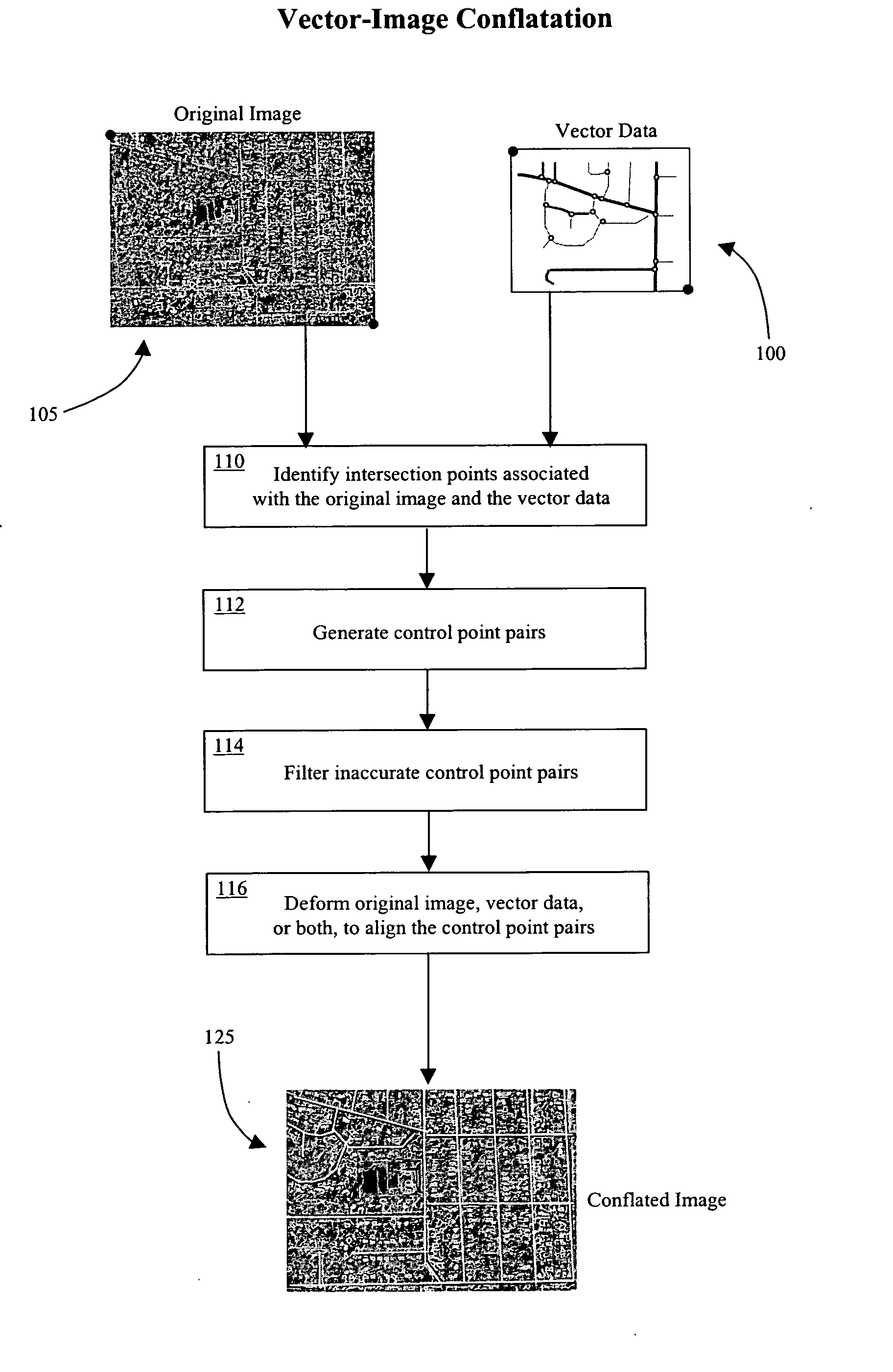
1.0 Overview

[0140] With the rapid improvement of geospatial data collection techniques, the growth of the Internet, and the implementation of Open GIS, a large amount of geospatial data is now readily available. Examples of well-known vector datasets include U.S. Census TIGER / Line files (covering most roads within the United States), NAVSTREETS from NAVTEQ, and the GDT data from Geographic Data Technology. National Map, Geography Network from Environmental Systems Research Institute (ESRI), MapQuest, Yahoo Map service, Google Map / Imagery s...


PUM


Abstract

Automatic conflation systems and techniques which provide vector-imagery conflation and map-imagery conflation. Vector-imagery conflation is an efficient approach that exploits knowledge from multiple data sources to identify a set of accurate control points. Vector-imagery conflation provides automatic and accurate alignment of various vector datasets and imagery, and is appropriate for GIS applications, for example, requiring alignment of vector data and imagery over large geographical regions. Map-imagery conflation utilizes common vector datasets as “glue” to automatically integrate street maps with imagery. This approach provides automatic, accurate, and intelligent images that combine the visual appeal and accuracy of imagery with the detailed attribution information often contained in such diverse maps. Both conflation approaches are applicable for GIS applications requiring, for example, alignment of vector data, raster maps, and imagery. If desired, the conflated data generated by such systems may be retrieved on-demand.

Description

CROSS-REFERENCE TO RELATED APPLICATIONS [0001] This application claims benefit of priority from U.S. provisional patent application Ser. No. 60 / 586,623, filed 9 Jul. 2004.STATEMENT REGARDING FEDERALLY SPONSORED RESEARCH OR DEVELOPMENT [0002] Research leading to certain embodiments of the present invention has been funded in part by National Science Foundation (NSF) grant numbers EEC-9529152 (IMSC ERC), IIS-0238560 (PECASE), and IIS-0324955 (ITR), in part by the U.S. Air Force Office of Scientific Research under grant numbers F49620-01-1-0053 and FA9550-04-1-0105, in part by a grant from the U.S. Geological Survey (USGS) under grant number 03CRSA0631. Accordingly, the United States Government may have certain rights in the present invention.BACKGROUND OF THE INVENTION [0003] 1. Field of the Invention [0004] The present invention relates generally to vector data, map, and imagery systems, and in particular to a system for automatically conflating road vector data, street maps, and ort...

Claims


Application Information

Patent Timeline
Patent Type & Authority Applications(United States)
IPC IPC(8): G06K9/32G06K9/46G06V20/13
CPCG06K9/0063G06T7/0028G06T3/0075G06T7/33G06V20/13
Inventor CHEN, CHING-CHIENKNOBLOCK, CRAIG A.SHAHABI, CYRUSCHIANG, YAO-YI
Owner UNIV OF SOUTHERN CALIFORNIA
Why Eureka
Try Eureka