Method and apparatus for accessing multi-dimensional mapping and information

a multi-dimensional mapping and information technology, applied in the field of visual data viewing, can solve the problems of limited view of a location, user's inability to see what the location looks like, and the inability to provide a picture or movie imag

Inactive Publication Date: 2007-11-29
TRUE VOYAGER
View PDF11 Cites 129 Cited by
  • Summary
  • Abstract
  • Description
  • Claims
  • Application Information

AI Technical Summary

Problems solved by technology

However, these map applications have shortcomings in that they do not provide a picture or movie image of the indicated location.
As such, the user is not able to see what the location looks like without visiting the location in person.
However, typical images present only a limited view of a location in that the image do

Method used


Image

  • Method and apparatus for accessing multi-dimensional mapping and information
  • Method and apparatus for accessing multi-dimensional mapping and information
  • Method and apparatus for accessing multi-dimensional mapping and information

Examples


Embodiment Construction

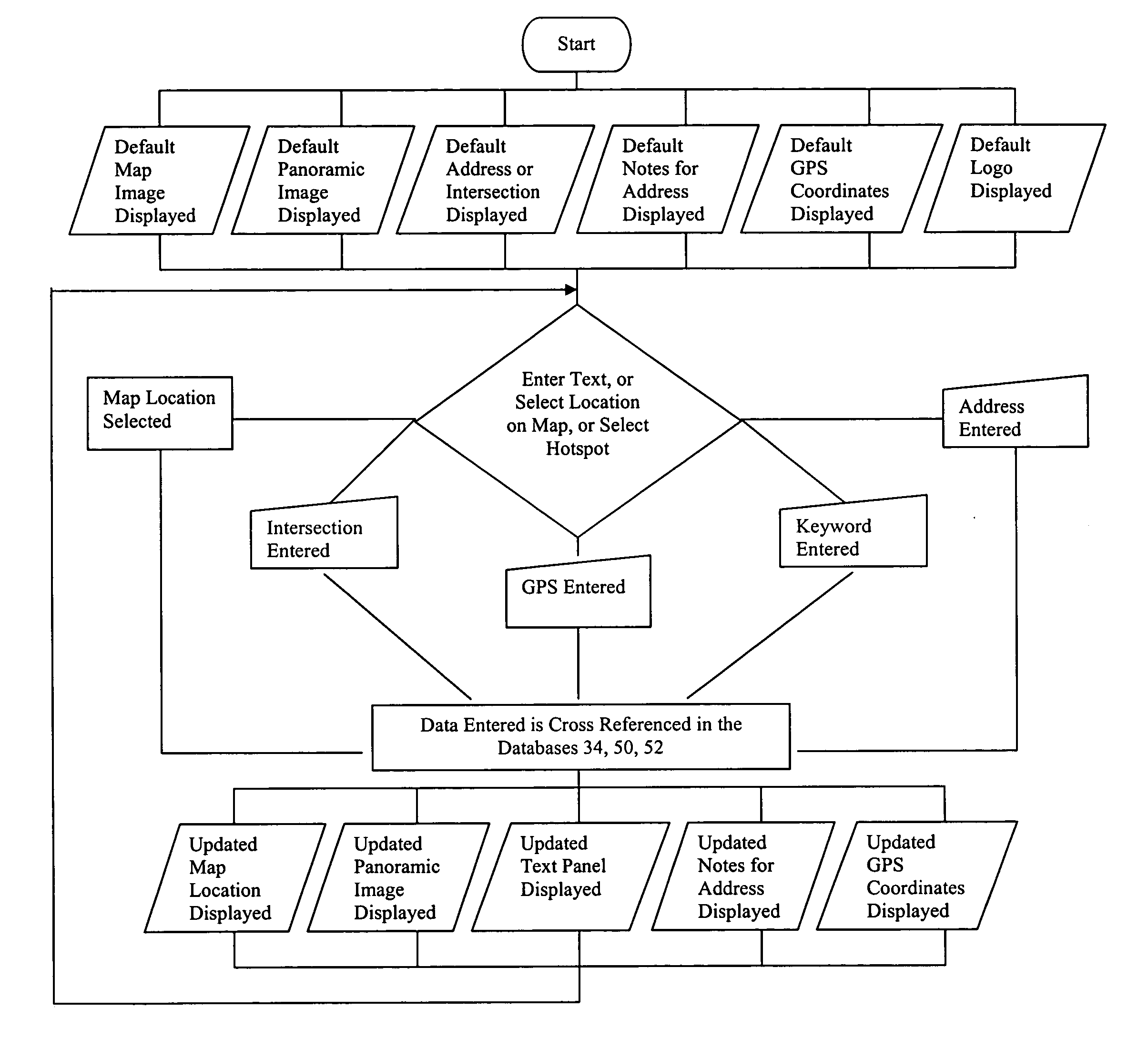
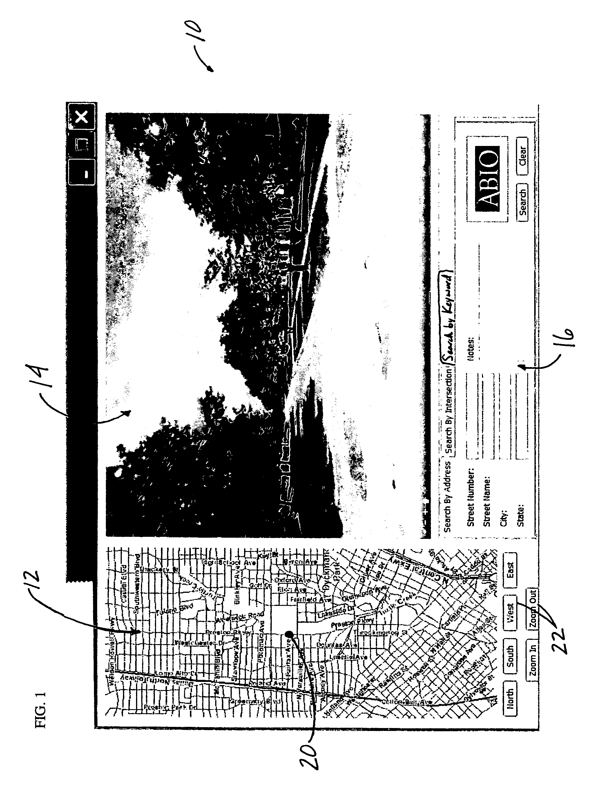
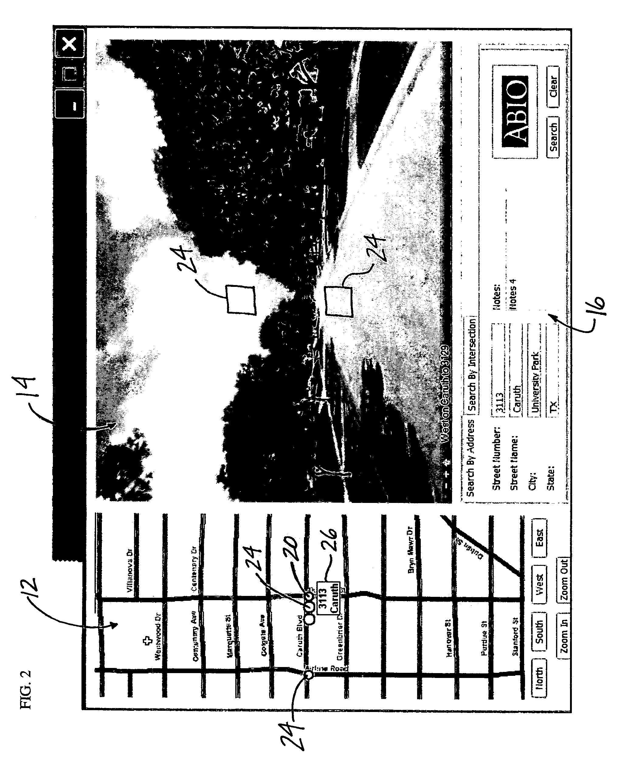
[0029] The product consists of numerous photographic or similar images in a database format. The images are panoramas of various locations of interest. The panoramas are viewed with Apple's QuickTime™ VR or similar method. The images have hot spot locations embedded within them that permit the user to navigate to other points in the image database that are adjacent to the image being viewed. The images may have other data associated with them such as street address, zip code, GPS coordinate, Mapsco™ reference or similar, top-down (2-D) map location, property lot size, pertinent historical information, or other. The product is intended to replace or enhance 2-D maps with actual imagery in place of, or in conjunction with, overhead and / or panoramic views of locations. The product can be scaled, for example, from an individual home location to a city area. Preferably, it is intended that images be taken at least every 50 feet within a particular location of interest, although the inven...


PUM


Abstract

A method and apparatus for providing an interactive mapping and panoramic imaging application for utilization by a computer user is provided. A plurality of panoramic images are stored on a panoramic database, each panoramic image corresponding to a geographical location. A panoramic image is displayed on a screen and is navigable in response to input by the user. The panoramic image has embedded hotspots corresponding to selected panoramic images of geographically adjacent locations. Also displayed on the screen, simultaneously with the panoramic image, is a map image corresponding with the panoramic image. The map image is stored on a map database, and the map is navigable in response to input by the user. The map has embedded hotspots corresponding to the plurality of panoramic images. Also displayed on the screen, simultaneously with the panoramic image and the map image, is a text panel displaying textual information corresponding to the displayed panoramic image. The text panel is capable of receiving textual input from the user for activating a search of a text database having a plurality of text data corresponding to the plurality of panoramic images. The displayed panoramic image, the displayed map image and the displayed textual information are updated in response to the user activating a hotspot, such that the displayed panoramic image, the displayed map image and the displayed textual information correspond to one another.

Description

CROSS-REFERENCE TO RELATED APPLICATIONS [0001] This application claims the benefit of U.S. Provisional Application No. 60 / 580,059 filed Jun. 16, 2004.STATEMENT REGARDING FEDERALLY SPONSORED RESEARCH OR DEVELOPMENT [0002] Not applicable REFERENCE TO MICROFICHE APPENDIX [0003] Not applicable FIELD OF INVENTION [0004] This invention relates generally to viewing map and visual data, and more specifically to method and apparatus for simultaneously viewing navigable panoramic images and corresponding navigable map images and information. BACKGROUND OF THE INVENTION [0005] Using overhead, 2-D map images or bird's-eye-view map images in computer based applications has become commonplace. Typically these maps are navigable by the user and can be panned in selected directions by use of a mouse, keyboard or other input device. Usually these maps can be selectively zoomed in or out to show a larger or smaller geographical area. Often, as the image is zoomed in, more detailed information will ap...

Claims


Application Information

Patent Timeline
IPC IPC(8): H04N7/00
CPCG06F3/04815G06F16/9537
Inventor MENDOZA, FELIPELOVING, WARD HARNISH
Owner TRUE VOYAGER
Why Eureka
Try Eureka