Attribute value management system and methods

a value management system and attribute technology, applied in the field of attribute value management system and methods, can solve the problems of field workers, untrained, gis, etc., and achieve the effect of reducing the difficulty of field workers, collecting needed data, and reducing the number of users

Inactive Publication Date: 2012-03-15
ADAPX INC
View PDF6 Cites 22 Cited by
  • Summary
  • Abstract
  • Description
  • Claims
  • Application Information

AI Technical Summary

Problems solved by technology

Unfortunately, the complexity of GIS software and end-user computer equipment has made...

Method used


Image

  • Attribute value management system and methods
  • Attribute value management system and methods
  • Attribute value management system and methods

Examples


Embodiment Construction

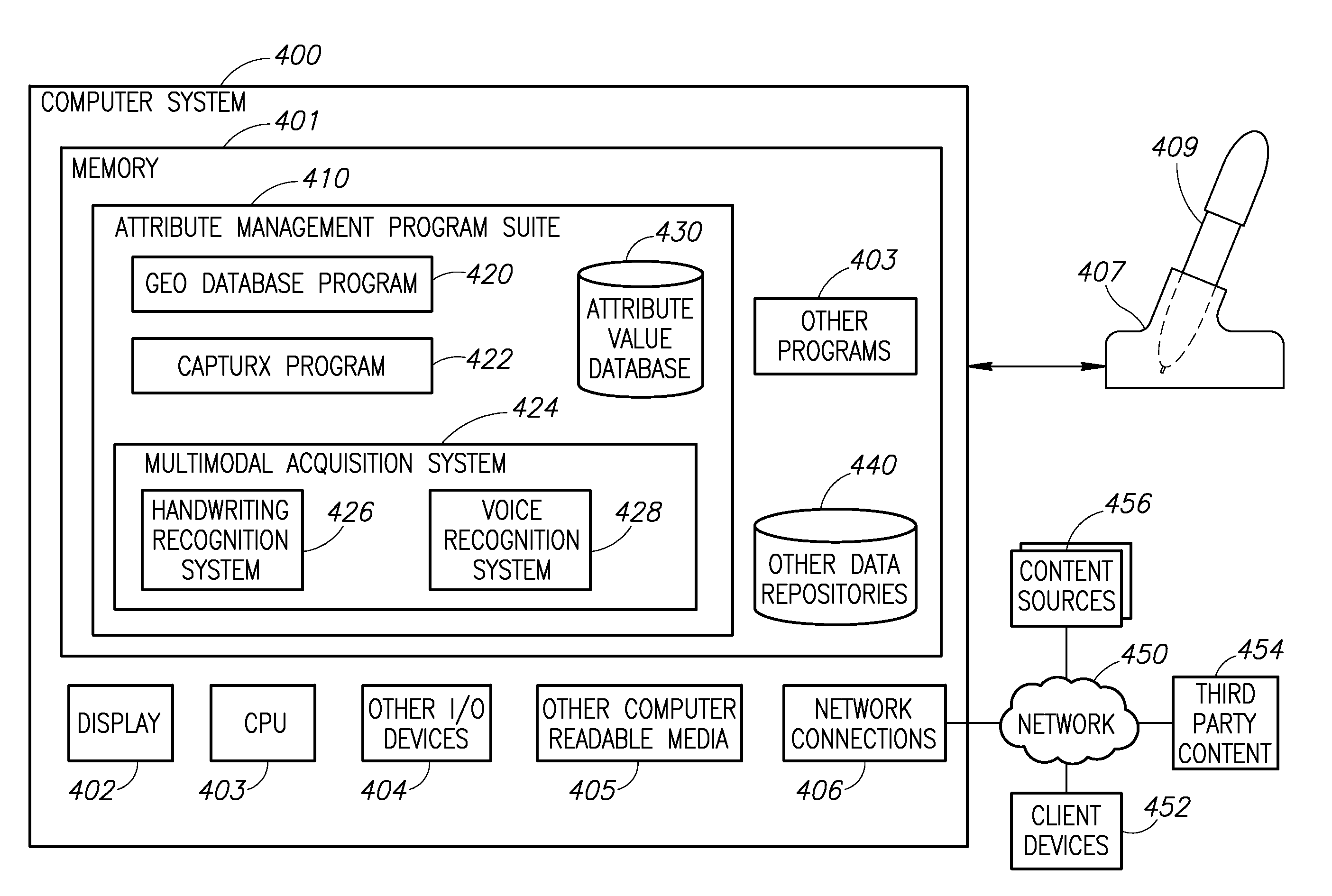
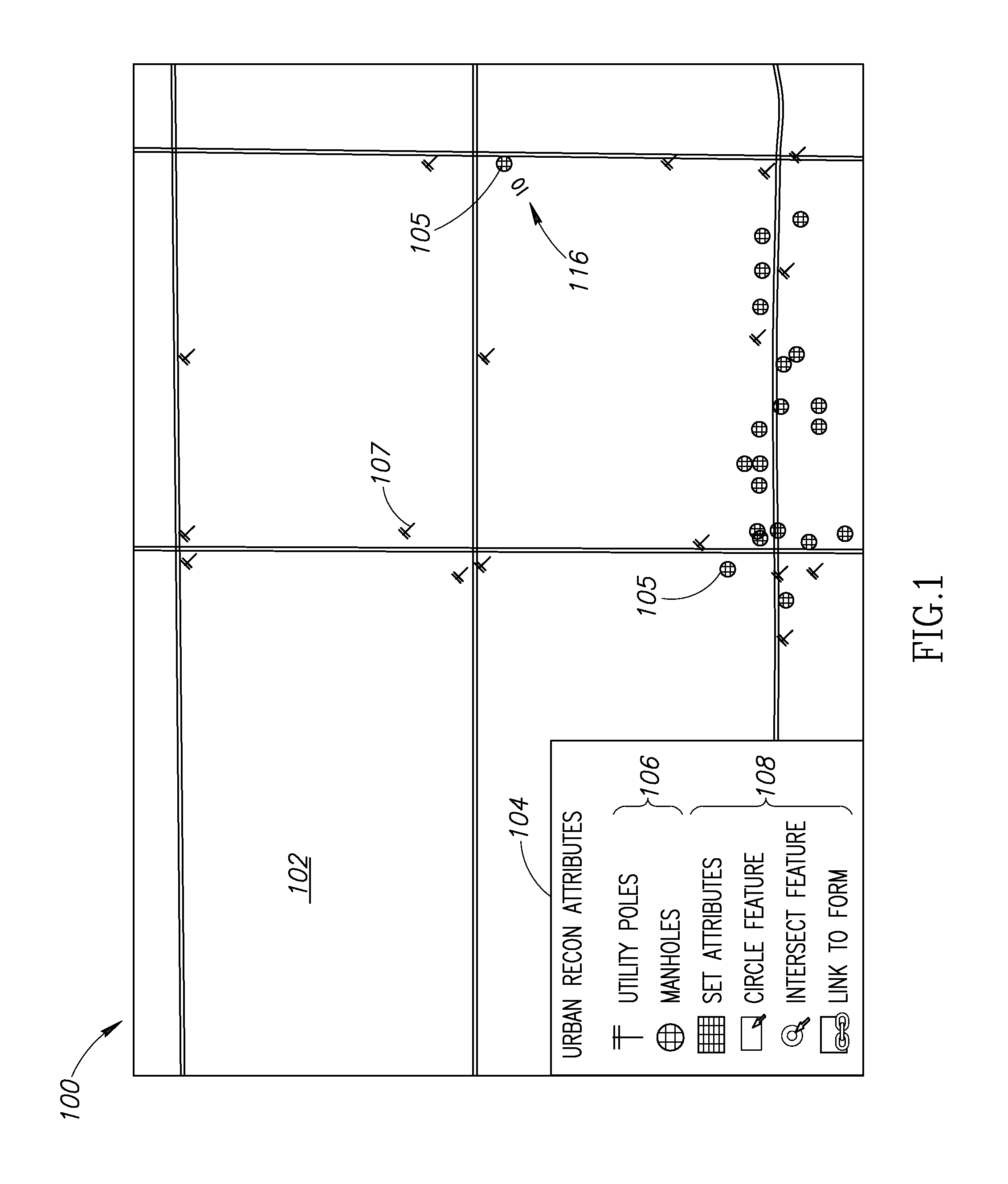
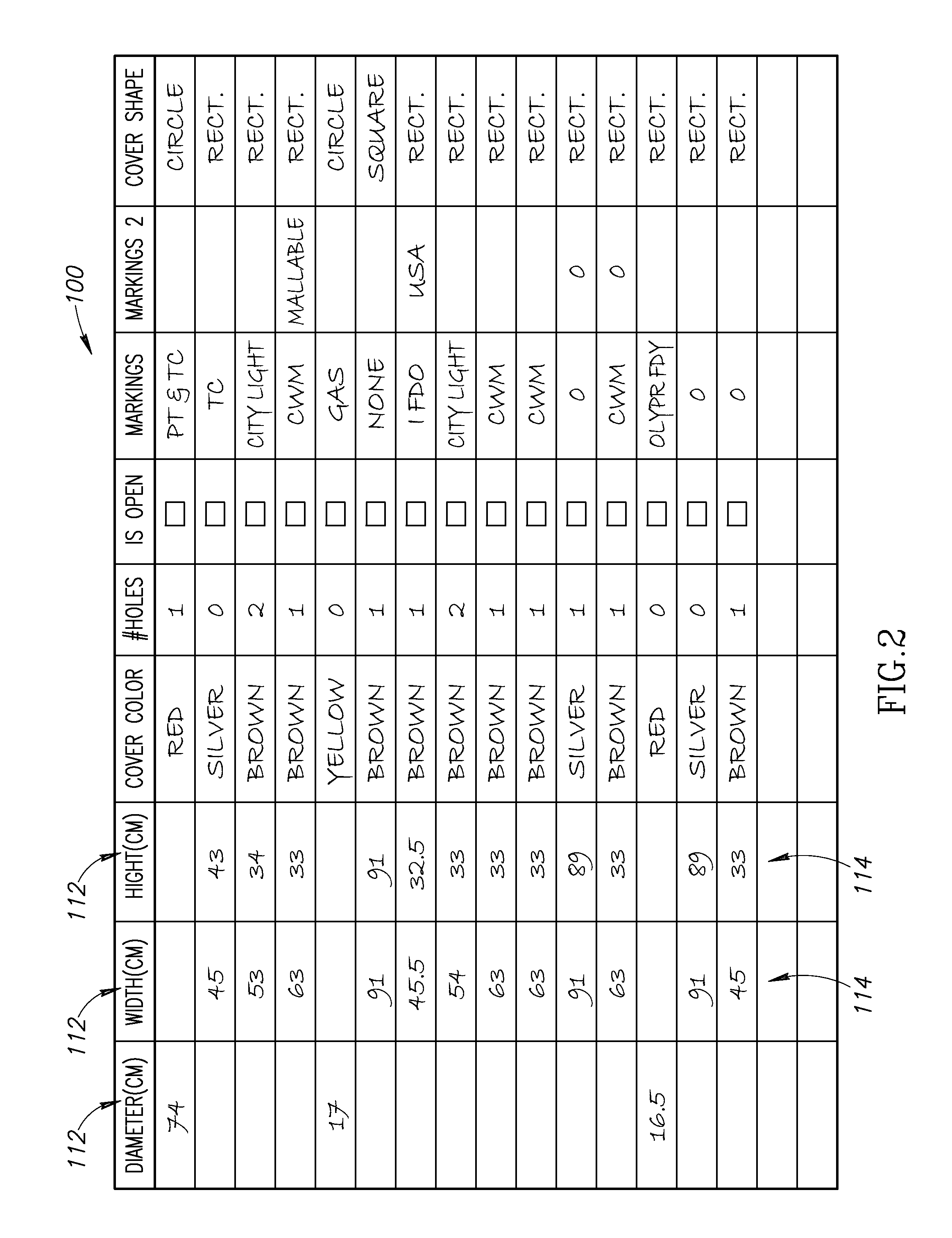
[0013]The need for collecting data via field workers untrained in the intricacies of GIS involves the use of digital pen and paper technology; one or more software applications that allows an end user to develop their own forms, maps, etc. by integrating digital pen and paper technology with other software applications; one or more methods for attribute creation, collection, revision, and fusion; and one or more methods for attribute validation (e.g., error checking). This enables the use of existing paper-based work practices, which minimizes training, while providing a digital output that can lead to substantial productivity gains.

[0014]Digital pen and paper technology provides a dot pattern that is printed on a paper document and a digital pen that senses that pattern. Unlike relative-positioning digital pens, these digital pens read not only an absolute position on a page; the pens know precisely what page it is. The pen records the coordinates of the pen on the page, as well as...


PUM


Abstract

In many environments such as municipal, military and construction the use of digital pen and paper systems permits end users to create or modify features on digital document, attributes associated with those features, or attribute values associated with those features. The attribute value management system includes a digital pen, at least one digital document, one or more computing devices, and a number of software programs for creating data relationships between the digital documents (e.g., features on maps and their underlying attribute values), interpreting voice or handwritten data, validating the interpreted data, and uploading the validated data to a geo-database. The attribute value management system functions to create, update or otherwise change the attribute values associated with the features by a temporal association method; a linked identification method; or a direct handwriting method.

Description

PRIORITY CLAIM[0001]This application claims priority to and the benefit of U.S. Provisional Application No. 61 / 371,991 entitled ATTRIBUTE COLLECTION ON PAPER MAPS filed Aug. 9, 2010, and claims priority to and the benefit of U.S. Provisional Application No. 61 / 427,971 entitled ATTRIBUTE COLLECTION ON PAPER MAPS filed on Dec. 29, 2010, both of which are incorporated by reference in their entireties.BACKGROUND OF THE INVENTION[0002]A geographical information system (“GIS”) is an information system that provides the ability to create, save, interact with, analyze, and display geospatial data. In contrast, a map display system merely has the ability to present geo-registered maps / imagery. For example, TerraGo's GeoPDF offers the ability to display maps as PDFs, and to record the geo-coordinates of a cursor, enabling “red line” markups, positioning of geo-registered icons as “stamps”, displaying a GPS trail, etc. The GIS is database driven—the visualization involves the rendering of prop...

Claims


Application Information

Patent Timeline
IPC IPC(8): G06F17/00
CPCG06F3/03545G06F3/04817G06F17/246G06F3/033G06F17/2235G06F3/0487G06F40/134G06F40/18
Inventor ROBIN, MICHAELCOHEN, PHILIP R.TRAPP PETTY, MELISSA
Owner ADAPX INC
Why Eureka
Try Eureka