Remote sensing of vehicle occupancy

a vehicle occupancy and remote sensing technology, applied in the field of remote sensing of vehicle occupancy, can solve the problem that camera-based systems are not able to easily determine the number of passengers in a vehicle, and achieve the effect of reducing or eliminating manual occupancy verification

Inactive Publication Date: 2014-09-18
HOVTAG
View PDF4 Cites 63 Cited by
  • Summary
  • Abstract
  • Description
  • Claims
  • Application Information

AI Technical Summary

Benefits of technology

[0007]The problems presented by existing systems and methods for managing toll-based roadways are solved by the systems and methods of the illustrative embodiments described herein. In one embodiment, one or more sensors are interfaced to a controller which in turn interfaces to a transponder in order to provide occupancy status of a vehicle. The one or more sensors determine the occupancy status of one or more of the seats in the vehicle, and report this to the controller. The controller determines an overall occupancy for the vehicle, and provides this information to the transponder. The transponder then communicates this information to a traffic monitoring or toll collection infrastructure, such as to a toll tag reading tower using Radio Frequency Identification (RFID) wireless communication. The collected information may then be used to reduce or eliminate manual occupancy verification by police, and to enable incentive-based toll policy.

Problems solved by technology

Unlike vehicle-identification systems that track owner information based on a vehicle's license plate, camera-based systems are not able to easily determine the number of passengers in a vehicle due to multiple factors including the inability to view some areas within the vehicle.

Method used


Image

  • Remote sensing of vehicle occupancy
  • Remote sensing of vehicle occupancy
  • Remote sensing of vehicle occupancy

Examples


example 1

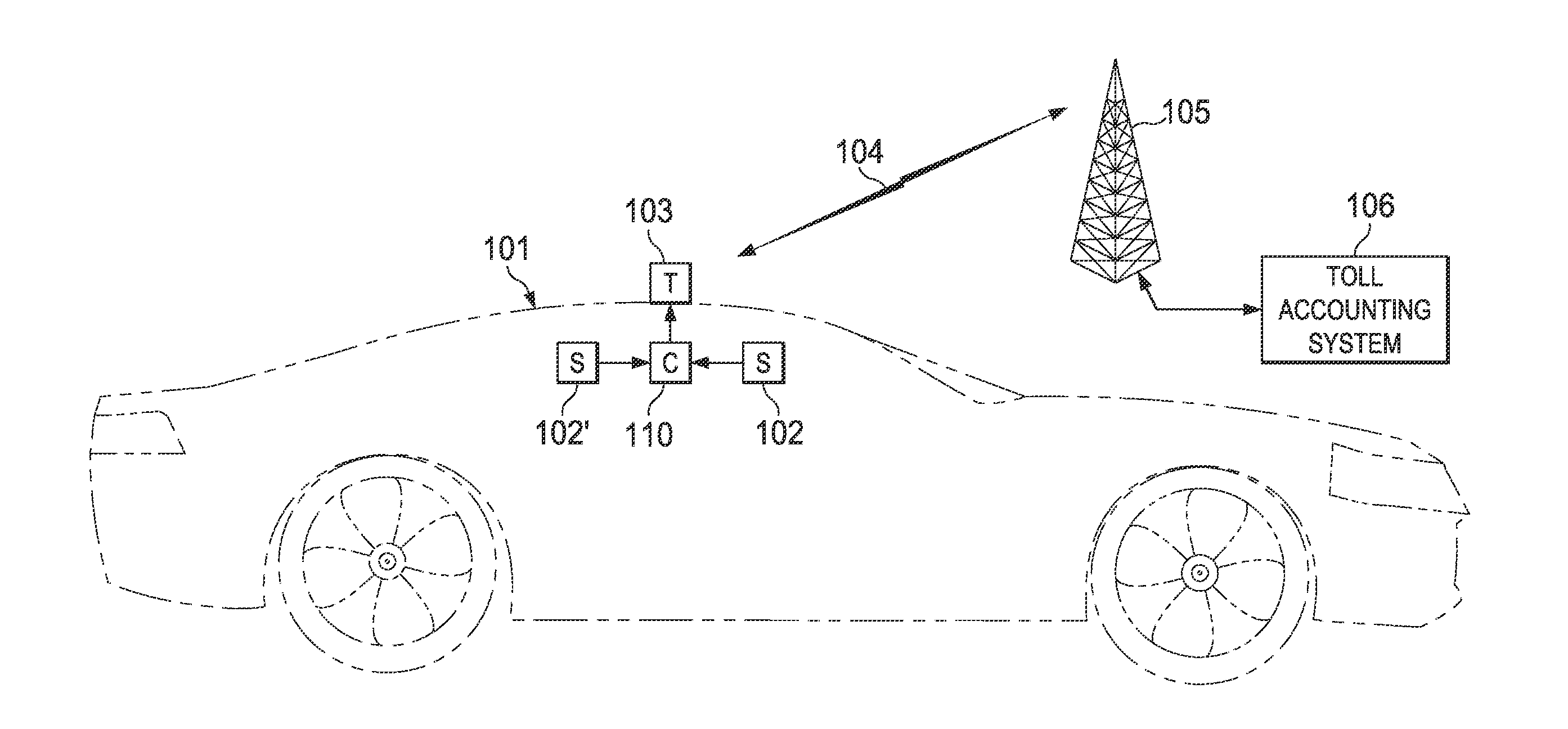
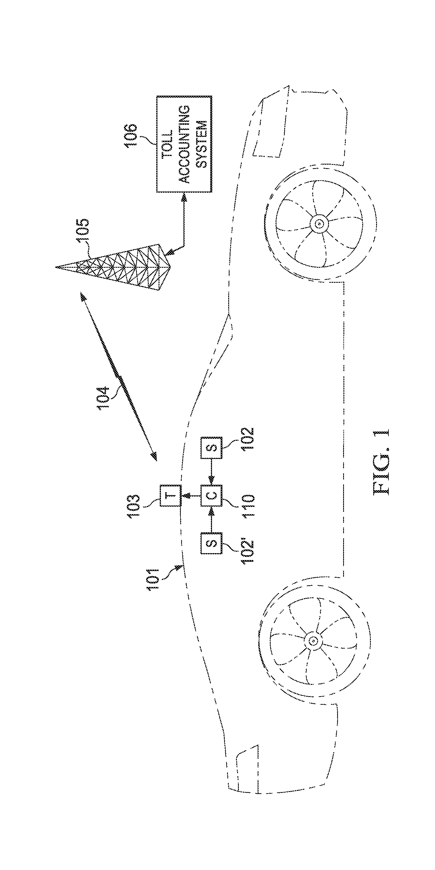
[0033]A system for managing a toll-based roadway, the system comprising:[0034]one or more receiving units positioned above or proximate the roadway; and[0035]a sensing unit positioned within a vehicle traveling on the roadway, the sensing unit configured to sense occupancy data based on the number of passengers within the vehicle;[0036]wherein the occupancy data is communicated to the one or more receiving units.

example 2

[0037]The system of example 1, wherein the sensing unit includes one or more infrared sensors for detecting heat or motion within the vehicle.

example 3

[0038]A method for managing a toll-based roadway, the method comprising:[0039]determining the number of passengers within a vehicle traveling on the roadway, said step of determining being performed from within the vehicle;[0040]communicating data related to said number of passengers to a database; and[0041]charging a toll based on the number of passengers within the vehicle.


PUM


Abstract

A system for managing a toll-based roadway includes one or more receiving units positioned above or proximate the roadway and a sensing unit positioned within a vehicle traveling on the roadway. The sensing unit is configured to sense occupancy data based on the number of passengers within the vehicle. The occupancy data is communicated to the one or more receiving units.

Description

CROSS-REFERENCE TO RELATED APPLICATIONS[0001]This application claims the benefit of and priority to U.S. Provisional Patent Application Ser. No. 61 / 794,377 filed on Mar. 15, 2013, entitled REMOTE SENSING OF VEHICLE OCCUPANCY, which is hereby incorporated by reference.BACKGROUND[0002]1. Field[0003]The disclosure generally relates to technologies for determining occupancy of a vehicle for compliance with traffic regulations such as high occupancy vehicle (HOV) lanes, managed lanes, and occupancy-based toll roads.[0004]2. Description of Related Art[0005]Many urban jurisdictions have built or implemented a variety of methods to reduce vehicle traffic, congestion, and to encourage higher occupancy of vehicles, such as installation and control of high occupancy vehicle (HOV) lanes, toll roads, and car pool tax credits.[0006]While cameras recently have been implemented to assess tolls to vehicles on toll roads by automatically recognizing a license plate in a photograph of a vehicle as it ...

Claims


Application Information

Patent Timeline
Patent Type & Authority Applications(United States)
IPC IPC(8): G07B15/06
CPCG07B15/063G06Q2240/00
Inventor NATINSKY, RON
Owner HOVTAG
Why Eureka
Try Eureka