Snow disaster remote sensing monitoring simulation evaluation method based on disaster reduction small satellite

A technology for remote sensing monitoring and snow disasters, which is applied in the field of satellite remote sensing and can solve the problems of insufficient monitoring of snow disasters in satellite remote sensing data.

Inactive Publication Date: 2010-08-11
MIN OF CIVIL AFFAIRS NAT DISASTER REDUCTION CENT
View PDF0 Cites 40 Cited by
  • Summary
  • Abstract
  • Description
  • Claims
  • Application Information

AI Technical Summary

Benefits of technology

This patented technology allows for better understanding about snow disorders through detailed analysis of smaller spacecraft (SS) images obtained during winter weather or other conditions that may affect them). It also includes simulations with realistic snow environments where environmental factors like temperature are taken into account when analyzed. By comparing these simulation results against actual measurements made over time, it becomes possible to make informed decisions based upon impact scenarios such as melting ice floes or drought caused by heavy rain. Overall, this system provides technical benefits including improved situational awareness capabilities, enhanced ability to monitor large fires without being affected by adverse atmospheric events, efficient management of Snow Dismancy Hazards, and more accurate risk evaluation than current methods.

Problems solved by technology

The technical problem addressed by this patented method relates to simulating the effects of snow debris on smaller geostationary systems like Small Satellite Radio or Optical Star Communications (Satcom) due to their high reflectivity towards solar light during winter months with temperatures below freezing at nightfall. This can lead to incorrect results when analyzed through simulations over long periods of time.

Method used


Image

  • Snow disaster remote sensing monitoring simulation evaluation method based on disaster reduction small satellite
  • Snow disaster remote sensing monitoring simulation evaluation method based on disaster reduction small satellite
  • Snow disaster remote sensing monitoring simulation evaluation method based on disaster reduction small satellite

Examples


Embodiment Construction

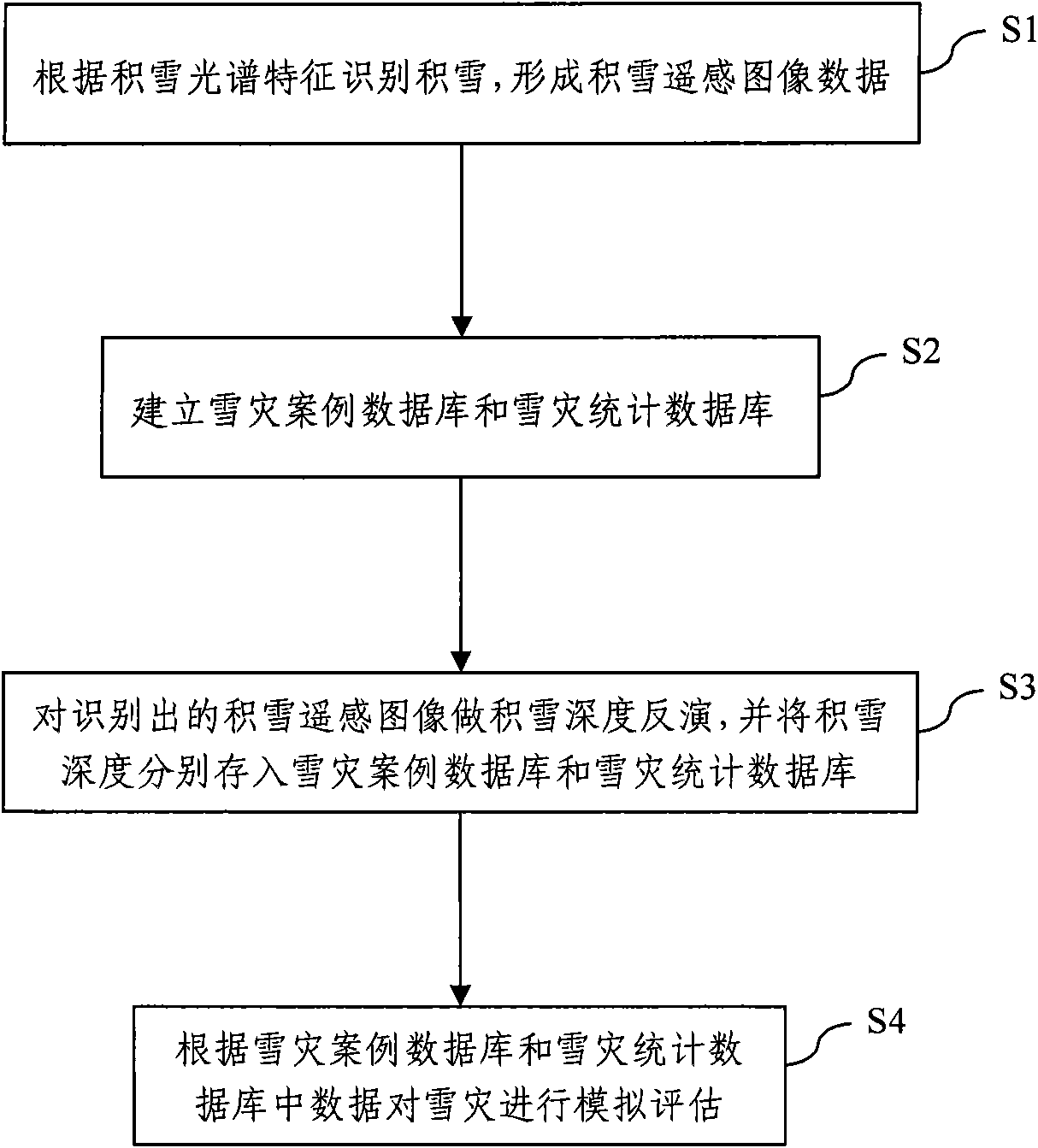
[0058] A snow disaster remote sensing monitoring simulation evaluation method based on a small disaster reduction satellite proposed by the present invention is described as follows in conjunction with the accompanying drawings and embodiments.

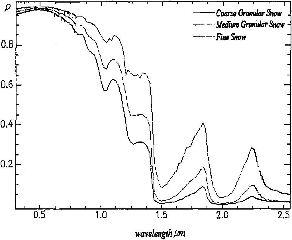
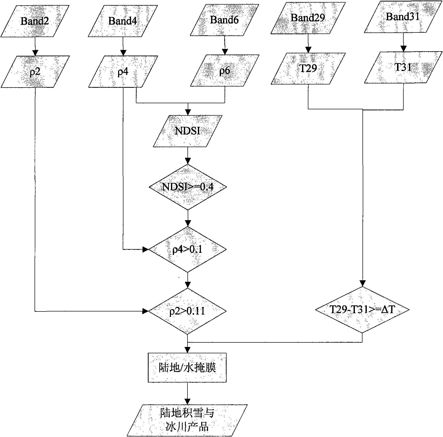
[0059] Such as figure 1 As shown, in step S1, the snow is identified according to the snow spectral characteristics, and the spectral curve of a typical snow is as follows figure 2 shown. After analysis, the snow shows high reflectivity in the visible light band (0.38μm-0.72μm) and near-infrared band (0.72μm-1.30μm), but in the near-infrared band (1.30μm-3.00μm), especially The reflectivity near the 1.55μm and 2.10μm bands is very low due to the absorption of solar radiation by snow. At the same time, in view of the fact that snow cover extraction is mainly to distinguish information such as clouds and surface objects, it is found through research that the spectra of snow, clouds, and surface objects have the following characteristic...


PUM


Abstract

The invention discloses a snow disaster remote sensing monitoring simulation evaluation method based on a disaster reduction small satellite, comprising the following steps: recognize accumulated snow according to the spectral characteristic of the accumulated snow and form accumulated snow remote sensing images data; create a snow disaster case database and a snow disaster statistical database, the snow disaster case database comprises a disaster time, a location hit by the disaster, an accumulated snow day number, a normalized difference vegetation index NDVI, a population number hit by the disaster and a accumulated snow area, the snow disaster statistical database comprises a total precipitation, a highest air temperature, a lowest air temperature, a average daily temperature, a wind speed and a surface temperature; carry out an accumulated snow depth inversion to a recognized accumulated snow, and respectively store the accumulated snow depth into the snow disaster case database and the snow disaster statistical database; carry out simulation evaluation to a snow disaster according to the data in the snow disaster case database and the snow disaster statistical database. A new and high applicability remote sensing data source is provided for snow disaster monitoring in the invention, and the snow disaster remote sensing monitoring simulation evaluation method has a great importance of disaster reduction and disaster relief works for China snow disaster.

Description


Claims


Application Information

Patent Timeline
Owner MIN OF CIVIL AFFAIRS NAT DISASTER REDUCTION CENT
Why Eureka
Try Eureka