Method for establishing digital elevation model applied to submarine topography
A technology of digital elevation model and establishment method, which is applied in the spatial field of geographic information system, and can solve the problems of inapplicability of natural neighbor interpolation and complicated realization process of constrained Voronoi diagram.
Inactive Publication Date: 2012-12-19
HARBIN ENG UNIV
View PDF2 Cites 31 Cited by
- Summary
- Abstract
- Description
- Claims
- Application Information
AI Technical Summary
Problems solved by technology
[0007] In addition to water depth points, seabed topography data also has constraints such as coastlines and islands. These constraints need to be maintained during the interpolation calculation process. However, the conventional Voronoi diagram is defined on a convex area. For areas with non-convex boundary conditions, natural neighbor interpolation Not applicable
J.Yvonnet and others proposed the constrained natural element method (C-NEM, see reference [3]: Yvonnet
Method used
View moreImage
Smart ImageViewing Examples
Examples
 PUM
 Abstract
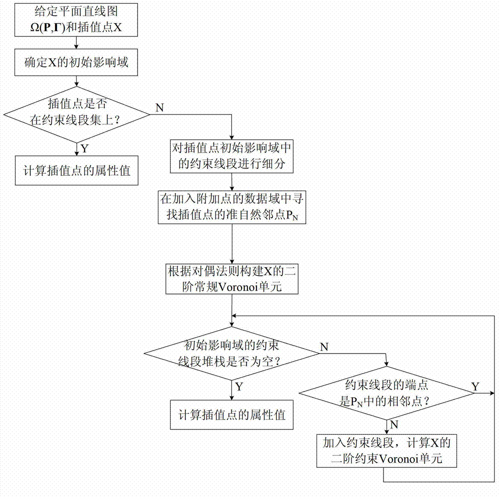
The invention discloses a method for establishing a digital elevation model applied to submarine topography. An interpolation method is adopted to blend an idea of conforming Delaunay triangulation into natural neighbor interpolation, and a new idea including interpolation of non-convex essence boundary conditions is provided. The method mainly comprises five contents as follows: establishing a triangulation network which accords with Delaunay triangulation characteristics after characteristic constraint is embedded; finding a standard natural neighbor point of an interpolation point; establishing a second order normal Voronoi unit; establishing a second order constraint Voronoi unit through the second order normal Voronoi unit; and calculating attribute values of the interpolation point. According to the method provided by the invention, a smooth interpolation function approaches to a terrain function; and the method has the advantages of being fixed in a calculation region and high in smoothness, meeting non-convex boundary conditions and being easy to implement and the like.
Description
technical field [0001] The invention belongs to the technical field of geographic information systems, and relates to the fitting of seabed topography, in particular to a method for establishing a digital elevation model applied to seabed topography. Background technique [0002] The digital elevation model is a spatial data model that describes the morphological characteristics of the surface undulation. It is a matrix composed of the elevation values of regular grid points on the ground, forming a grid structure data set. The key link in the establishment of the digital elevation model is the calculation of the elevation on the grid point, which belongs to the interpolation problem in numerical analysis in mathematics. Any interpolation method is based on the continuity of the original terrain fluctuations, that is, the correlation between adjacent data points to solve the elevation of the point to be determined. [0003] Interpolation methods based on terrain can be di...
Claims
Login to View More Application Information
Patent Timeline
 IPC IPC(8): G06T17/05
Inventor 沈志峰田峰敏赵玉新
Owner HARBIN ENG UNIV
Features
- R&D
- Intellectual Property
- Life Sciences
- Materials
- Tech Scout
- Unparalleled Data Quality
- Higher Quality Content
- 60% Fewer Hallucinations
Learn More Browse by: Latest US Patents, China's latest patents, Technical Efficacy Thesaurus, Application Domain, Technology Topic, Popular Technical Reports.
© 2025 PatSnap. All rights reserved.Legal|Privacy policy|Modern Slavery Act Transparency Statement|Sitemap|About US| Contact US: help@patsnap.com


