Rendering method and system of geographic information system

A geographic information system and map technology, applied in the field of geographic information system rendering methods and systems, can solve problems such as low efficiency and long time consumption, and achieve the effects of improving drawing efficiency, improving display effect, and reducing drawing time-consuming

Active Publication Date: 2013-04-10
GUANGDONG VTRON TECH CO LTD
View PDF16 Cites 17 Cited by
  • Summary
  • Abstract
  • Description
  • Claims
  • Application Information

AI Technical Summary

Problems solved by technology

[0004] Embodiments of the present invention provide a geographic information system rendering method and syste

Method used


Image

  • Rendering method and system of geographic information system
  • Rendering method and system of geographic information system

Examples


Embodiment 1

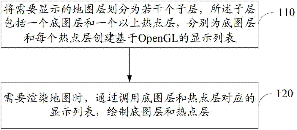
[0017] Please refer to figure 1 , the embodiment of the present invention also provides a GIS rendering method, comprising:

[0018] 110. Divide the map layer to be displayed into several sublayers, where the sublayers include a base layer and more than one hotspot layer, and create an OpenGL-based display list for the base layer and each hotspot layer respectively.

[0019] In this embodiment, the map layer to be displayed is divided into several sub-layers, and the sub-layers include at least two types of base layer and hotspot layer, and optionally, a third type of dynamic layer may also be included. The base layer contains the base map slice data of the map layer that needs to be displayed; the hotspot layer includes relatively stable map elements, specifically including points, lines, polygons, icons, and text labels; the dynamic layer includes map elements that need to be updated frequently, specifically Can include points, lines, areas, icons and text. A display task ...

Embodiment 2

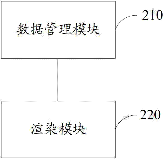
[0030] Please refer to figure 2 , the embodiment of the present invention also provides a GIS rendering system, including:

[0031] The data management module 210 is used to divide the map layer that needs to be displayed into several sublayers, and the sublayers include a base layer and more than one hotspot layer, and create an OpenGL-based display list for the base layer and each hotspot layer respectively ;

[0032] The rendering module 220 is configured to draw the base layer and the hotspot layer by calling the display lists corresponding to the base layer and the hotspot layer.

[0033] Optionally, the sub-layer may also include a dynamic layer; the rendering module 220 may also be used to directly draw each map element of the dynamic layer.

[0034] Optionally, in other implementation manners, the system may further include: an update module;

[0035] The update module is used to determine the sub-layer that needs to be updated and determine the type of the sub-lay...


PUM


Abstract

The invention discloses a rendering method of a geographic information system. The rendering method comprises dividing a map layer needing to be displayed into a plurality of sublayers which comprise bottom layers and more than one hot spot layers, respectively creating display lists based on an Open graphics library (GL) for the bottom layers and each hot spot layer, and drawing the bottom layers and the hot spot layers by invoking the display lists corresponding to the bottom layers and the hot spot layers when a map needs to be rendered. The invention further provides a corresponding system. When the map is displayed or renewed, only changed sublayers need to be processed, not all sublayers need to be processed, and therefore the consumed time in mapping is reduced, mapping efficiency is improved, and display effect is further improved.

Description

technical field [0001] The invention relates to the technical field of maps, in particular to a geographic information system rendering method and system. Background technique [0002] The rendering system of the Geographic Information System (GIS) is used to display various map elements such as basemaps, vectors, icons, texts, etc. on the video wall. At present, the GIS rendering system in the industry manages data according to the map layer, which contains various map elements that need to be rendered. [0003] Every data update of the map layer may trigger redrawing of the rendering system, reprocessing all data of the map layer. When performing GIS display on a high-resolution video wall, if there are many map layers to be drawn, and each map layer contains a large number of map elements, the drawing process will take a long time and the efficiency is very low, which will seriously affect the display effect . Contents of the invention [0004] Embodiments of the pre...

Claims


Application Information

Patent Timeline
IPC IPC(8): G09B29/00
Inventor 陈泓坤
Owner GUANGDONG VTRON TECH CO LTD
Why Eureka
Try Eureka