Antenna downward inclination angle determination method and device based on geographic information system (GIS)

A geographic information system and antenna downtilt technology, applied in wireless communication, electrical components, network planning, etc., can solve problems such as inaccurate propagation models, unreasonable overlapping areas between cells, and unreasonable radius calculations to improve network services Quality and user experience effects, avoiding the problem of edge cell throughput decline, and avoiding the effect of low resource utilization

Active Publication Date: 2013-07-03
CHINA MOBILE GROUP JIANGSU
View PDF4 Cites 32 Cited by
  • Summary
  • Abstract
  • Description
  • Claims
  • Application Information

AI Technical Summary

Problems solved by technology

Generally, a general-purpose propagation model is used, and the propagation model is corrected by adding the test data of a few local base stations in different scenarios to obtain a local propagation model. There is a problem of inaccuracy of the propagation model, which leads to unreasonable downtilt angle planning.
However, if 3D simulation is used, although the simulation effect is relatively good, it is time-consuming, laborious, and complicated to operate, and the simulation map needs to be continuously updated according to the actual intercity construction, and the investment cost is relatively high; if 2D simulation is used, it will lead to overlapping between cells The unreasonable area and the

Method used


Image

  • Antenna downward inclination angle determination method and device based on geographic information system (GIS)
  • Antenna downward inclination angle determination method and device based on geographic information system (GIS)
  • Antenna downward inclination angle determination method and device based on geographic information system (GIS)

Examples


Embodiment Construction
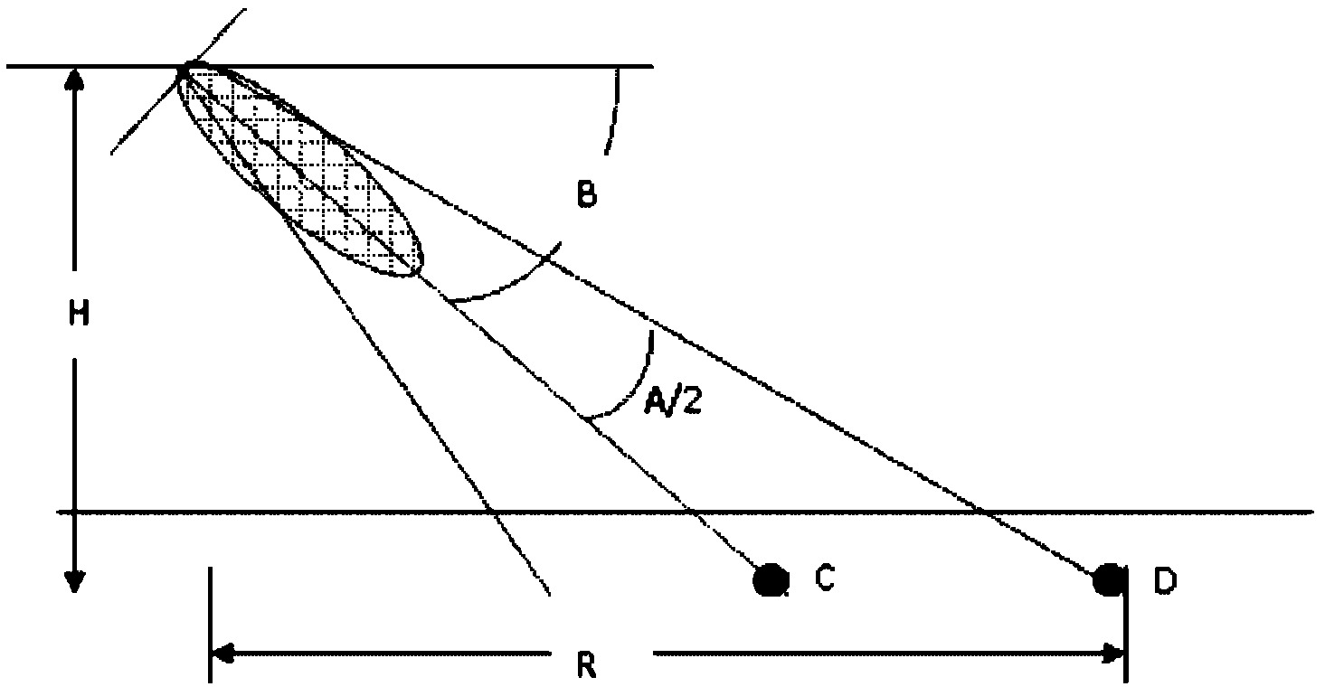
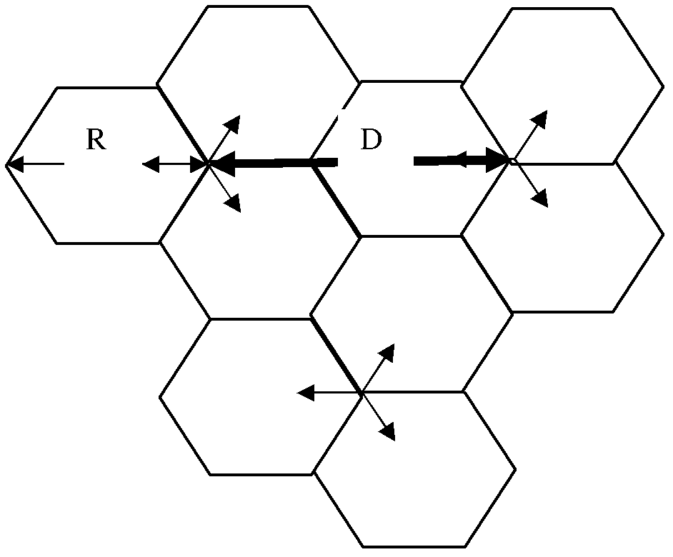
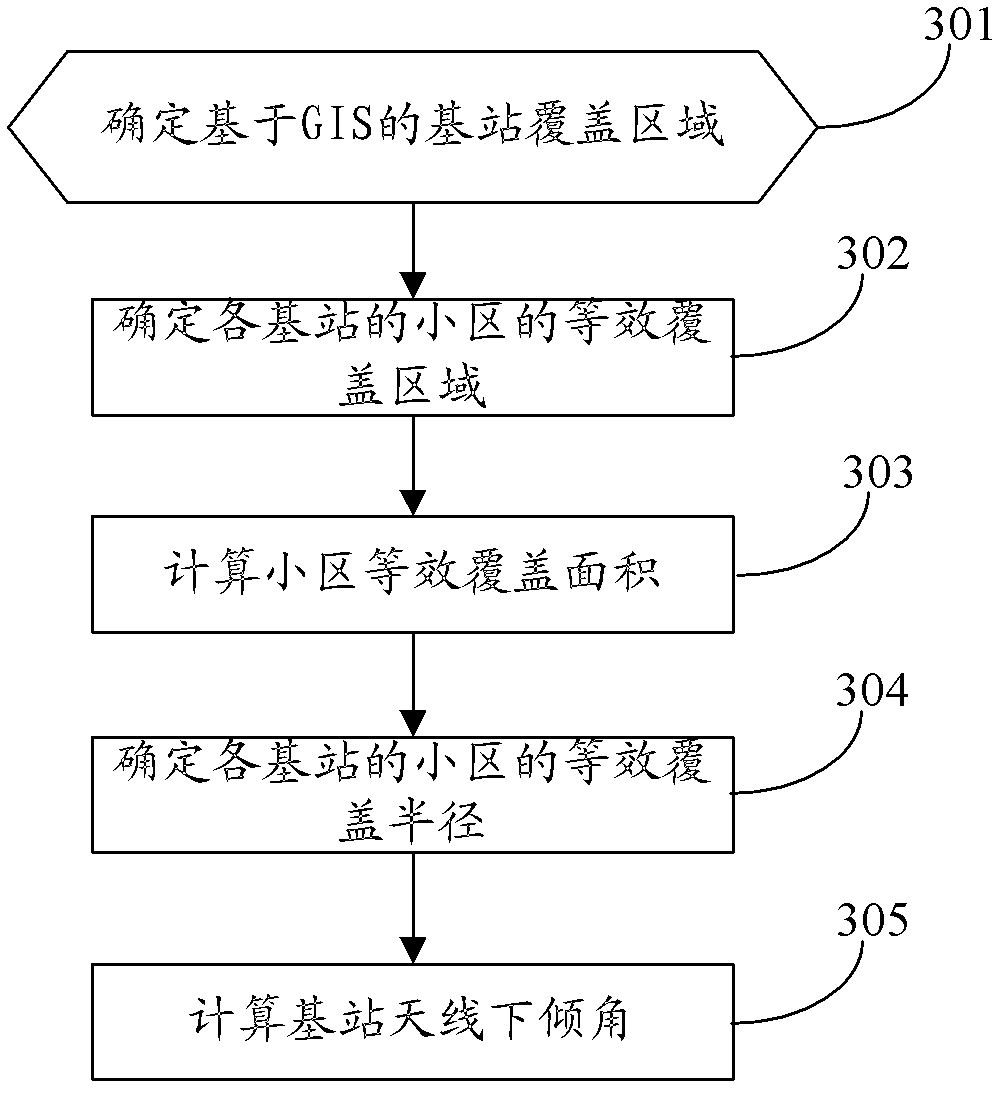
[0086] The basic idea of ​​the present invention is: determine the equivalent coverage radius of the cells of each base station according to the base station location information in the geographic information system GIS and the Thiessen polygon principle; The maximum coverage radius of each base station cell; when determining that the equivalent coverage radius is less than or equal to the maximum coverage radius, determine the antenna downtilt angle of the base station to which the cell belongs with the equivalent coverage radius; determine that the equivalent coverage radius is greater than When the maximum coverage radius is used, the antenna downtilt angle of the base station to which the cell belongs is determined according to the maximum coverage radius.

[0087] In order to make the object, technical solution and advantages of the present invention clearer, the present invention will be further described in detail by citing the following embodiments and referring to the ...


PUM


Abstract

The invention discloses an antenna downward inclination angle determination method and device based on a geographic information system (GIS). The method comprises the following steps: determining an equivalent coverage radius of a cell of each base station according to base station location information in the GIS and the Thiessen polygon principle and determining a maximum coverage radius of the cell of each base station according to an application scene which the cell of each base station is located in; when the equivalent coverage radius is ascertained to be smaller than or equal to the maximum coverage radius, determining the antenna downward inclination angle of the base station which the cell belongs to based on the equivalent coverage radius; and when the equivalent coverage radius is ascertained to be larger than the maximum coverage radius, determining the antenna downward inclination angle of the base station which the cell belongs to based on the maximum coverage radius. According to the technical scheme of the antenna downward inclination angle determination method and device based on the GIS, the problems, that handling capacity in a border cell is reduced and a resource usage ratio is low, caused by unreasonable arrangement of the antenna downward inclination angle of the base station in same-frequency networking in a time division-long term evolution (TD-LTE) system can be avoided, same and adjacent channel interference among cells can be reduced effectively and network service quality and user experience effects are improved.

Description

technical field [0001] The present invention relates to a base station antenna downtilt determination technology, in particular to a method and device for determining an antenna downtilt based on a geographic information system (GIS, Geographic Information System). Background technique [0002] Antenna downtilt setting and antenna downtilt adjustment are very important tasks in network planning and network optimization. Choosing an appropriate downtilt angle can make the ray from the antenna to the boundary of the cell and the ray from the antenna to the boundary of the interfered cell be in the part of the antenna vertical pattern with the largest change in gain attenuation, so that the same-frequency and adjacent-frequency interference of the interfered cell Minimize; In addition, select the appropriate coverage area, so that the actual coverage area of ​​the base station is the same as the expected design area, and at the same time strengthen the signal strength of the co...

Claims


Application Information

Patent Timeline
IPC IPC(8): H04W16/18H04W16/24
Inventor 蔡伟明陶建华张桂荣刁一新邱玉良吕艳艳
Owner CHINA MOBILE GROUP JIANGSU
Why Eureka
Try Eureka