Three-dimensional horizontal geological section map manufacturing method and applications thereof

A technology of horizontal section and horizontal geology, applied in image data processing, 3D modeling, instruments, etc., can solve problems such as inability to effectively reflect the overall geological distribution, large randomness of technical quality, lack of technical quality assurance, etc.

Active Publication Date: 2013-09-04
陈超东
View PDF4 Cites 46 Cited by
  • Summary
  • Abstract
  • Description
  • Claims
  • Application Information

AI Technical Summary

Problems solved by technology

The vertical geological section can only describe the stratum distribution on a certain vertical plane, and cannot effectively reflect the overall geological distribution on different elevations and horizontal planes. Provide comprehensive and effective technical support
[0004] 2. The existing two-dimensional engineering geological vertical section is only analyzed based on the boreholes at both ends of the section; and the stratum distribution in the middle of the two ends of the borehole has nothing to do with the distance between the boreholes, so in essence Just the trend stratigraphic distribution between two boreholes; cross-engineering vertical sections are often ambiguous
[0005] 3. Engineering designers can only grasp the general geological conditions based on geological survey data, and cannot comprehensively, accurately, clearly and intuitively analyze the horizontal plane of geological bodies. Faced with huge and complicated data, the geological conditions mastered by engineering and technical personnel are Large deviations and omissions from the actual geological and stratigraphic conditions are not conducive to scientific, quality and quantity, and economical processes in engineering survey, design, construction, monitoring, operation, and energy and mineral exploration, design, mining, and restoration.
[0006] 4. In the process of existing engineering survey and design or energy and mineral development, sporadic engineering and technical personnel construct schematic horizontal geological sections through manual interaction according to special application requirements; but the production cycle of this horizontal geological section is long and the cost is low. Large, random technical quality and lack of systematic technical quality assurance, it is not yet a necessary result type in engineering survey, design, construction, monitoring, operation and energy and mineral exploration, design, mining, restoration, etc.

Method used


Image

  • Three-dimensional horizontal geological section map manufacturing method and applications thereof
  • Three-dimensional horizontal geological section map manufacturing method and applications thereof
  • Three-dimensional horizontal geological section map manufacturing method and applications thereof

Examples


Embodiment 1

[0146] Horizontal profile of engineering geology of a project in Beijing.

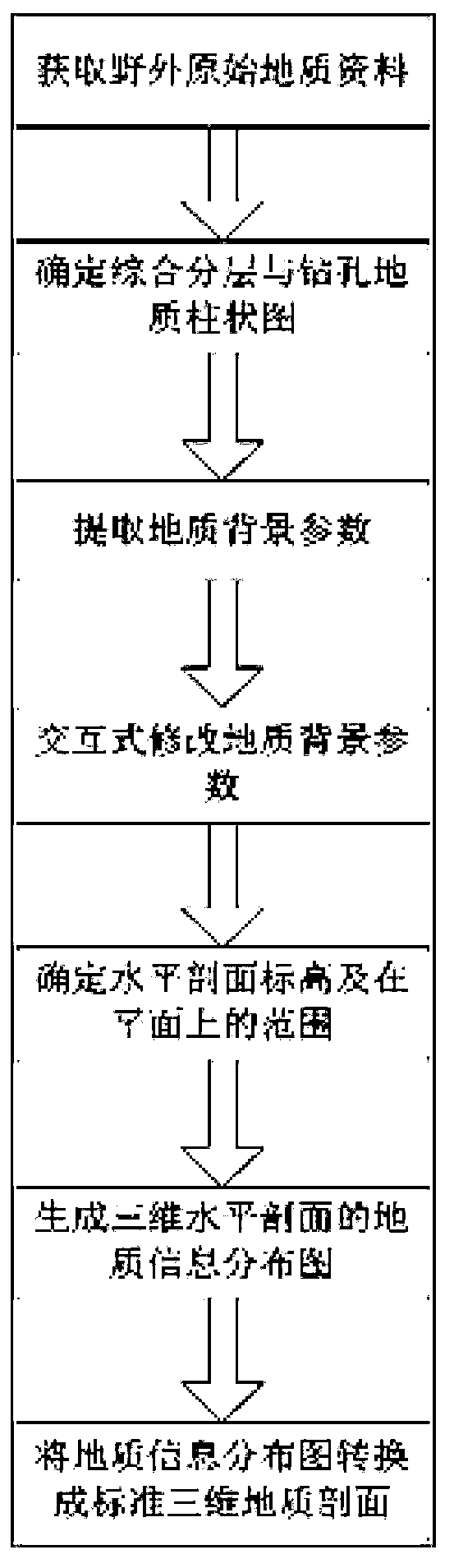
[0147]1. According to the requirements of technical specifications related to energy, mineral geology and engineering geology, obtain field geological raw data, including but not limited to drilling geological data, three-dimensional position information of drilling points, geological and geophysical prospecting information, and related indoor and outdoor test data.

[0148] In this project, it is mainly drilling data, and the text format of the data is described as follows:

[0149] The txt text is used as the data input carrier, and the data is divided into 7 columns. The first column is the serial number (number) of the drilling number, the second column is the drilling number (any character), and the third column is the drilling number in the X direction. Coordinates (numbers), the fourth column is the coordinates (numbers) in the Y direction of the borehole, the fifth column is the elevation value...


PUM


Abstract

The invention discloses a three-dimensional horizontal geological section map manufacturing method and applications of the three-dimensional horizontal geological section map manufacturing method. The method comprises the steps of obtaining wild geological raw data according to relevant correlation technical standard requirements of energy mineral resource geology and engineering geology, wherein the wild geological raw data comprise but not limited to drilling geological data, drilling point three-dimensional position information, geophysical exploration information and relevant indoor and outdoor testing data. The total number of the steps is ten. The method is applied to engineering geological map manufacturing and energy mineral resource geological map manufacturing, and geological mapping result expressing in geological mapping in the engineering geology and the energy mineral resource geology, wherein the geological mapping result expressing comprises but not limited to relevant mapping result expressing in the links of engineering geological mapping, designing, analyzing, constructing, monitoring and running and relevant mapping result expressing in the links of energy mineral resource planning, mapping, designing, monitoring, exploiting, running and repairing.

Description

technical field [0001] The invention relates to geological engineering information contained in a three-dimensional horizontal geological profile, a production method and its application, specifically a method for producing a three-dimensional horizontal geological profile and its application. The three-dimensional horizontal geological profile is used for the mapping of energy mineral geology and engineering geology, the expression of geological survey results in geological surveys in engineering geology and energy mineral geology, the expression of survey results in design, analysis, and construction related to geotechnical engineering and energy The expression of survey results in mining-related design, mining, and restoration. Background technique [0002] At present, there is no systematic horizontal geological section drawing technology, and there is no systematic horizontal geological section applied to energy and mineral geology and engineering geological mapping. T...

Claims


Application Information

Patent Timeline
Patent Type & Authority Applications(China)
IPC IPC(8): G06T17/00
Inventor 陈超东杨宇文张乐陈江河彭锲
Owner 陈超东
Why Eureka
Try Eureka