Automatic ortho-rectification frame and method for dynamically extracting remote sensing satellite image of image control points

An image control and dynamic extraction technology, applied in image enhancement, image analysis, image data processing, etc., can solve the problems of matching control point slices with images, small number of control point slices, low distribution density, etc.

Active Publication Date: 2013-11-06
INST OF REMOTE SENSING & DIGITAL EARTH CHINESE ACADEMY OF SCI +1
View PDF2 Cites 24 Cited by
  • Summary
  • Abstract
  • Description
  • Claims
  • Application Information

AI Technical Summary

Benefits of technology

The technical effect described by this patented technology allows users to automatically create an improved system that uses images from previous systems instead of manually gathering new controls on them beforehand. This helps streamline processes while maintaining accuracy. Additionally, it enables remote storage of references used during corrections made through different sources like GIS databases or cloud computing resources. Overall, these improvements improve efficiency and precision in object recognition processing tasks such as shape analysis.

Problems solved by technology

Technological Problem addressed in this patents relates to acquiring accurate remotely imaged photosensitive surfaces without requiring extensive human effort input. Current methods involve either relying solely upon predefined rules derived through simulations or fitting detected values onto specific locations within each frame. These techniques result in poor quality results when applied over large distances because they rely heavily on subjective judgment rather than objective measurement standards. To address these issues, there was developed a technique called ghosted refinement where only relevant parts were captured while other parts remained outside.

Method used


Image

  • Automatic ortho-rectification frame and method for dynamically extracting remote sensing satellite image of image control points
  • Automatic ortho-rectification frame and method for dynamically extracting remote sensing satellite image of image control points
  • Automatic ortho-rectification frame and method for dynamically extracting remote sensing satellite image of image control points

Examples


Embodiment Construction

[0022] The present invention will be further described in detail through the embodiments below in conjunction with the accompanying drawings.

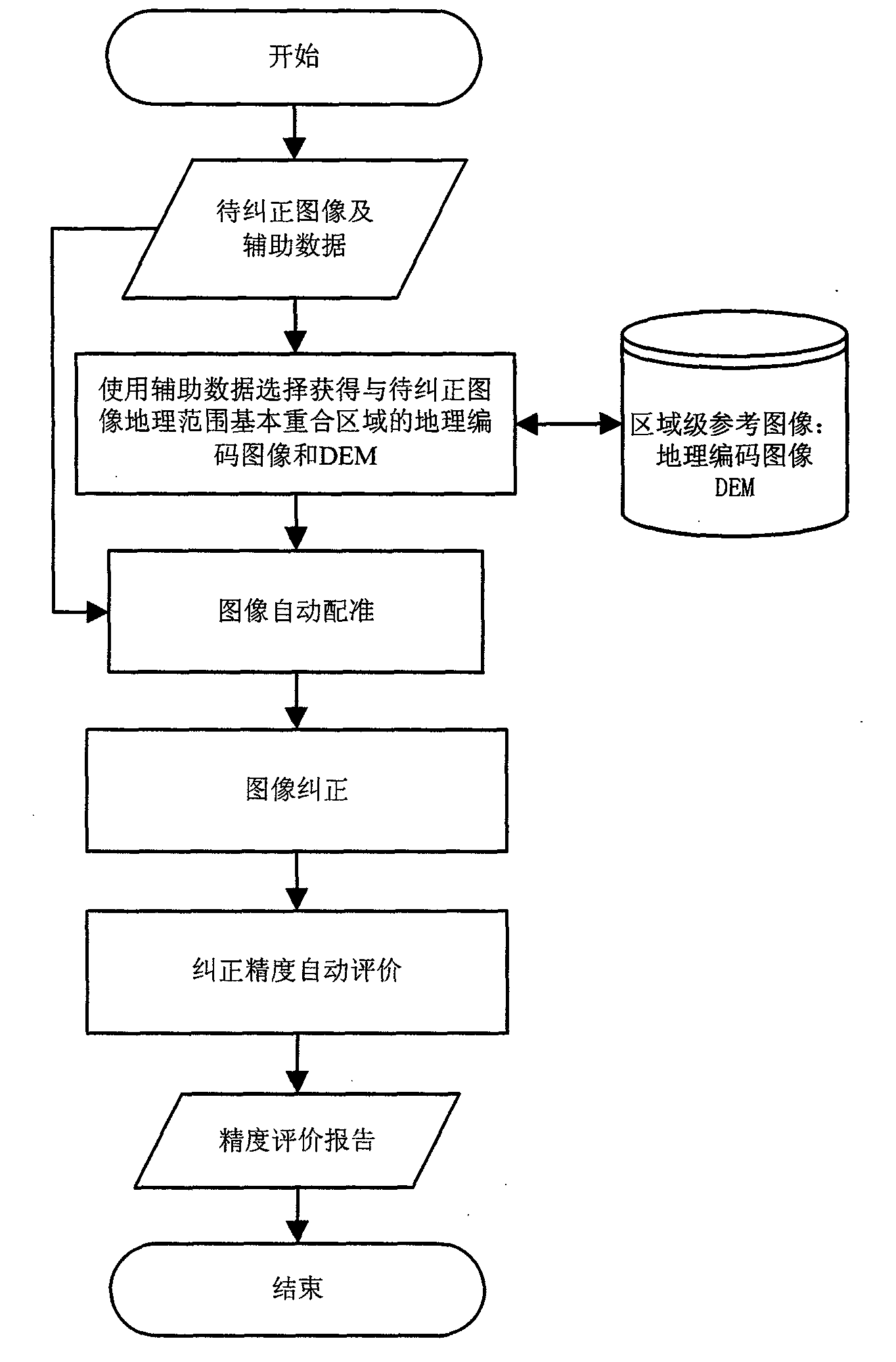
[0023] figure 1 It is the framework and basic flow chart of remote sensing image automatic correction. It includes a reference data set and an execution module for automatic geometric correction.

[0024] The reference data set includes two types of data: remote sensing images with accurate geocoding and DEM data in the same area. The range of data can be local area or global data, at least including the area to be corrected; remote sensing images with geocoding usually choose any After orthorectification, it is considered that the geometric accuracy meets the requirements and can be used as the image composition of the reference image.

[0025] The basic method of reference data set management is to slice and manage regional or global reference data according to geocoding. Divide regional data or global data into several data block...


PUM


Abstract

The invention provides an automatic ortho-rectification frame and method for dynamically extracting a remote sensing satellite image of image control points. The frame comprises a region level reference image set and an executing module which automatically conducts geometric correction on the remote sensing satellite image. The executing module automatically conducts geometric correction mainly through the four steps of firstly, through coordinate information of the four corner points of an image to be corrected and an estimated value of a system correction error, extracting a reference image which is basically overlapped with the image to be corrected in the aspect of the geographical range and a DEM, using the extracted reference image as a control image, and using data of the DEM for ortho-rectification correction; secondly, conducting automatic matching on the control image and the image to be corrected to obtain the control points; thirdly, setting up a correction model between the image to be corrected and the control image based on the control points, and conducting correction on the image to be corrected; fourthly, conducting automatic registration on the corrected image and the control image again through an image automatic matching method, and automatically calculating relative correction errors through the matched control points.

Description


Claims


Application Information

Patent Timeline
Owner INST OF REMOTE SENSING & DIGITAL EARTH CHINESE ACADEMY OF SCI
Why Eureka
Try Eureka