Complex heterogeneity forest stand mean height estimating method based on multisource remote sensing data

A technology of remote sensing data and forest stands, applied in the field of information, to achieve rich spectral information, true estimation results, and reliable estimation accuracy

Active Publication Date: 2014-02-05
BEIJING FORESTRY UNIVERSITY
View PDF0 Cites 12 Cited by
  • Summary
  • Abstract
  • Description
  • Claims
  • Application Information

AI Technical Summary

Problems solved by technology

[0003] In order to overcome the fixed compensation coefficient of the existing coherent phase-amplitude compensation method, ignoring the problems of stand heterogeneity and forest vertical

Method used


Image

  • Complex heterogeneity forest stand mean height estimating method based on multisource remote sensing data
  • Complex heterogeneity forest stand mean height estimating method based on multisource remote sensing data
  • Complex heterogeneity forest stand mean height estimating method based on multisource remote sensing data

Examples


Embodiment Construction

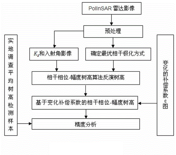
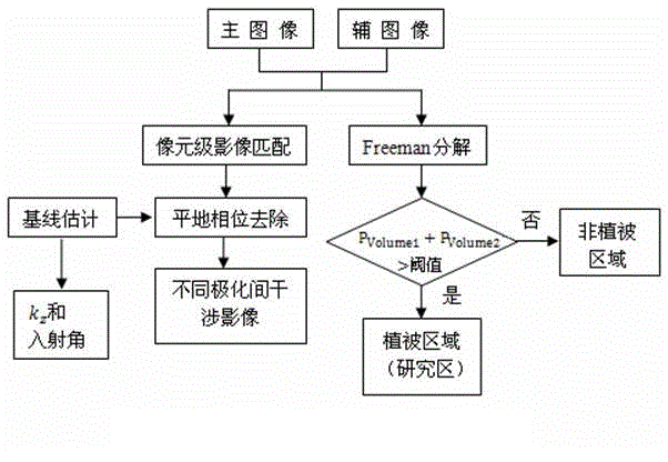
[0011] (1) Preprocess the radar data to obtain the interference image:

[0012] exist figure 2 In the shown embodiment, the input data source is two coherent SLC data in the study area, the SAR effect based on FFT transformation is used to automatically register the primary and secondary images, the nonlinear least square method is used for baseline estimation, and flat ground dephasing. Coherent images between different polarization modes are obtained by complex conjugate multiplication of the polarization modes, and the noise is reduced by the circular period median filter method.

[0013] (2) Classification of forest land and non-forest land:

[0014] exist figure 2 In the illustrated embodiment, Freeman decomposition is performed on the primary and secondary images respectively, and the volume scattering components of the two are combined to determine whether they belong to the vegetation area by using a threshold. If P Volume1 +P Volume2 >Threshold, it is judged as...


PUM


Abstract

The invention discloses a complex heterogeneity forest stand mean height estimating method based on multisource remote sensing data. The complex heterogeneity forest stand mean height estimating method is a multi-data source multi-kind information forest stand mean height estimating technology which integrates the phase and amplitude information of a polarization interference radar, vegetation index information, entropy information reflecting a forest structure, second class investigation information and sample-plot survey information. The spectral information and the structure complexity of a forest are reflected by introducing the vegetation index (NDVI) and the entropy in the information theory in the technology. According to specific forest conditions, different compensation factors are given to different forest stands, and a compensation factor function is established. A coherent phase-amplitude algorithm is improved by using the changed compensation factor after correction to replace a constant compensation factor. Large area, high precision and fast extraction and charting of the forest stand mean height of a complex forest structure in a cloud and rain area are achieved.

Description

technical field [0001] The patent of the invention relates to the phase and amplitude information of a comprehensive polarization interference radar, the vegetation index information extracted by Landsat8, the entropy value information reflecting the forest structure, the multi-data sources and multi-information forest stand average height of the second-class survey and plot survey data Estimation technology, especially the large-scale, high-precision, and fast extraction and mapping methods for the average height of forest stands in cloudy and rainy areas, has been greatly improved. Background technique [0002] At present, the well-known PolInSAR DEM difference method for estimating vegetation height is to separate the phase centers of various scattering mechanisms by effectively combining polarization information and interference technology, and then calculate the phase difference value of the phase centers representing the ground surface and vegetation Get the vegetation...

Claims


Application Information

Patent Timeline
IPC IPC(8): G01S13/88
CPCG01S13/882G01S13/9023G01S13/9076
Inventor 张晓丽赵明瑶白金婷王金兰
Owner BEIJING FORESTRY UNIVERSITY
Why Eureka
Try Eureka