Supercharge Your Innovation With Domain-Expert AI Agents!

Method and device for planning secure path of mobile terminal

A mobile terminal and security path technology, applied in the field of communications, can solve the problems of unsatisfactory overall performance, leakage of user location privacy, and no consideration of attack evasion.

Active Publication Date: 2015-06-03
CHINA UNITED NETWORK COMM GRP CO LTD
View PDF2 Cites 9 Cited by
  • Summary
  • Abstract
  • Description
  • Claims
  • Application Information

AI Technical Summary

Problems solved by technology

[0006] At present, there are not many methods with comprehensive location privacy performance. Most methods can only prevent certain types of attacks, and the overall performance is not satisfactory. In areas with strong attack capabilities, the user's location privacy may still be leaked
Moreover, the current approach is basically at the expense of positioning accuracy in exchange for the security of location privacy, and does not consider how to avoid attacks in path planning.

Method used


Image

  • Method and device for planning secure path of mobile terminal
  • Method and device for planning secure path of mobile terminal

Examples


Embodiment 1

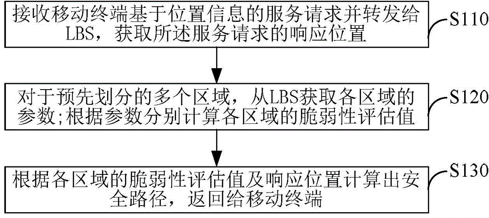
[0037] Embodiment 1. A safe path planning method for a mobile terminal, such as figure 1 shown, including:

[0038] S110. Receive the service request based on the location information of the mobile terminal and forward it to the location-based server LBS, and acquire the response location of the service request from the LBS;

[0039] S120. For multiple pre-divided areas, acquire parameters of each area from the LBS; the parameters include the area size of the area, the number of mobile terminals entering and leaving the area within a predetermined period of time, and each mobile terminal in the area at the current moment Customized expected privacy level; Calculate the vulnerability assessment value of each area according to the parameters;

[0040] S130. Calculate a safe path according to the vulnerability evaluation value and the response location of each area, and return it to the mobile terminal; the safe path is from the current location of the mobile terminal to the res...

Embodiment 2

[0054] Embodiment 2. A safety path planning device for a mobile terminal, comprising:

[0055] A location acquisition module, configured to receive a service request from a mobile terminal based on location information and forward it to a location-based server LBS, and obtain a response location of the service request from the LBS;

[0056] The evaluation module is used to obtain the parameters of each area from the LBS for multiple pre-divided areas; the parameters include the size of the area, the number of mobile terminals entering and leaving the area within a predetermined period of time, and the number of mobile terminals in the area at the current moment. The expected privacy level customized by each mobile terminal; the vulnerability evaluation value of each area is calculated respectively according to the parameters;

[0057] A path calculation module, configured to calculate a safe path according to the vulnerability evaluation value of each area and the response loc...

Embodiment 3

[0065] Embodiment 3. A safe path planning system for a mobile terminal, comprising:

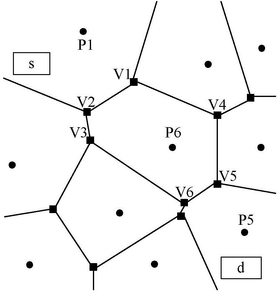
[0066] Location Based Server (LBS), Trusted Third Party (TTP) and Mobile Terminal. The functions of the three parts are: the user uses the mobile phone as a mobile terminal to propose services based on geographical location information; TTP is a key part of the system, and its main function is to realize the anonymous operation of the service request submitted by the user and the vulnerability assessment of the system Work and dynamic route planning work; LBS provides services based on geographic location information, such as responding to the geographic location coordinates of the nearest restaurant, sending real-time traffic information, etc.

[0067] The workflow of the whole system can be roughly divided into six steps, the specific steps are as follows:

[0068] ① The user puts forward a service request based on location information through the mobile terminal, such as finding the neare...


PUM


Abstract

The invention provides a method and device for planning the secure path of a mobile terminal. The method comprises the following steps: receiving a service request, based on position information, of the mobile terminal, transmitting the service request to an LBS, and obtaining the response position of the service request from the LBS; obtaining the parameters of a plurality of pre-partitioned areas from the LBS; respectively calculating the vulnerability assessed values of the areas according to the parameters; calculating the secure path according to the vulnerability assessed values of the areas and the response position, and returning to the mobile terminal, wherein the secure path is a path with the minimum sum of reciprocals of the vulnerability assessed values of the areas from the current position of the mobile terminal to the response position. The factors such as communication foundation setting, path distribution and distribution of the mobile terminal in specific geographic areas are comprehensively considered, and a secure, reliable and accurate path planning scheme is provided for mobile users.

Description

technical field [0001] The present invention relates to the communication field, in particular to a method and device for planning a safe path of a mobile terminal. Background technique [0002] With the continuous development of positioning technology, mobile communication technology and smart phone platform (mobile terminal platform), service technology based on geographic location information has emerged as the times require. This technology can provide geographic location information services for mobile users, and users only rely on vehicle-mounted systems (Smartphone) can enjoy geographic information services anytime and anywhere, such as querying the nearest movie theater, querying the shortest path to a certain park, making friends according to geographic location, etc. Although this kind of service and positioning technology provides great convenience for mobile users, it needs to obtain the precise location information of mobile users before using it, and the locati...

Claims


Application Information

Patent Timeline
Patent Type & Authority Applications(China)
IPC IPC(8): H04W4/02
Inventor 陈晓杰
Owner CHINA UNITED NETWORK COMM GRP CO LTD
Features
  • R&D
  • Intellectual Property
  • Life Sciences
  • Materials
  • Tech Scout
  • Unparalleled Data Quality
  • Higher Quality Content
  • 60% Fewer Hallucinations
Learn More