Earthquake acquisition management system and method through technology of network cloud

A management system and cloud technology, which is applied in the field of seismic acquisition construction network technology management system, can solve the problems of complex field construction sites, no stake number at the excitation point, and error-prone, so as to improve the level of seismic acquisition management and save labor cost effect

CN104820900AInactive Publication Date: 2015-08-05孙素梅
3 Cites 7 Cited by

Patent Information

Authority / Receiving Office
CN · China
Patent Type
Applications(China)
Current Assignee / Owner
Publication Date
2015-08-05
Estimated Expiration
Not applicable · inactive patent

Smart Images

  • Figure 1
    Figure 1
Patent Text Reader

Abstract

The invention relates to an earthquake acquisition management system and method through the technology of network cloud. The system comprises a cloud server, a computer main system, an acquisition and navigation client, a well-drilling management client, a blasting management client, and a supervising management client. Through monitoring and recording the working conditions of all construction clients, managers at all stage achieve the management of the whole construction process. The system achieves the positioning and collection of construction data through GPS positioning in a process of construction, achieves the real-time monitoring of the whole construction process through the technology of network, unifies the dispatching, and achieves accurate and high-efficiency purposes.
Need to check novelty before this filing date? Find Prior Art

Description

technical field

[0001] The invention relates to a construction network technology management system and method for seismic acquisition operations. Background technique

[0002] At present, the seismic acquisition of geophysical exploration adopts the following methods:

[0003] 1. According to the requirements of Party A, the interpreter designs the theoretical SPS and calculates the construction scope;

[0004] 2. The surveyor conducts measurement according to the designed SPS. At the design position, if the shot can be shot, the stake number, including the line number and point number, will be marked by piling. Otherwise, the obstacle area will be marked, and as many points as possible should be measured on both sides of the obstacle area where the shot can be fired. ;

[0005] 3. The interpreter designs the excitation point offset based on the measurement results. Output preliminary construction SPS;

[0006] 4. Relevant personnel conduct on-site survey and confirmati...

Examples

Embodiment Construction

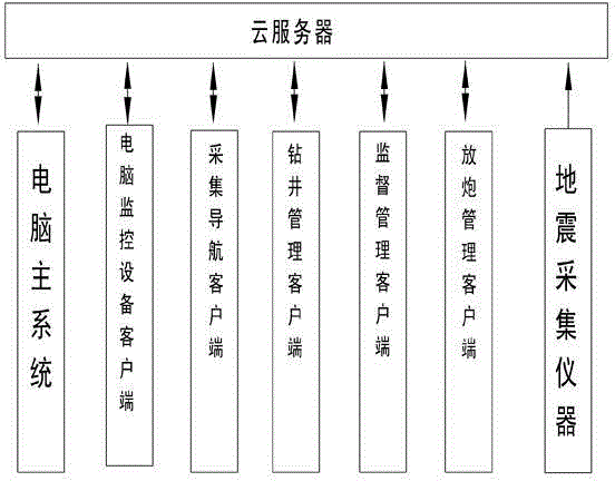
[0067] Seismic acquisition network cloud technology management system, including:

[0068] Cloud server, including data management module and data transmission module; used to mount user data, computer main system, acquisition and navigation client, drilling management client, blasting management client, supervision management client to process uploaded data, save and distribute related data;

[0069] Computer main system, including user identity verification module and data processing module; used for user and authority management, defining work area boundaries, loading SPS, measuring point data, well depth design data, etc., generating and uploading work area maps and navigation data to the cloud server, from The cloud server downloads user location information, drilling and blasting data, and generates various reports; downloads each user's route track and browses the track;

[0070] Acquisition and navigation client, including user identity verification module, data trans...