Electronic map sign drawing system and method for city street lamps

An electronic map and city technology, applied in the field of electronic map marking system, can solve problems such as failure to meet actual needs, mutual coverage or occlusion, and slow symbolization of urban street lights.

Active Publication Date: 2016-03-09
TAIHUA WISDOM IND GRP CO LTD
View PDF4 Cites 6 Cited by
  • Summary
  • Abstract
  • Description
  • Claims
  • Application Information

AI Technical Summary

Problems solved by technology

The limitations of general-purpose GIS in the intelligent lighting of urban street lights are mainly manifested in the lack of models and symbolic signs applied to intelligent lighting of urban street lights. The existing symbolic signs are far from meeting the actual needs.
Therefore, the general-purpose GIS has great defects in the display of urban street lighting.
[0005] 2. Manually drawing urban street lamp symbolic signs is slow, heavy workload, and the standardization of signs is not high
For medium pole lights, high pole lights and other types of light poles with more lamp heads, the number of icons that need to be marked will be very large. If all these status icons are drawn manually, the workload of making icons will be huge and time-consuming Many, imprecise issues, and when updates are required, updates are cumbersome and slow
[0007] 3. The resource information display of street lighting facilities cannot be displayed in detail, and the loading is slow
[0008] When using GIS to display street lighting facilities information, due to the influence of the density of light poles and the scale of the map, traditional GIS does not have a good method for displaying a large number and variety of street lighting equipment in terms of details and appropriateness
[0009] When the map scale is large, the street light equipment information within the visible range of the map is as simple as that displayed when the map scale is small, and more detailed street light facility information should be displayed at this time; when the map scale is small, the visible range of the map is larger. There are a large number of street lighting facilities within the visible range, and all reading and loading from the database will result in slow data loading and reduce user experience; after loading and displaying, the display density in the visible range of the map is too high, causing the icons to overlap or block each other. Cannot distinguish street lighting facilities, affecting viewing effect
[0010] 4. The information display of street light facility resources is not intuitive and slow
With the expansion of the city, the number of street lighting facilities is increasing exponentially. Faced with such a large amount of facility data and complicated equipment types, when the existing street lighting facility management system displays street lighting facilities, it can display lists and icons, which are effective. Unintuitive, slow data loading and display speed, etc.

Method used


Image

  • Electronic map sign drawing system and method for city street lamps

Examples


Embodiment Construction

[0065] The present invention will be further described below in conjunction with the accompanying drawings and specific embodiments.

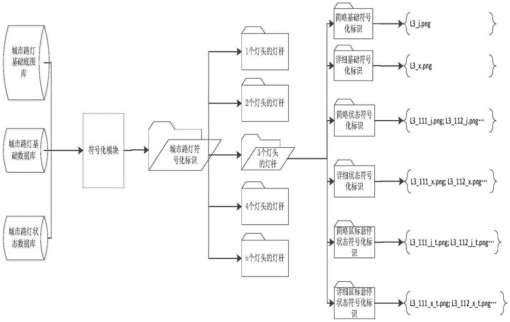
[0066] An electronic map marking system for urban street lamps, such as figure 1 As shown, including: sequentially connected data generation module, data city streetlight database and symbolization module;

[0067] The data generation module collects all types of basic base maps, basic data and status data of urban streetlight facilities in the urban streetlight control box or urban streetlight resource monitoring system and stores them in the data urban streetlight database;

[0068] The data urban street lamp database includes:

[0069] Urban street light foundation base library: used to store the base base map pre-made according to the basic attributes of urban street lights;

[0070] Urban street lamp basic database: used to store basic data information of urban street lamp facilities;

[0071] Urban street lamp status database: used to ...


PUM


Abstract

The present invention discloses an electronic map sign drawing system and method for city street lamps. The system comprises: a data generation module, a digital city street lamp database, a symbolization module, and a data displaying module which are sequentially connected. The digital city street lamp database comprises: a city street lamp base map library, a city street lamp basic database, and a city street lamp state database. The symbolization module comprises: a data reading module, a city street lamp symbolized sign generation module, and a city street lamp symbolized sign file system. The symbolization module generates symbolized signs of city street lamps in an electronic map, and stores the generated symbolized signs into the city street lamp symbolized sign file system according to classifications. The effect of the system and method provided by the present invention is that a large quantity of required state symbolized signs of city street lamps can be rapidly drawn and stored by using the drawing system, and the signs can be completely and visually displayed in a street lamp facility monitoring and management system in a timely manner and in proper details by using a GIS.

Description

technical field [0001] The invention relates to an electronic map sign drawing system and method for urban street lamps. Background technique [0002] With the development of science and technology, the application of GIS system in the monitoring and management of street lighting facilities is becoming more and more frequent. It can perform geographical display, information monitoring, management and control of street lighting facilities, timely remote measurement of street lighting facility operation data, and real-time operation information. Perform functional operations such as analysis and processing, timely storage of measured data, real-time operation data GIS display, and historical data GIS display. Through the combined use of the street lamp facility operation monitoring management system and GIS, the public utility street lamp management department and the street lamp industry operation and maintenance department have a good improvement in the display of street lam...

Claims


Application Information

Patent Timeline
Patent Type & Authority Applications(China)
IPC IPC(8): G06F17/30
CPCG06F16/29
Inventor 徐文鹏杜伟洪之旭尚宪斌马述杰庄绪良郝敬全蒋德民修择吕令敏张超
Owner TAIHUA WISDOM IND GRP CO LTD
Why Eureka
Try Eureka