Method for generating three-dimensional geological map based on geological route (PRB) process double modeling

A 3D geology and geological map technology, applied in 3D modeling, image data processing, special data processing applications, etc., can solve the problems of unsynchronized regional mineral survey, low modeling efficiency, and efficiency hindering application, etc.

Active Publication Date: 2016-04-06
中国地质调查局自然资源综合调查指挥中心
View PDF5 Cites 22 Cited by
  • Summary
  • Abstract
  • Description
  • Claims
  • Application Information

AI Technical Summary

Problems solved by technology

[0004] However, the above modeling techniques have the following problems: 1) The modeling process cannot be synchronized with regional geological surveys and regional mineral surveys, that is, real-time modeling cannot be pe...

Method used


Image

  • Method for generating three-dimensional geological map based on geological route (PRB) process double modeling
  • Method for generating three-dimensional geological map based on geological route (PRB) process double modeling
  • Method for generating three-dimensional geological map based on geological route (PRB) process double modeling

Examples


Embodiment Construction

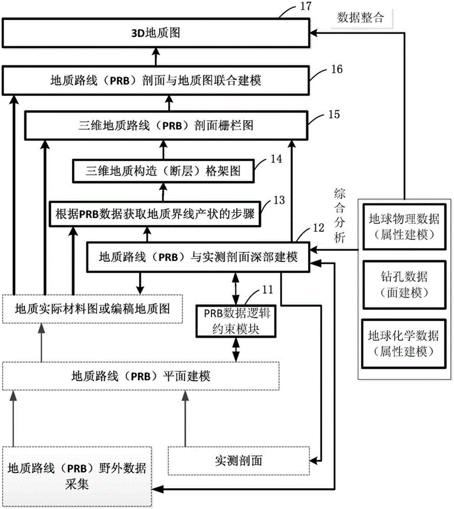
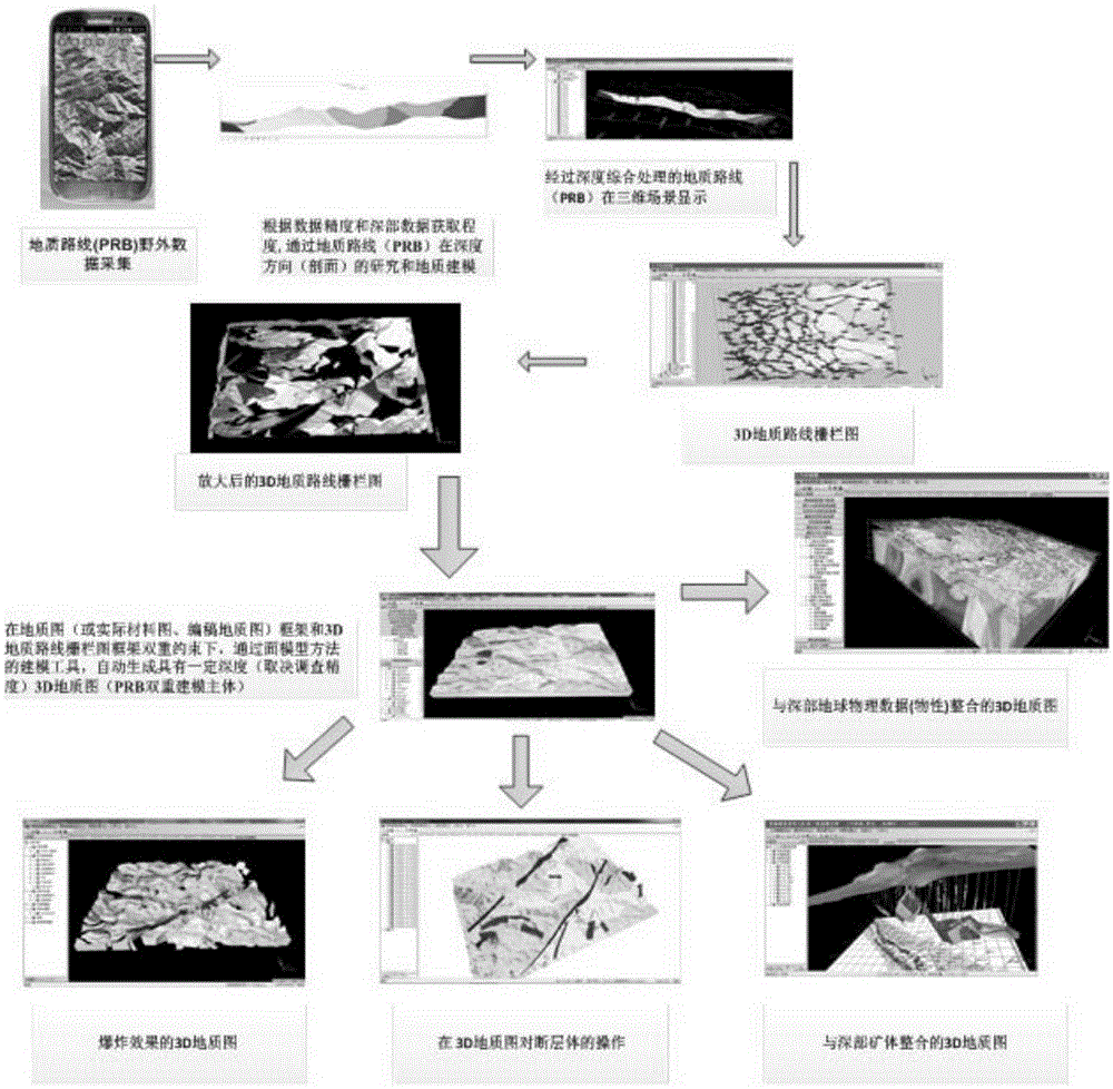
[0059] The method for generating a three-dimensional geological map by dual modeling of the geological route (PRB) process of the present invention will be further described in detail below in conjunction with the accompanying drawings and the embodiments of the present invention.

[0060] The invention is a modeling method starting from the field geological route and the three-dimensional geological mapping modeling of the measured geological section. Through the research and geological modeling of geological routes in the horizontal direction (that is, the plane) and the depth direction (that is, the section), the geological map is dynamically generated, and on this basis, under the dual constraints of the geological map frame and the route profile frame, through the surface model The modeling tool of the method automatically generates a 3D geological map with a certain depth. It can be applied to technical fields such as 3D regional geological survey and mineral geological ...


PUM


Abstract

The present invention discloses a method for generating a three-dimensional geological map based on geological route (PRB) process double modeling. The method comprises a step of carrying out PRB field data collection and the PRB modeling of a measured section and a step of obtaining a geological actual material map or a manuscript geological map according to the PRB modeling, and the method also comprises the steps of (A) carrying out logical constraint on the PRB section, (B) carrying out deep modeling on the PRB and the measured section, (C) obtaining a geological boundary occurrence according to the PRB data, (D) generating a three-dimensional geological structure /fault framework diagram, (E) generating a three-dimensional PRB section fence diagram, (F) carrying out PRB section and geological map combined modeling, and (G) generating the three-dimensional geological map. By using the method, a three-dimensional modeling process and a digital area geological survey process can be synchronized, the modeling is carried out from the synchronization of the three-dimensional modeling process and the measured geological section collection synchronization, and the modeling efficiency is greatly improved.

Description

technical field [0001] The invention relates to the application field of three-dimensional geological mapping technology, in particular to a method for generating a three-dimensional geological map based on dual modeling of a geological route (PRB) process. Background technique [0002] Three-dimensional geological mapping modeling of field geological routes and measured geological sections is a modeling method applied to three-dimensional regional geological surveys and mineral geological surveys. Through the research and geological modeling of the geological route in the horizontal direction (plane) and depth direction (section), the geological map is dynamically generated, and on this basis, under the dual constraints of the geological map frame and the route profile frame, through the surface model method A modeling tool that automatically generates 3D geological maps with a certain depth. [0003] At present, in terms of 3D mapping, the general status of international ...

Claims


Application Information

Patent Timeline
IPC IPC(8): G06T17/05G06F17/50
Inventor 李超岭李丰丹刘畅刘园园李健强吕霞
Owner 中国地质调查局自然资源综合调查指挥中心
Why Eureka
Try Eureka