Remote sensing retrieval method for moisture of farmland soil

A soil moisture and remote sensing inversion technology, applied in the field of farmland soil moisture remote sensing inversion, can solve problems such as high requirements for land cover types, difficulty in estimating regions, and uncertainty

Active Publication Date: 2016-04-20
BEIJING NORMAL UNIVERSITY
View PDF4 Cites 17 Cited by
  • Summary
  • Abstract
  • Description
  • Claims
  • Application Information

AI Technical Summary

Problems solved by technology

[0012] The Temperature Vegetation Dryness Index (TVDI) based on the Vegetation Index-Surface Temperature (VI-Ts) feature space is widely used in soil moisture monitoring, but there are two shortcomings: (1) High requirements on the type of land cover
Theoretically, the TVDI feature space should include three vegetation coverage conditions: bare soil, partial vegetation coverage, and full vegetation coverage, which makes it difficult to estimate areas with simple coverage types. In essence, it is only the edge existing in the feature space, rather than the theoretical dry and wet edge, so it causes great uncertainty; (2) TVDI is the relative value of soil moisture, which needs to be corrected to the estimated value of soil moisture after observation

Method used


Image

  • Remote sensing retrieval method for moisture of farmland soil
  • Remote sensing retrieval method for moisture of farmland soil
  • Remote sensing retrieval method for moisture of farmland soil

Examples


Embodiment Construction

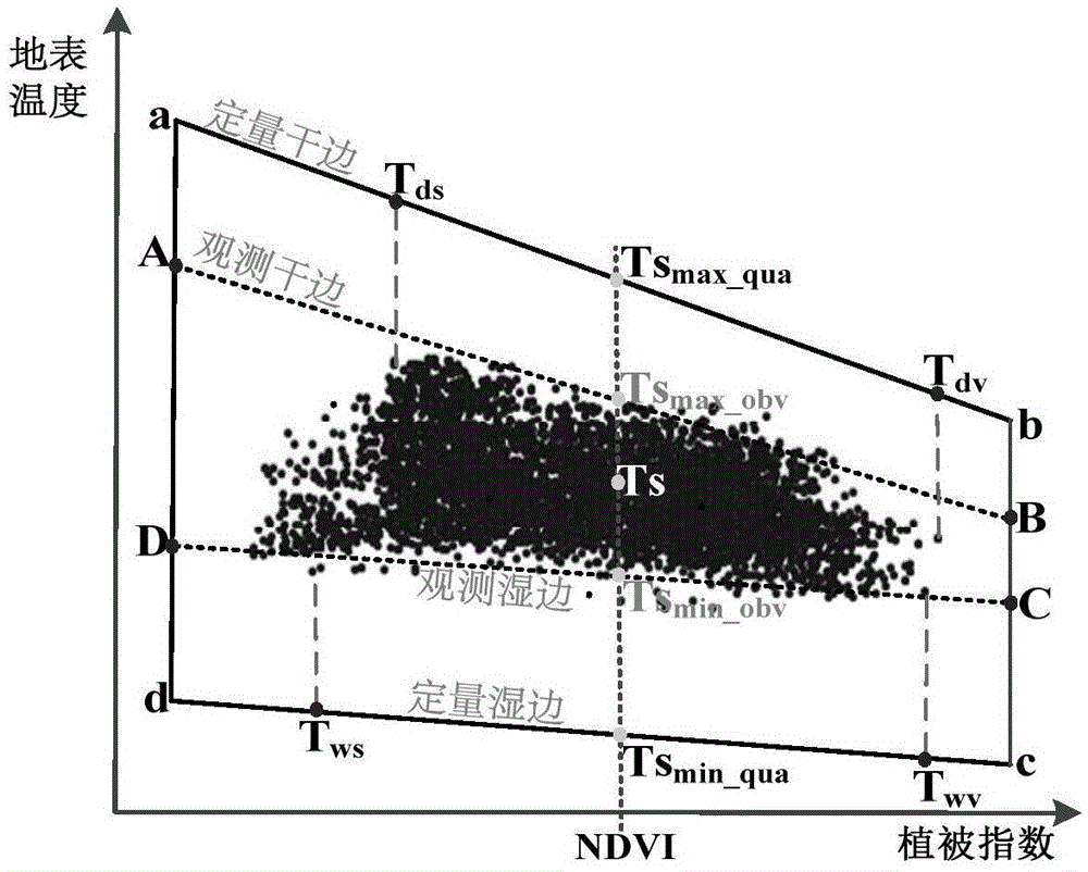
[0039] TVQI Calculation Method

[0040] The present invention constructs the VI-Ts feature space based on the surface energy balance theory ( figure 2 Where ab is the quantitative dry edge, cd is the quantitative wet edge), and the estimated value of soil moisture is expressed based on the quantitative dry and wet edge and the TVQI model of improved TVDI, and the calculation formula is as follows:

[0041] T V Q I = Ts m a x _ q u a - T s Ts m a x _ q u a ...


PUM


Abstract

The invention discloses a remote sensing retrieval method for moisture of farmland soil. The method is based on an energy-balance equation and TVDI, and provides a quantitative dry and wet edges determination method and an improved TVQI model-temperature vegetation quantitative index (TVQI). The method is characterized in that A) forming a vegetation index-ground temperature characteristic space based on a remote sensing image observation value, according to the surface energy-balance equation, obtaining a quantitative dry edge, wherein the quantitative dry edge is determined by two points of Tds and Tdv; B) obtaining the quantitative wet edge, wherein the quantitative wet edge is determined by two points of Tws and Twv; and C) according to the TVQ1 model, calculating a soil moisture estimate value. The method overcomes restriction of vegetation cover types in calculation of VI-Ts characteristic space, and remote sensing retrieval precision of soil moisture can be increased.

Description

technical field [0001] The invention relates to a farmland soil moisture remote sensing inversion method, in particular to a farmland soil moisture remote sensing inversion method based on an improved temperature vegetation drought index. Background technique [0002] Moisture is an important part of the earth system and plays a comprehensive role in various physical geography research areas. Soil moisture in farmland is of great significance to the growth and yield of crops. The method of using remote sensing to monitor surface soil moisture has the advantages of wide range, high efficiency, and continuous time. At present, soil moisture remote sensing monitoring methods based on visible light-near infrared and thermal infrared bands mainly include vegetation index method, surface temperature method, and feature space method. The vegetation index method indirectly reflects the water supply status of the soil through the response of the vegetation in the sensitive band. It ...

Claims


Application Information

Patent Timeline
Patent Type & Authority Applications(China)
IPC IPC(8): G01N21/17
CPCG01N21/17G01N2021/1793
Inventor 宫阿都单越苏永荣尹晓天吕潇然李静
Owner BEIJING NORMAL UNIVERSITY
Why Eureka
Try Eureka