Check patentability & draft patents in minutes with Patsnap Eureka AI!

Downhole positioning method based on combination of geomagnetism and rfid radio frequency

A geomagnetic and radio frequency technology, used in ground navigation, earth-moving drilling, mining equipment, etc., can solve the problems of low positioning accuracy, inaccurate positions of underground personnel, and inability to complete the positioning of underground personnel, so as to improve positioning accuracy and positioning effectiveness. strong effect

Active Publication Date: 2018-08-31
NORTH CHINA UNIVERSITY OF SCIENCE AND TECHNOLOGY
View PDF4 Cites 2 Cited by
  • Summary
  • Abstract
  • Description
  • Claims
  • Application Information

AI Technical Summary

Problems solved by technology

Under normal underground production conditions, mine monitoring equipment can monitor the location and movement trajectory of underground personnel, but underground personnel cannot obtain their own spatial coordinates in real time, analyze the optimal path for avoidance or rescue, and cannot realize positioning and navigation according to needs
This underground positioning technology completely depends on the transmission and reception of network power. Once a disaster occurs underground, power supply interruption or signal interruption, it will be impossible to complete the positioning of underground personnel and realize real-time navigation in the process of avoiding danger or rescue.
The accuracy of this existing positioning method depends on the installation interval of the roadway radio frequency information collector, the calculated position of underground personnel is inaccurate, and the positioning accuracy is not high

Method used


Image

  • Downhole positioning method based on combination of geomagnetism and rfid radio frequency

Examples


Embodiment Construction

[0028] The present invention will be further described below in conjunction with the accompanying drawings and embodiments, but the embodiments do not constitute any limitation to the present invention.

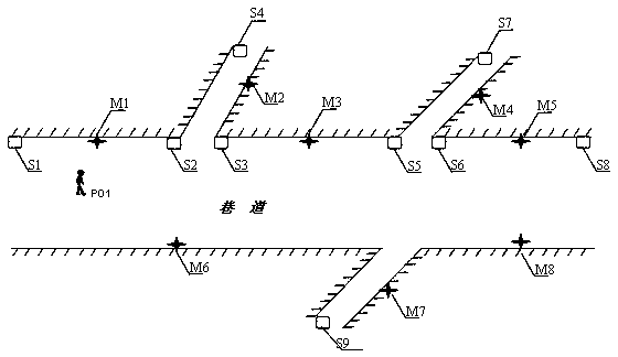
[0029] see figure 1 , an underground positioning method combining geomagnetism and RFID radio frequency, which is carried out according to the following steps:

[0030] Step 1: Install RFID radio frequency identification cards and artificial magnetic markers at specific positions in the roadway, underground personnel carry positioning devices, and assemble radio frequency collectors and geomagnetic measurement sensors in the positioning devices, specifically:

[0031] ①Install radio frequency transmitting devices at the two ends of a roadway and at the inflection point of the roadway. Each radio frequency transmitting device is installed with an RFID radio frequency identification card inside. In the radio frequency identification database, the database structure is the radi...


PUM


Abstract

The invention discloses a geomagnetism and RFID (radiofrequency identification) radiofrequency combined underground positioning method. The geomagnetism and RFID radiofrequency combined underground positioning method includes steps of mounting RFID cards and artificial magnetic marks on roadways and assembling information collectors and geomagnetic sensors in underground staff positioning devices; drawing underground roadway diagrams, underground geomagnetism distribution diagrams and roadway radiofrequency identification card distribution diagrams; allowing underground staffs to carry the underground staff positioning devices; transmitting wireless signals with serial numbers by the RFID cards in the roadways, receiving the wireless signals by the underground staff positioning devices, recording and judging the strength of the wireless signals, carrying out rough location matching computation and displaying current locations of the underground staffs; overlaying underground natural geomagnetic fields with the artificial magnetic marks to form underground magnetic fields, receiving magnetic field data by the aid of the geomagnetic sensors of the underground staff positioning devices, recording the magnetic field data, carrying out accurate location matching computation and displaying current accurate locations of the underground staffs. The geomagnetism and RFID radiofrequency combined underground positioning method has the advantages that the underground staffs can be positioned and navigated by the aid of the geomagnetism and RFID radiofrequency combined underground positioning method under underground power supply breakdown or signal interruption conditions, and the geomagnetism and RFID radiofrequency combined underground positioning method is high in positioning precision.

Description

technical field [0001] The invention relates to the technical field of underground positioning, in particular to an underground positioning method combining geomagnetism and RFID radio frequency. Background technique [0002] Underground positioning and emergency avoidance technology is the key guarantee for underground safety production and supervision and management. When a dangerous accident occurs in a mine, underground personnel or rescuers need to use positioning technology to accurately and quickly grasp the current exact location and obtain The distribution information of the surrounding avoidance settings can analyze the optimal path of escape or rescue, and avoid the impact of disasters, so as to ensure the safety of life during the avoidance or rescue process. [0003] The principle of the existing downhole positioning method is: install radio frequency positioning cards or wireless positioning terminals on the underground workers, and install radio frequency info...

Claims


Application Information

Patent Timeline
Patent Type & Authority Patents(China)
IPC IPC(8): E21F17/18G01C21/08H04W64/00
CPCE21F17/18G01C21/08H04W64/00
Inventor 汪金花郭立稳张亚静白洋李卫强
Owner NORTH CHINA UNIVERSITY OF SCIENCE AND TECHNOLOGY
Features
  • R&D
  • Intellectual Property
  • Life Sciences
  • Materials
  • Tech Scout
  • Unparalleled Data Quality
  • Higher Quality Content
  • 60% Fewer Hallucinations
Learn More