A blind-guiding method and system based on satellite precise positioning technology

A precise positioning and blind-guiding system technology, which is applied in the field of satellite precise positioning and navigation, can solve the problems of not taking into account the detection of low obstacles and high roadside obstacles at the same time, the map is not suitable for guiding the blind, and the error is large.

Inactive Publication Date: 2019-04-12
BEIJING NORMAL UNIV ZHUHAI
View PDF4 Cites 0 Cited by
  • Summary
  • Abstract
  • Description
  • Claims
  • Application Information

AI Technical Summary

Problems solved by technology

[0004] 2. Electronic maps mainly developed for car navigation applications are used in the current blind guide technology. This type of map focuses on driving routes and some important places, but the places or routes to be walked by blind people may not be marked, or Although marked, but the error is too large
Therefore, this type of map is not suitable for guiding the blind
[0005] 3. In the current ultrasonic blind guide, the detection of low obstacles on the road and high obstacles on the roadside cannot be considered at the same time

Method used


Image

  • A blind-guiding method and system based on satellite precise positioning technology
  • A blind-guiding method and system based on satellite precise positioning technology
  • A blind-guiding method and system based on satellite precise positioning technology

Examples


Embodiment 1

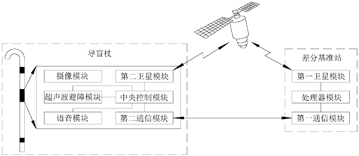
[0051] Such as figure 1 , the blind guide system based on satellite precise positioning technology in this embodiment includes satellites, differential reference stations and blind guide sticks; the satellite, differential reference stations and blind guide sticks exchange data with each other in a wireless manner.

[0052] The differential reference station calculates the current pseudo-position or pseudo-range of the differential reference station according to the received satellite data, and corrects the current pseudo-position or pseudo-range of the differential reference station, and compares the obtained correction value with the previous correction value Compare and output the current correction value whose difference is greater than the predetermined threshold to the blind guide stick, otherwise it will not be processed.

[0053] The blind guide stick corrects the current pseudo-position or pseudo-range of the blind guide stick according to the received satellite data ...


PUM


Abstract

The invention provides a blind guiding system based on a satellite precision positioning technology. The blind guiding system comprises a satellite, a differential reference station and a blind guiding stick. The satellite, the differential reference station and the blind guiding stick exchange data in a wireless mode. The differential reference station resolves a current pseudo position or current pseudo range of the differential reference station according to received satellite data, corrects the current pseudo position or current pseudo range of the differential reference station, compares a newly-obtained correction value with a last correction value, and outputs a current correction value that a difference is larger than a preset threshold to the blind guiding stick. The blind guiding stick corrects a current pseudo position or current pseudo range of the blind guiding stick according to received satellite data and the current correction value of the differential reference station so as to obtain accurate position coordinates of the blind guiding stick, compares accurate position coordinates of the blind guiding stick with route coordinates obtained in route establishment, and sending a reminder to the blind or searching help for the blind according to a comparison result, or a detected obstacle type, or an identified traffic signal, or a current environment.

Description

【Technical field】 [0001] The invention relates to the field of satellite precise positioning and navigation, in particular to a precise positioning and navigation system serving the blind. 【Background technique】 [0002] Because blind people cannot see, it is extremely inconvenient to travel. Unless they are accompanied by family members, it is difficult for them to walk an inch. A well-trained guide dog can also lead the blind to travel without the company of family members, but it is not easy to train a guide dog, and only a very small number of blind people can own it. Therefore, people have been trying to find other blind-guiding methods or technologies that can replace guide dogs. Among them, GPS blind-guiding and ultrasonic blind-guiding technologies have been studied the most, and many related patents have also been produced. However, in the current GPS and ultrasonic blind guiding technology, there are the following problems or deficiencies: [0003] 1. The positi...

Claims


Application Information

Patent Timeline
Patent Type & Authority Patents(China)
IPC IPC(8): G01S19/41G01S15/93
CPCG01S15/93G01S19/41
Inventor 王光学闫丽华
Owner BEIJING NORMAL UNIV ZHUHAI
Why Eureka
Try Eureka