Method and system for forecasting degree of influence of ponding on areas in city
A technology of influence degree and inner area, which is applied in the field of predicting the influence degree of stagnant water on the inner area of the city, which can solve the problems such as the inability to accurately predict the influence degree of stagnant water, and achieve the effect of improving the accuracy.
- Summary
- Abstract
- Description
- Claims
- Application Information
AI Technical Summary
Problems solved by technology
Method used
Image
Examples
Embodiment 1
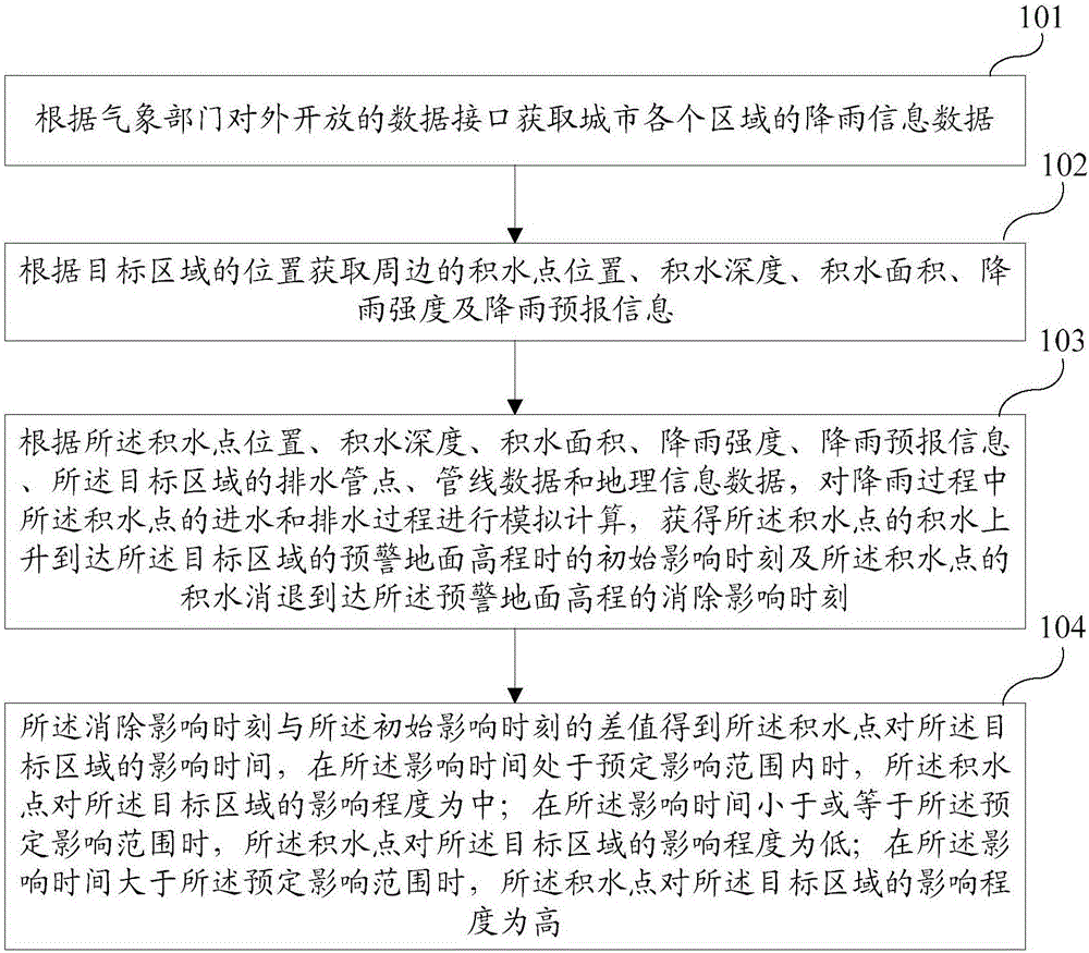
[0050] Such as figure 1 As shown, it is a schematic flow chart of the method for predicting the degree of impact of stagnant water on urban areas described in this embodiment. The method described in this embodiment solves the technical problem that the degree of impact of stagnant water on urban areas cannot be accurately predicted in the prior art. . The method for predicting the degree of impact of stagnant water on urban areas described in this embodiment includes the following steps:
[0051] Step 101 , according to the data interface (API) opened to the public by the meteorological department, the rainfall information data of each area of the city is obtained.
[0052] Preferably, this program can be set to analyze and obtain the rainfall information data of the target area in the city from the API of the meteorological department, and obtain the current rainfall intensity in the target area, and the current rainfall intensity in the target area reaches or exceeds the...
Embodiment 2
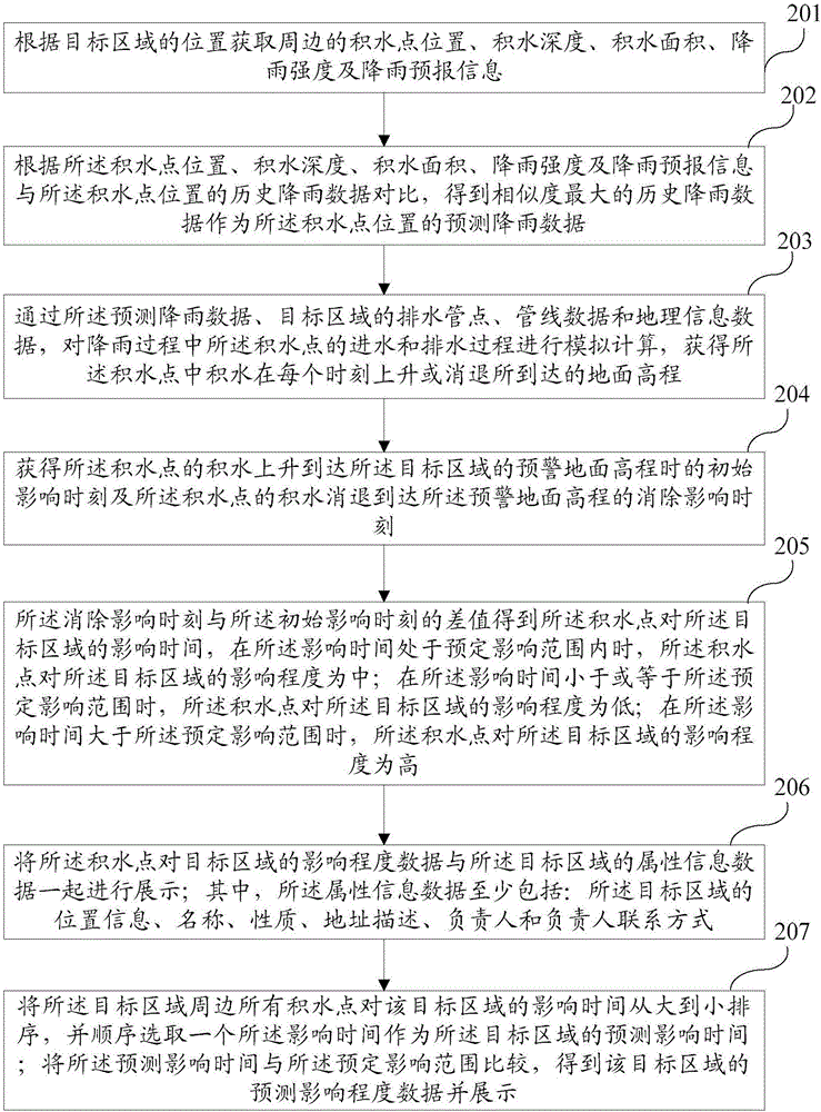
[0070] Such as figure 2 As shown, it is a schematic flow chart of the method for predicting the degree of impact of stagnant water on urban areas described in this embodiment. On the basis of Embodiment 1, this embodiment describes the water intake and The specific content of the simulation calculation of the drainage process. The method for predicting the degree of impact of stagnant water on urban areas described in this embodiment includes the following steps:
[0071] Step 201 , according to the location of the target area, obtain the surrounding water accumulation point location, water accumulation depth, water accumulation area, rainfall intensity and rainfall forecast information.
[0072] Step 202: According to the location of the accumulated water point, the depth of the accumulated water, the area of the accumulated water, the intensity of rainfall, and the rainfall forecast information, and the historical rainfall data at the location of the accumulated water po...
Embodiment 3
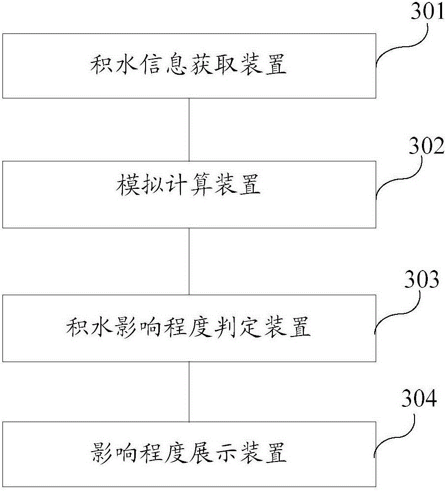
[0098] Such as image 3 As shown, it is a schematic structural diagram of the system for predicting the degree of impact of stagnant water on urban areas described in this embodiment. The system described in this embodiment is used to implement the method for predicting the degree of impact of stagnant water on urban areas described in the above embodiments. . The system described in this embodiment includes: a water accumulation information acquisition device 301 , a simulation calculation device 302 and a water accumulation degree determination device 303 .
[0099] Wherein, the accumulating water information acquisition device 301 is connected with the analog computing device 302 and is used to obtain the surrounding water accumulating point position, accumulating water depth, accumulating area, rainfall intensity and rainfall forecast information according to the position of the target area. device.
[0100] The simulation calculation device 302 is connected with the wat...
PUM
 Abstract
Description
Claims
Application Information
 - R&D
- Intellectual Property
- Life Sciences
- Materials
- Tech Scout
- Unparalleled Data Quality
- Higher Quality Content
- 60% Fewer Hallucinations
Browse by: Latest US Patents, China's latest patents, Technical Efficacy Thesaurus, Application Domain, Technology Topic, Popular Technical Reports.
© 2025 PatSnap. All rights reserved.Legal|Privacy policy|Modern Slavery Act Transparency Statement|Sitemap|About US| Contact US: help@patsnap.com


