A weighting method for gnss satellite observations based on joint altitude and user ranging errors

A technology of ranging error and satellite observation, applied in satellite radio beacon positioning systems, measurement devices, radio wave measurement systems, etc., can solve the problem of not taking into account the differences in satellite orbit and clock error accuracy, and achieve a reasonable weighting strategy , Improve the effect of positioning accuracy

Inactive Publication Date: 2019-05-10
WUHAN UNIV
View PDF3 Cites 0 Cited by
  • Summary
  • Abstract
  • Description
  • Claims
  • Application Information

AI Technical Summary

Problems solved by technology

The current equal-precision weighting method, altitude angle weighting method, and signal-to-noise ratio weighting method do not take into account the accuracy differences between satellite orbits and clock errors. Therefore, in multi-orbit and multi-GNSS system precision positioning, how to It is an urgent problem to be solved to improve the positioning accuracy by setting the weight of the observation value to the ground

Method used


Image

  • A weighting method for gnss satellite observations based on joint altitude and user ranging errors
  • A weighting method for gnss satellite observations based on joint altitude and user ranging errors
  • A weighting method for gnss satellite observations based on joint altitude and user ranging errors

Examples


Embodiment Construction

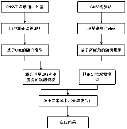
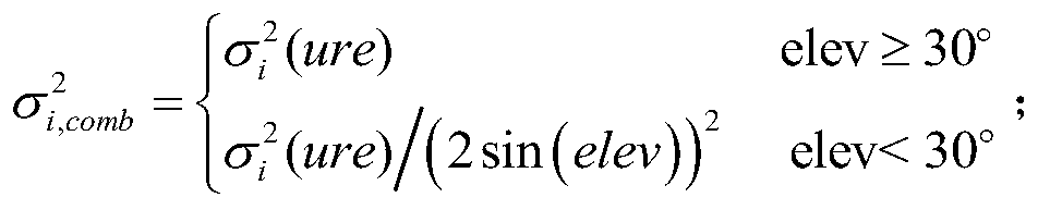
[0026] The invention proposes a method for determining the weight of GNSS observation values ​​in combination with altitude angle and user ranging error. See attached figure 1 , the basic process of the present invention is: on the one hand, considering errors such as troposphere, ionosphere and other atmospheric delays and multipath effects, using traditional methods to determine the stochastic model of observations based on elevation angle; on the other hand, considering satellite orbits and clocks Based on the influence of difference error on precise positioning, a new URE-based observation stochastic model is constructed; combined with the observation stochastic model based on elevation angle and URE, the weight of GNSS observations is determined.

[0027] The specific implementation process includes the following steps:

[0028] Step 1, according to the GNSS satellite orbit and clock error data, use the segmentation method to determine the user ranging error URE of each ...


PUM


Abstract

The present invention discloses a GNSS satellite observed value weighting method jointing the elevating angles and the URE. The method comprises the steps of S1 determining the URE of each GNSS satellite in a GNSS; S2 based on the URE, constructing an observed value random model; S3 weighting the GNSS satellite observed values by combining the observed value random model based on the elevating angles and the URE. According to the present invention, by considering the influence of the troposphere and ionized layer delay and the multipath errors in the GNSS measurement on the observed values and the influence of the satellite orbits and the satellite clock errors on the precision positioning, the weighting method jointing the satellite elevating angles and the URE is constructed, is more reasonable in weighting strategy, and accords with the GNSS precision positioning theory better.

Description

technical field [0001] The invention belongs to the technical field of GNSS high-precision positioning of the global satellite navigation system, and in particular relates to a method for determining the weight of GNSS satellite observation values ​​combined with altitude angle and user ranging error (URE, User Range Error). Background technique [0002] The global satellite navigation system GNSS (GPS in the United States, GLONASS in Russia, Galileo in the European Union, BDS in China, etc.) has become an important space infrastructure for obtaining high-precision navigation and positioning information in a timely manner. GEO / IGSO / MEO multi-orbit coexistence and multi-orbit GNSS system joint data processing is one of the important features and advantages of the development of satellite navigation system positioning technology. my country's Beidou satellite navigation system BDS completed the second step of construction (5GEO+5IGSO+4MEO constellation) at the end of December ...

Claims


Application Information

Patent Timeline
Patent Type & Authority Patents(China)
IPC IPC(8): G01S19/45
CPCG01S19/45
Inventor 耿涛赵齐乐谢新
Owner WUHAN UNIV
Why Eureka
Try Eureka