Desert riparian forest spatial distribution obtaining method based on GIS buffer area analysis

A buffer analysis and acquisition method technology, which is applied in the field of remote sensing monitoring of vegetation in arid areas, can solve the problems of lack of gradient spatial distribution information extraction and analysis methods, and achieve the effect of convenient and accurate data acquisition, high efficiency, and low manpower and material resources consumption

Active Publication Date: 2017-09-08
HOHAI UNIV
View PDF4 Cites 23 Cited by
  • Summary
  • Abstract
  • Description
  • Claims
  • Application Information

AI Technical Summary

Problems solved by technology

However, the research is limited to the data of some monitoring points. On a large scale, there is little analysis of the continuous gradient spatial distribution of desert riparian forests and the determination of the scope of river water influence (Bai Yuan, Xu Hailiang, Liu Xinhua, et al. Spatial distribution and ecological protection of riparian forests [J]. Journal of Natural Resources, 2013, 28(5): 776-785.), and there is also a lack of corresponding efficient and convenient gradient spatial distribution information extraction and analysis methods

Method used


Image

  • Desert riparian forest spatial distribution obtaining method based on GIS buffer area analysis
  • Desert riparian forest spatial distribution obtaining method based on GIS buffer area analysis
  • Desert riparian forest spatial distribution obtaining method based on GIS buffer area analysis

Examples


Embodiment Construction

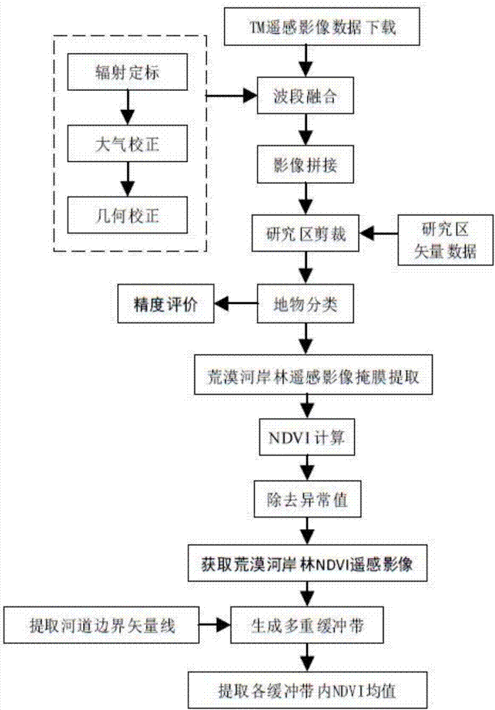
[0033] Specific embodiments of the present invention will be described in detail below in conjunction with the accompanying drawings.

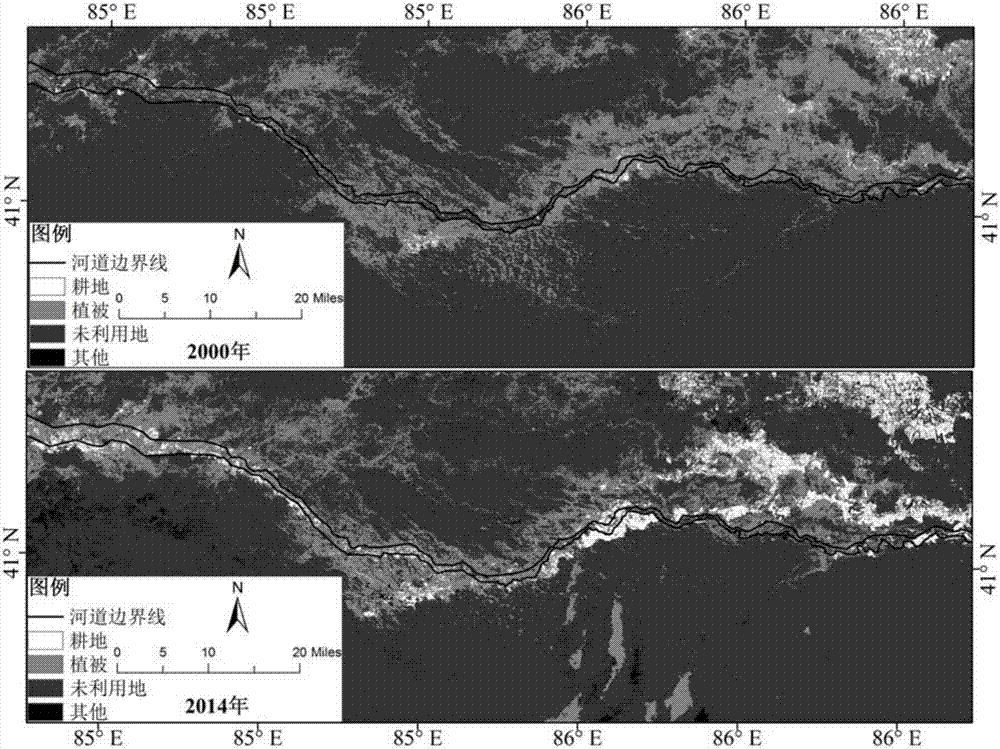
[0034] The banks of the Tarim River have the world's largest and most densely distributed desert riparian forest plant community with Populus euphratica forest as the main body. Its abundant output provides a suitable habitat for biodiversity and organic food for aquatic organisms. It has a strong ecological function and brings vitality to the desolate inland basin. However, the population growth in the source area and the unreasonable development and waste of water resources have affected the desert riparian forest ecosystem of the main stream of the Tarim River to a certain extent. Along with the growth of time, in order to study the spatial gradient distribution structure change of the vertical channel of the desert riparian forest in the mainstream of the Tarim River, the middle reaches of the Tarim River are taken as the research object b...


PUM


Abstract

The invention discloses a desert riparian forest spatial distribution obtaining method based on GIS buffer area analysis, wherein the method belongs to the field of drought area vegetation remote sensing technology. The method comprises the following steps of a first step, downloading a TM remote sensing image of a location with a drought area river, performing image preprocessing, remote sensing interpretation and NDVI calculation on the remote sensing image, and obtaining NDVI remote sensing data of the desert riparian forest; a second step, extracting a riverbank boundary vector line, and performing unified registering and correction on the remote sensing image in a GIS platform; a third step, generating a riverway peripheral multiple-buffer-area vector picture according to a research requirement; and a fourth step, overlapping the multiple-buffer-area vector picture and the NDVI remote sensing data of the desert riparian forest, extracting an NDVI mean value in each buffer area, using a vertical riverawy distance as an independent variable and using the NDVI mean value as a dependent variable, and performing desert riparian forest spatial distribution structure analysis by means of curve fitting. The desert riparian forest spatial distribution obtaining method supplies a beneficial reference for determining continuous gradient distribution of the desert riparian forest and the protecting range thereof.

Description

technical field [0001] The invention relates to the technical field of remote sensing monitoring of vegetation in arid areas, in particular to a method for obtaining spatial gradient distribution of desert riparian forests based on GIS (Geographic Information System) buffer analysis. Background technique [0002] Desert is an important geographical landscape in the western arid region. It forms a special coupling relationship with mountains and oases in the arid region, and constitutes the core content of the mountain basin system in the western arid region. Among them, the desert riparian forest ecosystem that lives on water is the natural protection system of the oasis system, which is of great significance to the coordinated development of deserts, mountains and oases. Desert riparian forest is a unique landscape of arid inland river basins, also known as dugayilin. It is concentrated along the banks of inland river basins in arid areas. It mainly depends on groundwater f...

Claims


Application Information

Patent Timeline
Patent Type & Authority Applications(China)
IPC IPC(8): G06K9/00G06K9/62G06F17/30G06T7/30G06T11/20
CPCG06F16/29G06T7/30G06T11/203G06T2207/30188G06T2207/10032G06V20/182G06V20/188G06F18/24
Inventor 黄显峰刘娇方国华陈颖钦刘展志唐肖阳
Owner HOHAI UNIV
Why Eureka
Try Eureka