Method and system for configuring geographic information map based on local area network

A configuration method and local area network technology, applied in the field of energy management, can solve the problems that the energy management system cannot effectively manage energy, cannot browse map products, etc.

Active Publication Date: 2020-05-19
深圳市康必达中创科技有限公司
View PDF12 Cites 0 Cited by
  • Summary
  • Abstract
  • Description
  • Claims
  • Application Information

AI Technical Summary

Problems solved by technology

[0006] The technical problem to be solved by the present invention is to provide a geographical information map configuration method and system based on a local area network, aiming to solve the problem that the map products cannot be browsed due to network restrictions, and the energy management system cannot use the geographic information map display function to The problem of efficient energy management

Method used


Image

  • Method and system for configuring geographic information map based on local area network
  • Method and system for configuring geographic information map based on local area network
  • Method and system for configuring geographic information map based on local area network

Examples


Embodiment Construction

[0080] In order to make the object, technical solution and advantages of the present invention clearer, the present invention will be further described in detail below in conjunction with the accompanying drawings and embodiments. It should be understood that the specific embodiments described here are only used to explain the present invention, not to limit the present invention.

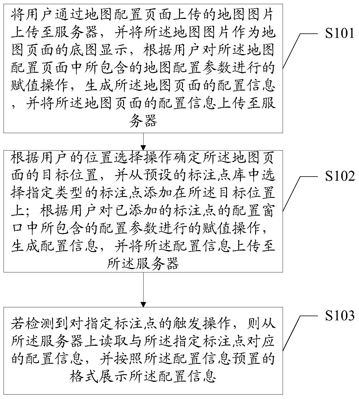
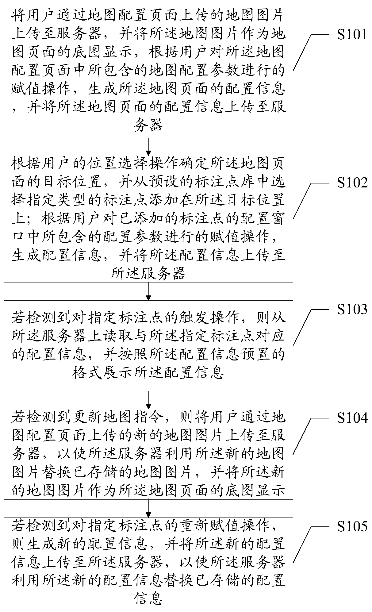
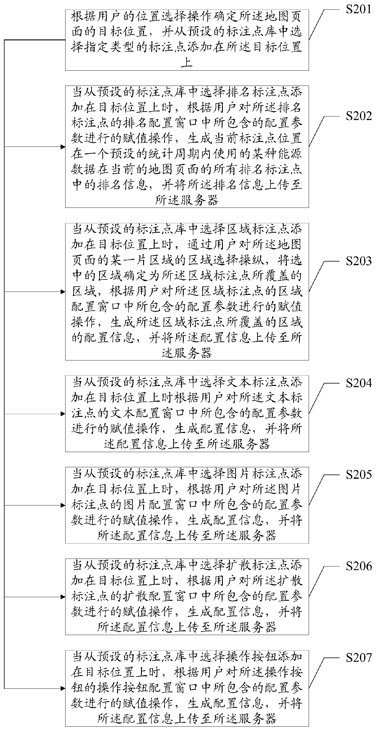
[0081] As a first embodiment of the present invention, such as figure 1 As shown, it is a flowchart of a geographical information map configuration method based on a local area network provided by the first embodiment of the present invention. The geographical information map configuration method based on a local area network is mainly used in a local area network. The method includes:

[0082] Step S101: Upload the map picture uploaded by the user through the map configuration page to the server, and display the map picture as the base map of the map page, and generate The configuration informati...


PUM


Abstract

The present invention belongs to the technical field of energy management and provides a geographical information map configuration method and system based on a local area network. A user can customize and configure a geographical information map system in a local area network without connecting to a third-party map product, and all users in the local area network can view map information in the configured geographical information map system, so that the problem that browsing the existing map product is restricted by the network is solved. The method and system provided by the present invention are mainly applied to the field of energy management. The configuration parameters of the annotation points are mainly designed according to the demand of the energy service, and the user assigns values to the configuration parameters according to the actual energy service condition, and each annotation point on a map page can directly present related energy data, so as for energy management personnel to learn and analyze the energy condition of each annotation point, so that the problem that the existing energy management system cannot effectively manage energy by using the geographical information map display function is solved.

Description

technical field [0001] The invention belongs to the technical field of energy management, and in particular relates to a local area network-based geographic information map configuration method and system. Background technique [0002] The energy management system is an important part of the enterprise information system. The energy management system is mainly used to collect, process, analyze and process energy data. [0003] Through the geographic information map display function, the energy consumption in each place can be visually displayed. Therefore, the geographic information map display function is a function point that the energy management systems of major enterprises need to have. [0004] At present, the map products of large map service providers such as Baidu Map, Gaode Map, and Google Map can realize geographic information maps through secondary development (that is, by docking or embedding the above map products in the energy management system). Showcase fu...

Claims


Application Information

Patent Timeline
Patent Type & Authority Patents(China)
IPC IPC(8): G06F16/29G06Q50/06
CPCG06F16/29G06Q50/06Y04S50/16
Inventor 魏洪飞陈林王辉
Owner 深圳市康必达中创科技有限公司
Why Eureka
Try Eureka