GPS-based determination method and determination system for in-out regions

A regional and intra-regional technology, applied in the field of GPS positioning, can solve problems such as worry, trouble, walking, etc., and achieve the effect of improving the accuracy of judgment

Active Publication Date: 2018-04-06
XIAMEN YAXON NETWORKS CO LTD
View PDF14 Cites 8 Cited by
  • Summary
  • Abstract
  • Description
  • Claims
  • Application Information

AI Technical Summary

Problems solved by technology

In this way, the positioning system may report in the school for a while, and report outside the school for a while, but actually walk on the small road beside the school wall
Repeated alarm prompts will cause unnecessary worries for the inspectors who master the positioning terminal, and at the same time bring trouble

Method used


Image

  • GPS-based determination method and determination system for in-out regions
  • GPS-based determination method and determination system for in-out regions
  • GPS-based determination method and determination system for in-out regions

Examples


Embodiment 1

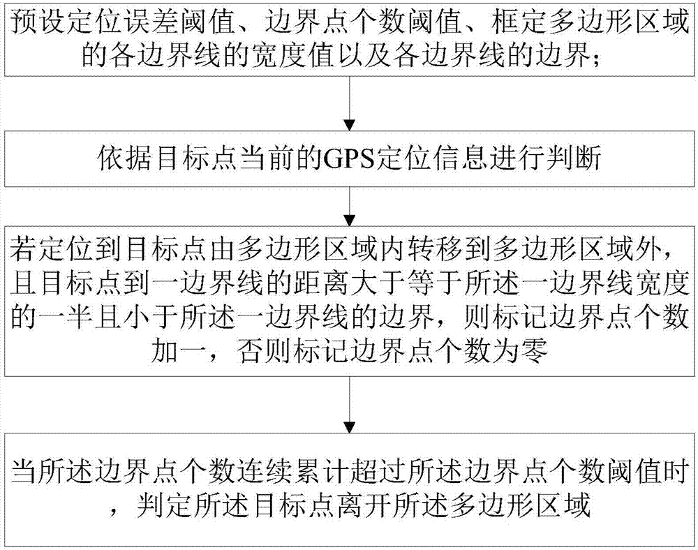
[0068] Please refer to figure 1 , this embodiment provides a GPS-based method for judging the entry and exit of an area, which is suitable for a system that uses GPS for target point positioning, and can accurately determine that a target point enters or leaves an area, thereby significantly improving the accuracy of GPS positioning.

[0069] In the map data, the delineated boundary line has a certain width, and the size of the boundary area can be determined by the width and length of the boundary line. Mapping the map data to the actual geographic location, the boundary area cannot completely coincide with the road or terrain, and there are certain errors in GPS positioning itself. When the target point moves near the boundary area, it often does not enter the boundary area, or repeatedly enters and exits the boundary area, but in fact the target point does not really enter the corresponding area, which will lead to inaccurate positioning of the target point.

[0070] In re...

Embodiment 2

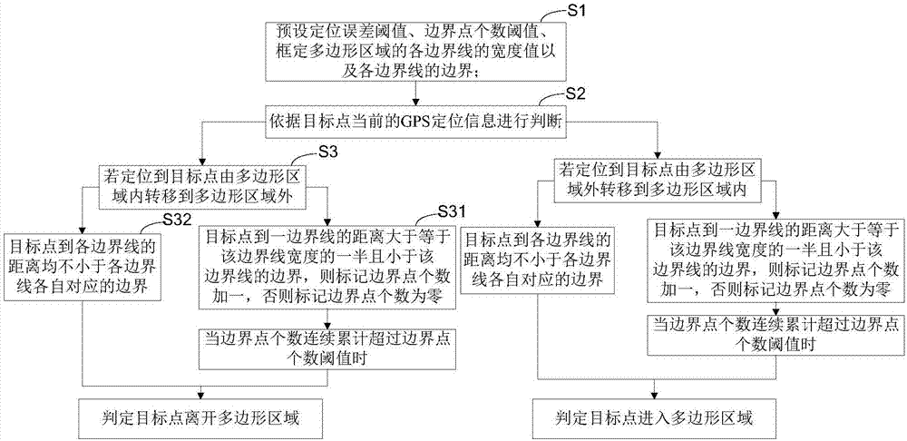
[0080] see figure 2 , on the basis of Embodiment 1, this embodiment provides a method for accurately determining whether a target point enters a preset polygonal area based on the same technical concept. The same as the first embodiment will not be repeated, the difference is:

[0081] In step S2, if the target point is located and shifted from outside the polygonal area to within the polygonal area, then execute S3;

[0082] In step S31, it is determined that the target point enters the polygonal area when the cumulative number of the boundary points exceeds the threshold of the number of boundary points.

[0083] In S32, if the distance from the target point to each boundary line is not less than the boundary corresponding to each boundary line, it is also determined that the target point enters the polygonal area.

Embodiment 3

[0085] On the basis of the first and second embodiments, this embodiment provides a GPS-based judgment method for entering and exiting an area. The judging method can be realized based on a GPS positioning terminal and a configuration tool, and the GPS positioning terminal includes a positioning module, a timer, a communication module and a storage module; the GPS positioning terminal can be a mobile phone or other independent smart devices, and can be provided with positioning monitoring The elderly and children in need wear it with them to control their itinerary at any time and ensure their safety; they can also be worn by the user themselves to guide them during the journey.

[0086] The storage unit is used to save the position status and polygon area information of the GPS positioning terminal;

[0087] Set the positioning error threshold, the threshold of the number of boundary points, the latitude and longitude of the polygon area, and the width of each side of the pol...


PUM


Abstract

The invention relates to a GPS-based determination method and determination system for in-out regions. The method comprises: a positioning error threshold and a threshold of the number of boundary points are preset and width values of all boundary lines and boundaries of all boundary lines of a polygonal region are determined, wherein the boundaries are sums of half of the width values of the boundary lines and the positioning error threshold; determination is carried out based on current GPS positioning information of a target point; if the target point is located to be transferred from the inside of the polygonal region to outside of the polygonal region and the distance between the target point and one boundary line is larger than or equal to the half of the width of the boundary line and is smaller than the boundary of the boundary line, the number of the boundary points is marked to be one pulse one and otherwise, the number of the boundary points is marked to be zero; and when the number of the boundary points is accumulated continuously to exceed a boundary point number threshold, the target point is determined to leave the polygonal region. Therefore, a phenomenon that frequent false reporting of in-out regions occurs when the target is in the boundary region is avoided. The accuracy of GPS positioning is improved obviously and the user experience is optimized substantially.

Description

technical field [0001] The invention relates to the field of GPS positioning, in particular to a GPS-based judgment method for entering and exiting an area and a system thereof. Background technique [0002] With the existing GPS positioning technology, when the positioning terminal is at the boundary of a polygonal area, due to certain errors in GPS positioning, there will be frequent false alarms of entering and exiting the area. Assume that the area covered by the school is set as the polygon area to be judged, and the students walk on the path beside the school wall with the GPS positioning terminal. Since the GPS positioning itself has a certain error, and the error is not in a fixed direction, it has a certain degree of randomness. It is possible that the positioning data will fall within the school area for a while, and fall outside the school area for a while. As a result, the positioning system may report in the school for a while, and report outside the school for...

Claims


Application Information

Patent Timeline
Patent Type & Authority Applications(China)
IPC IPC(8): G01S19/42
CPCG01S19/42
Inventor 韩震华许水燕解玉芳张屿
Owner XIAMEN YAXON NETWORKS CO LTD
Why Eureka
Try Eureka