
A real-time routing planning method for urban areas based on vehicle-road coordination

A technology of urban area and vehicle-road coordination, which is applied in the field of route planning, intelligent transportation/vehicle-road coordination technology, and can solve problems such as deviation, not taking into account the different time spent by vehicles, insufficient calculation accuracy and real-time performance, etc.

Active Publication Date: 2020-01-10
NORTH CHINA UNIVERSITY OF TECHNOLOGY
View PDF4 Cites 0 Cited by
  • Summary
  • Abstract
  • Description
  • Claims
  • Application Information

AI Technical Summary

Problems solved by technology

[0018] (3) At present, the data used in the research of path planning system is mainly obtained indirectly based on sources such as mobile trajectory, mobile phone signaling and detectors, and there is a certain deviation from the real scene, resulting in some shortcomings in calculation accuracy and real-time performance
In the traditional method, the method of calculating a road resistance weight value for each road section does not take into account the fact that the vehicle takes different time to turn under the influence of the light control signal. In urban roads, the road resistance change caused by signal control is very obvious

Method used


Image

  • A real-time routing planning method for urban areas based on vehicle-road coordination
  • A real-time routing planning method for urban areas based on vehicle-road coordination
  • A real-time routing planning method for urban areas based on vehicle-road coordination

Examples


Embodiment Construction

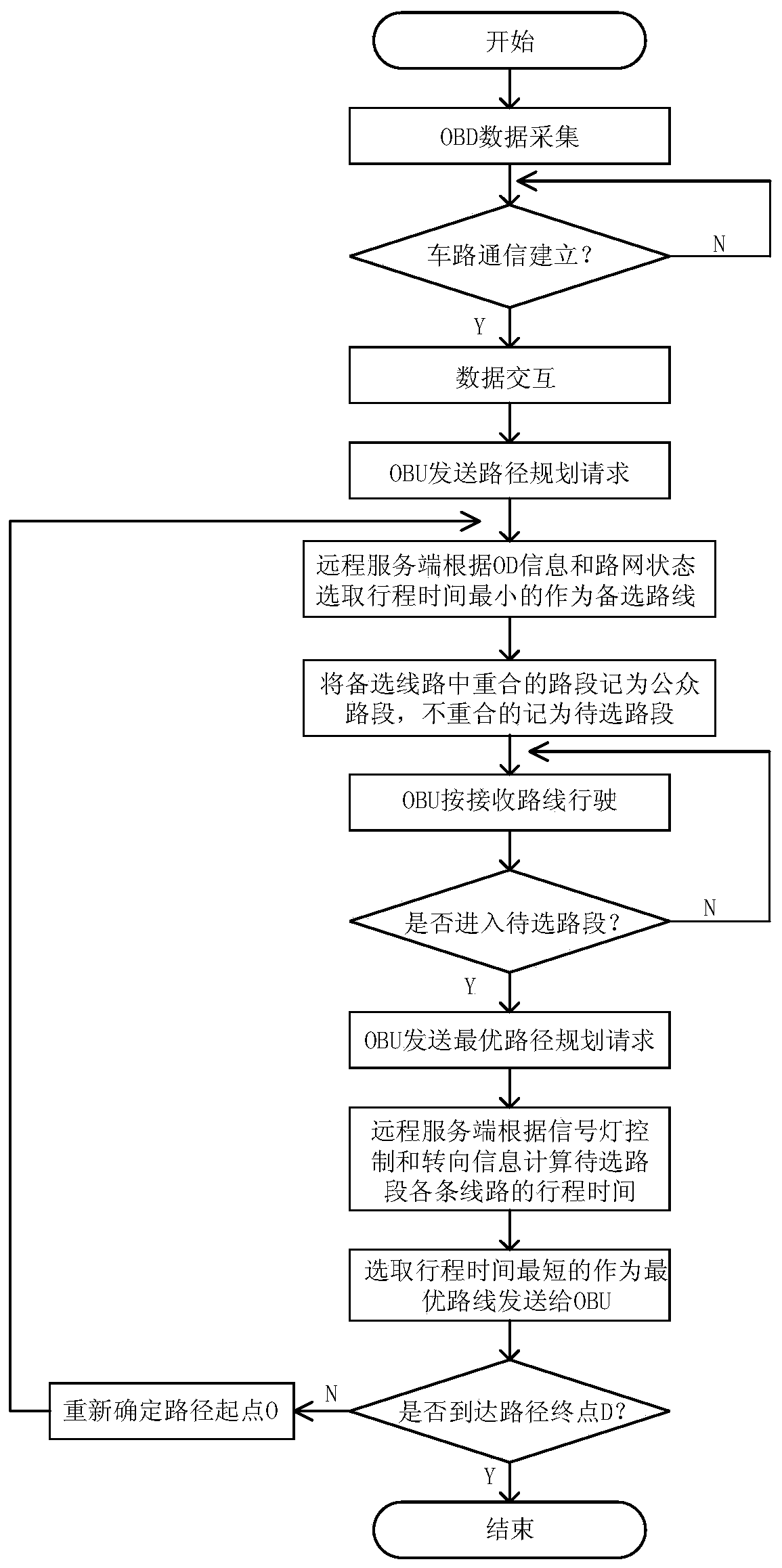
[0054] (1) A real-time path planning method considering the influence of light control under the vehicle-road coordination system

[0055] The core idea of ​​this method is to use the roadside signal control data provided by the vehicle-road coordination technology and the communication means of the V2X network to provide a refined comparison considering signal control for multiple routes with similar travel times provided by the global algorithm. , and gradually get the optimal driving route for the whole journey. Method flow chart as figure 1 shown. The specific implementation steps of this method are as follows:

[0056] Step 1: Establish V2X network communication between the intelligent vehicle information terminal (On board Unit, OBU) installed on the vehicle and the roadside terminal (RoadSide Unit, RSU).

[0057] Step 2: The vehicle terminal reports the required statistical data to the roadside terminal according to the vehicle bus and sensor information, and sends a...


PUM


Abstract

The invention provides an urban area path real-time planning method based on cooperation between vehicles and roads. According to the dispersing process of queuing vehicles, the urban area path real-time planning method based on cooperation between vehicles and roads divides the road conditions into a parking situation, a no-parking deceleration situation and a uniform driving situation, and calculates a road resistance value according to different situations. The urban area path real-time planning method based on cooperation between vehicles and roads fully utilizes the high-efficiency information interaction technological advantage brought by the advanced vehicle-road cooperation technology, proposes a calculation method considering the travel time of a vehicle on a road section and an intersection under the influence of traffic signal control so as to provide a phased urban area optimal path optimization method for the traditional path method, and can provide technical support and theoretical basis for solving the path problem in the vehicle-road cooperation system.

Description

technical field [0001] The invention belongs to the field of intelligent transportation / vehicle-road coordination technology and path planning, and specifically relates to a vehicle-road coordination-based system that takes intersection traffic signal control and path steering information as influencing factors and further optimizes the results obtained by traditional path planning systems. Real-time planning and decision-making method for regional routes. Background technique [0002] With the increase of the number of automobiles in our country year by year, while the popularization of vehicles brings convenience to people's travel, due to the relatively slow construction of supporting road facilities, traffic congestion occurs frequently. At present, floating vehicle technology or fixed traffic detector technology are commonly used as real-time traffic data collection and analysis methods, but the types of real-time traffic data that can be provided by a single data colle...

Claims


Application Information

Patent Timeline
Patent Type & Authority Patents(China)
IPC IPC(8): G08G1/0968G08G1/01
CPCG08G1/0116G08G1/012G08G1/0968
Inventor 王庞伟邓辉王力蒋依伦张名芳
Owner NORTH CHINA UNIVERSITY OF TECHNOLOGY
Learn More