A road network layering method based on road planning structure and visual salience

A road network and road planning technology, applied in the CAD network environment, geometric CAD, special data processing applications, etc., can solve the problems that roads have no characteristics and are difficult to cause.

Active Publication Date: 2021-03-30
CHINA UNIV OF GEOSCIENCES (WUHAN)
View PDF3 Cites 0 Cited by
  • Summary
  • Abstract
  • Description
  • Claims
  • Application Information

AI Technical Summary

Problems solved by technology

This measurement only considers the characteristics of the road itself, but ignores the comparison between the road and the surrounding environment, which may cause the roads defined as salient to be difficult to attract people's attention due to their lack of features, such as grids with high betweenness centrality shaped road

Method used


Image

  • A road network layering method based on road planning structure and visual salience
  • A road network layering method based on road planning structure and visual salience
  • A road network layering method based on road planning structure and visual salience

Examples


Embodiment Construction

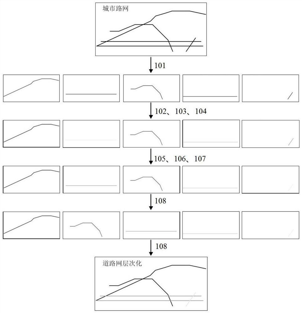
[0046] In order to make the purpose, technical solution and advantages of the present invention clearer, the embodiments of the present invention will be further described below in conjunction with the accompanying drawings.

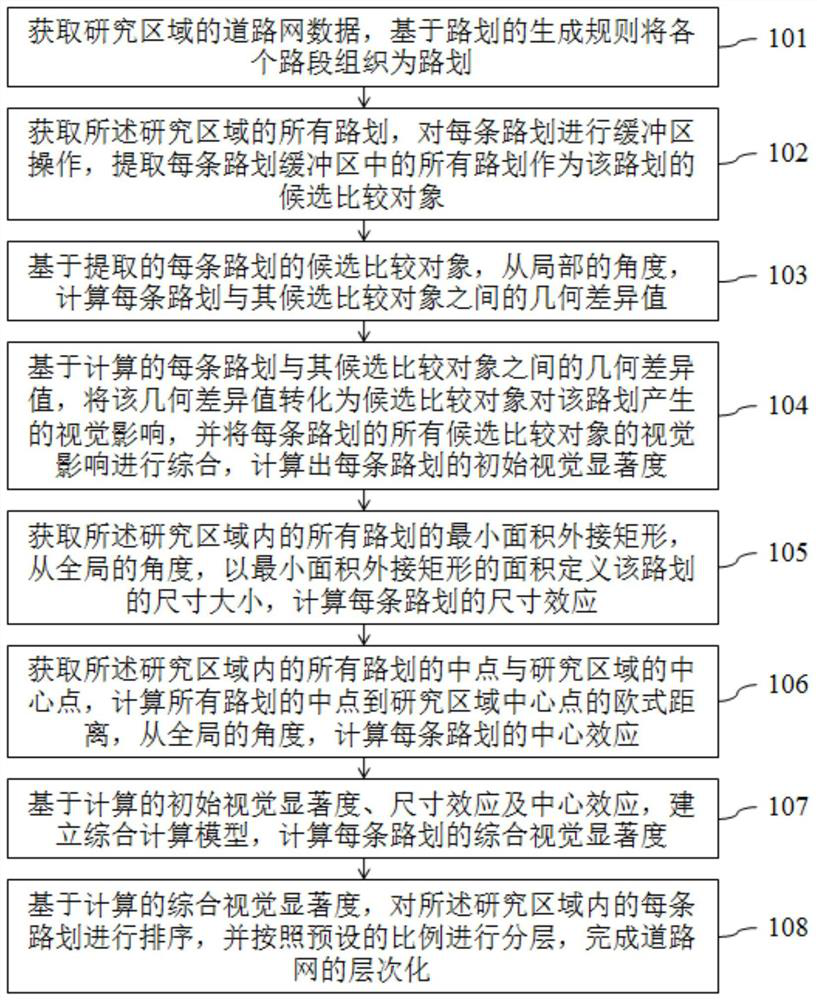
[0047] Such as Figure 1-2 As shown, the embodiment of the present invention provides a road network layering method based on the road planning structure and visual salience, which is used for the layering of the road network, including the following steps:

[0048] Step 101: Obtain the road network data of the research area, organize each road segment into road plans based on the generation rules of road plans, and use each road plan as a perception unit, denoted as T i (i=1,2,3...N, N is a positive integer greater than or equal to 1, and N is the total number of perception units in the research area);

[0049] Step 102: Based on all roads in the research area acquired in step 101, draw T for each road i Perform buffer operation, extract all the roads...


PUM


Abstract

The invention discloses a road network layering method based on a road division structure and visual saliency, which comprises the following steps of firstly, acquiring a perception unit which can represent road division with road visual continuity as a basis so as to capture perception characteristics of typical visual neurons; secondly, performing buffer operation on each road sign, and calculating the relative geometric difference between the road sign and the peripheral road sign from the local angle to obtain the initial visual saliency of each road sign; thirdly, from the perspective ofthe whole situation, enabling the initial visual saliency to combine the size effect and the central effect to define the comprehensive visual saliency of the route; and finally, ranking all the routes according to the descending order of the comprehensive visual saliency of the routes, so that the road network can be subjected to hierarchical division again according to the ranking order. According to the method, a human visual attention mechanism is introduced into road network layering, layering of the road network based on visual perception when the human processes the road network is simulated, the defect that a perception unit only considers the characteristics of the perception unit in a traditional road network layering method is overcome, and the method conforms to the human visual attention mechanism.

Description

technical field [0001] The invention relates to the technical field of road network layering, in particular to a road network layering method based on road planning structure and visual salience. Background technique [0002] Road network hierarchy plays an important role in various fields of urban studies, especially in the fields of cartographic generalization and urban form (Li et al., 2014; Jiang and Claramunt, 2004). Hierarchy of road network is one of the rules of cartographic generalization, and roads represented as physically salient should also be visually salient on the map (Jiang, 2008). Since prominent roads are more likely to be remembered by urban residents, a hierarchical road network provides a reasonable representation of urban form. In addition, the highly significant roads extracted from the hierarchical roads build a common cognitive system for urban residents' wayfinding and path description (Tomko et al., 2008). Road network hierarchy is also used in ...

Claims


Application Information

Patent Timeline
Patent Type & Authority Patents(China)
IPC IPC(8): G06F30/18G06F111/02
CPCG06F30/18
Inventor 甄文杰周顺平杨林潘晓芳
Owner CHINA UNIV OF GEOSCIENCES (WUHAN)
Why Eureka
Try Eureka